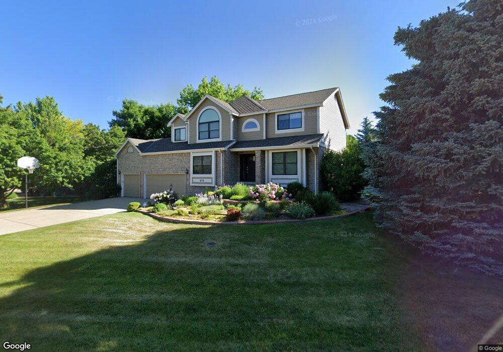
6133 Songbird Cir Boulder, CO 80303
Southeast Boulder NeighborhoodEstimated Value: $1,339,252 - $1,971,000
5
Beds
3
Baths
2,581
Sq Ft
$665/Sq Ft
Est. Value
About This Home
This home is located at 6133 Songbird Cir, Boulder, CO 80303 and is currently estimated at $1,715,313, approximately $664 per square foot. 6133 Songbird Cir is a home located in Boulder County with nearby schools including Douglass Elementary School, Nevin Platt Middle School, and Fairview High School.
Ownership History
Date
Name
Owned For
Owner Type
Purchase Details
Closed on
Feb 24, 1992
Bought by
Raymond Ellen G and Raymond Robert M
Current Estimated Value
Purchase Details
Closed on
Jan 6, 1987
Bought by
Raymond Ellen G and Raymond Robert M
Purchase Details
Closed on
Sep 26, 1986
Bought by
Raymond Ellen G and Raymond Robert M
Purchase Details
Closed on
Aug 10, 1984
Bought by
Raymond Ellen G and Raymond Robert M
Create a Home Valuation Report for This Property
The Home Valuation Report is an in-depth analysis detailing your home's value as well as a comparison with similar homes in the area
Home Values in the Area
Average Home Value in this Area
Purchase History
| Date | Buyer | Sale Price | Title Company |
|---|---|---|---|
| Raymond Ellen G | $280,500 | -- | |
| Raymond Ellen G | $233,300 | -- | |
| Raymond Ellen G | $275,200 | -- | |
| Raymond Ellen G | -- | -- |
Source: Public Records
Tax History Compared to Growth
Tax History
| Year | Tax Paid | Tax Assessment Tax Assessment Total Assessment is a certain percentage of the fair market value that is determined by local assessors to be the total taxable value of land and additions on the property. | Land | Improvement |
|---|---|---|---|---|
| 2025 | $9,170 | $99,294 | $31,050 | $68,244 |
| 2024 | $9,170 | $99,294 | $31,050 | $68,244 |
| 2023 | $9,029 | $105,485 | $26,371 | $82,799 |
| 2022 | $7,022 | $78,507 | $21,906 | $56,601 |
| 2021 | $6,699 | $80,767 | $22,537 | $58,230 |
| 2020 | $6,905 | $79,765 | $26,598 | $53,167 |
| 2019 | $6,796 | $79,765 | $26,598 | $53,167 |
| 2018 | $5,542 | $65,736 | $29,880 | $35,856 |
| 2017 | $6,042 | $72,675 | $33,034 | $39,641 |
| 2016 | $6,767 | $67,827 | $34,228 | $33,599 |
| 2015 | $6,097 | $56,500 | $25,552 | $30,948 |
| 2014 | $5,529 | $56,500 | $25,552 | $30,948 |
Source: Public Records
Map
Nearby Homes
- 1047 Cherryvale Rd
- 6137 Baseline Rd
- 819 Gapter Rd
- 853 Racquet Ln
- 6833 Fairview Dr
- 655 Cree Cir
- 695 Manhattan Dr Unit 109
- 695 Manhattan Dr Unit 219
- 645 Manhattan Place Unit 302
- 645 Manhattan Place Unit 304
- 500 Manhattan Dr Unit B1
- 625 Manhattan Place Unit 308
- 1209 Harrison Ct
- 4500 Baseline Rd Unit 3302
- 4500 Baseline Rd Unit 4104
- 4500 Baseline Rd Unit 2107
- 4630 Talbot Dr
- 500 Mohawk Dr Unit 510
- 4415 Laguna Place Unit 201
- 7035 S Boulder Rd
- 6121 Songbird Cir
- 6151 Songbird Cir
- 1287 S Teal Ct
- 6138 Songbird Cir
- 6117 Songbird Cir
- 6169 Songbird Cir
- 6154 Songbird Cir
- 6122 Songbird Cir
- 6094 Songbird Cir
- 1286 S Teal Ct
- 6174 Songbird Cir
- 6187 Songbird Cir
- 1228 Mallard Ct
- 1244 Mallard Ct
- 1298 S Teal Ct
- 6111 Reserve Dr
- 1266 Mallard Ct
- 1283 Blackbird Ct
- 6190 Songbird Cir
- 1325 N Teal Ct