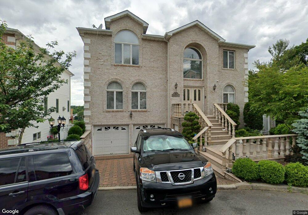
62 Michael Loop Staten Island, NY 10301
Emerson Hill NeighborhoodEstimated Value: $1,153,814 - $1,524,000
5
Beds
5
Baths
2,432
Sq Ft
$565/Sq Ft
Est. Value
About This Home
This home is located at 62 Michael Loop, Staten Island, NY 10301 and is currently estimated at $1,374,954, approximately $565 per square foot. 62 Michael Loop is a home located in Richmond County with nearby schools including P.S. 48 - William C. Wilcox, I.S. 49 Berta A Dreyfus, and New Dorp High School.
Ownership History
Date
Name
Owned For
Owner Type
Purchase Details
Closed on
May 15, 2009
Sold by
Hsu Raymond S and Lin Pi Erh
Bought by
Lin Celia Pi Erh and Hsu Daniel J
Current Estimated Value
Purchase Details
Closed on
Jan 28, 2000
Sold by
Tower Hill Development Corp
Bought by
Hsu Raymond S and Lin Celia Pi Erh
Home Financials for this Owner
Home Financials are based on the most recent Mortgage that was taken out on this home.
Original Mortgage
$436,000
Interest Rate
8.21%
Create a Home Valuation Report for This Property
The Home Valuation Report is an in-depth analysis detailing your home's value as well as a comparison with similar homes in the area
Home Values in the Area
Average Home Value in this Area
Purchase History
| Date | Buyer | Sale Price | Title Company |
|---|---|---|---|
| Lin Celia Pi Erh | -- | None Available | |
| Hsu Raymond S | $593,000 | Fidelity National Title Ins |
Source: Public Records
Mortgage History
| Date | Status | Borrower | Loan Amount |
|---|---|---|---|
| Previous Owner | Hsu Raymond S | $436,000 |
Source: Public Records
Tax History
| Year | Tax Paid | Tax Assessment Tax Assessment Total Assessment is a certain percentage of the fair market value that is determined by local assessors to be the total taxable value of land and additions on the property. | Land | Improvement |
|---|---|---|---|---|
| 2025 | $12,972 | $68,940 | $12,512 | $56,428 |
| 2024 | $12,972 | $73,620 | $11,054 | $62,566 |
| 2023 | $12,238 | $60,929 | $11,165 | $49,764 |
| 2022 | $11,475 | $57,480 | $12,600 | $44,880 |
| 2021 | $12,362 | $58,740 | $12,600 | $46,140 |
| 2020 | $16,103 | $61,200 | $12,600 | $48,600 |
| 2019 | $18,188 | $66,420 | $12,600 | $53,820 |
| 2018 | $11,253 | $55,200 | $12,600 | $42,600 |
| 2017 | $11,746 | $57,621 | $11,969 | $45,652 |
| 2016 | $10,867 | $54,360 | $12,183 | $42,177 |
| 2015 | $10,239 | $54,360 | $9,627 | $44,733 |
| 2014 | $10,239 | $53,352 | $9,448 | $43,904 |
Source: Public Records
Map
Nearby Homes
- 55 Nicole Loop
- 16 Diana Trail
- 260 Douglas Rd
- 35 Milden Ave
- 74 Longfellow Ave
- 201 Milford Ave
- 79 Endor Ave
- 47 Longfellow Ave
- 174 Douglas Rd
- 27 Witteman Place
- 755 Narrows Rd N Unit 602
- 755 Narrows Rd N Unit 513A
- 755 Narrows Rd N Unit 305
- 197 Seneca Ave
- 1 Douglas Ct
- 25 Beebe St
- 86 Tioga St
- 830 Howard Ave Unit 4H
- 830 Howard Ave Unit 3H
- 1430 Clove Rd
- 66 Michael Loop
- 58 Michael Loop
- 59 Nicole Loop
- 63 Nicole Loop
- 70 Michael Loop
- 54 Michael Loop
- 65 Michael Loop
- 67 Nicole Loop
- 69 Michael Loop
- 74 Michael Loop
- 50 Michael Loop
- 55 Michael Loop
- 51 Nicole Loop
- 71 Nicole Loop
- 73 Michael Loop
- 46 Michael Loop
- 46 Michael Loop Unit 2-A
- 46 Michael Loop Unit 2-B
- 37 Michael Loop
- 64 Nicole Loop
Your Personal Tour Guide
Ask me questions while you tour the home.