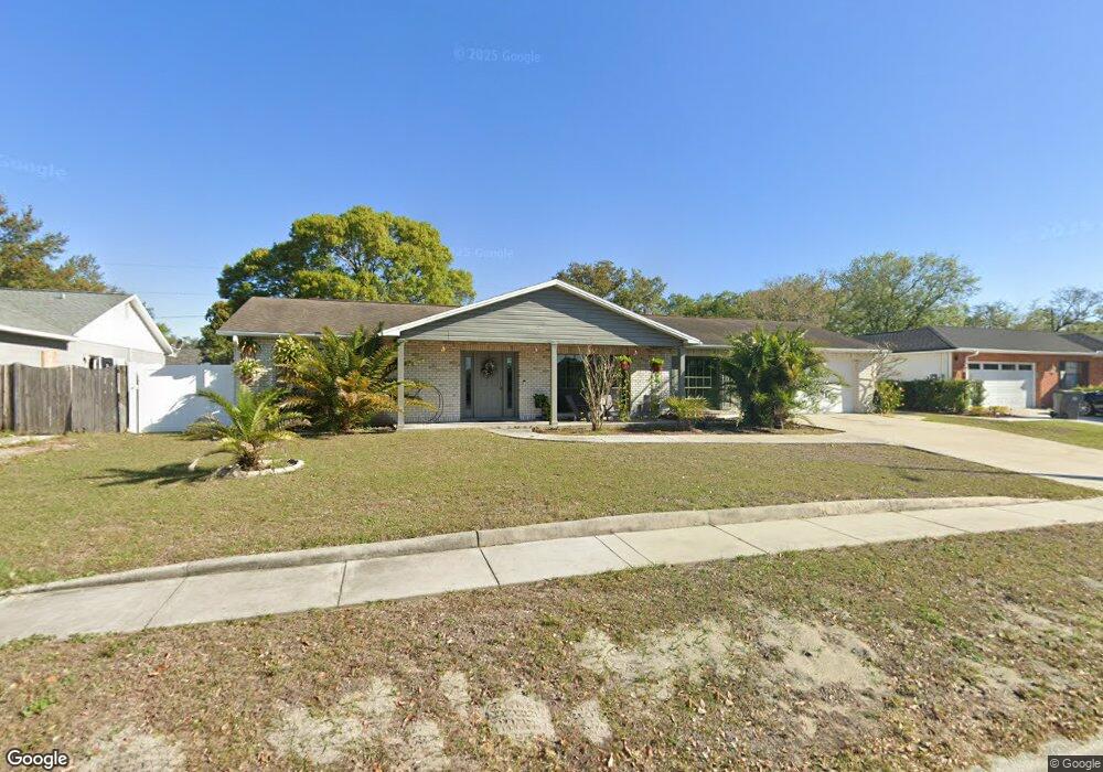
620 Rosemarie Ave Brandon, FL 33511
Estimated Value: $358,000 - $436,000
3
Beds
2
Baths
1,865
Sq Ft
$207/Sq Ft
Est. Value
About This Home
This home is located at 620 Rosemarie Ave, Brandon, FL 33511 and is currently estimated at $386,615, approximately $207 per square foot. 620 Rosemarie Ave is a home located in Hillsborough County with nearby schools including Kingswood Elementary School, Rodgers Middle School, and Brandon High School.
Ownership History
Date
Name
Owned For
Owner Type
Purchase Details
Closed on
Mar 10, 2010
Sold by
Eslick Rita
Bought by
Eslick Rita E
Current Estimated Value
Purchase Details
Closed on
Sep 14, 1995
Sold by
Fort Brooke Bk
Bought by
Eslick Rita
Home Financials for this Owner
Home Financials are based on the most recent Mortgage that was taken out on this home.
Original Mortgage
$75,150
Interest Rate
7.76%
Create a Home Valuation Report for This Property
The Home Valuation Report is an in-depth analysis detailing your home's value as well as a comparison with similar homes in the area
Home Values in the Area
Average Home Value in this Area
Purchase History
| Date | Buyer | Sale Price | Title Company |
|---|---|---|---|
| Eslick Rita E | -- | Attorney | |
| Eslick Rita | $83,800 | -- |
Source: Public Records
Mortgage History
| Date | Status | Borrower | Loan Amount |
|---|---|---|---|
| Closed | Eslick Rita | $75,150 |
Source: Public Records
Tax History Compared to Growth
Tax History
| Year | Tax Paid | Tax Assessment Tax Assessment Total Assessment is a certain percentage of the fair market value that is determined by local assessors to be the total taxable value of land and additions on the property. | Land | Improvement |
|---|---|---|---|---|
| 2024 | $5,317 | $283,700 | $100,505 | $183,195 |
| 2023 | $4,948 | $273,260 | $75,379 | $197,881 |
| 2022 | $4,837 | $312,591 | $75,379 | $237,212 |
| 2021 | $4,124 | $213,906 | $56,534 | $157,372 |
| 2020 | $3,780 | $198,368 | $50,252 | $148,116 |
| 2019 | $3,525 | $192,083 | $50,252 | $141,831 |
| 2018 | $3,285 | $179,648 | $0 | $0 |
| 2017 | $2,946 | $148,309 | $0 | $0 |
| 2016 | $2,736 | $122,586 | $0 | $0 |
| 2015 | $2,557 | $111,442 | $0 | $0 |
| 2014 | $2,275 | $101,311 | $0 | $0 |
| 2013 | -- | $95,504 | $0 | $0 |
Source: Public Records
Map
Nearby Homes
- 626 Marphil Loop
- 2617 Pegasus Ct
- 615 N Echo Dr
- 2209 Boxwood Way
- 611 Princeton St
- 2829 Bellwood Dr
- 2207 Princess Way
- 1009 Summer Breeze Dr
- 1006 Vista Cay Ct
- 1001 English Bluffs Ct
- 2733 Conch Hollow Dr
- 2819 Conch Hollow Dr
- 2712 Conch Hollow Dr
- 1641 Ledgestone Dr
- 2604 Knight Island Dr
- 2518 Knight Island Dr
- 2204 Krista Ln
- 401 Woodcrest Rd
- 1408 New Britain Dr
- 2910 Red Coat Cir
- 618 Rosemarie Ave
- 622 Rosemarie Ave
- 603 Marphil Loop
- 601 Marphil Loop
- 616 Rosemarie Ave
- 617 Rosemarie Ave
- 605 Marphil Loop
- 615 Rosemarie Ave
- 614 Rosemarie Ave
- 607 Marphil Loop
- 622 Sanfield St
- 624 Sanfield St
- 608 Marphil Loop
- 613 Rosemarie Ave
- 620 Sanfield St
- 626 Sanfield St
- 2607 S Kings Ave
- 618 Sanfield St
- 612 Rosemarie Ave
- 616 Sanfield St