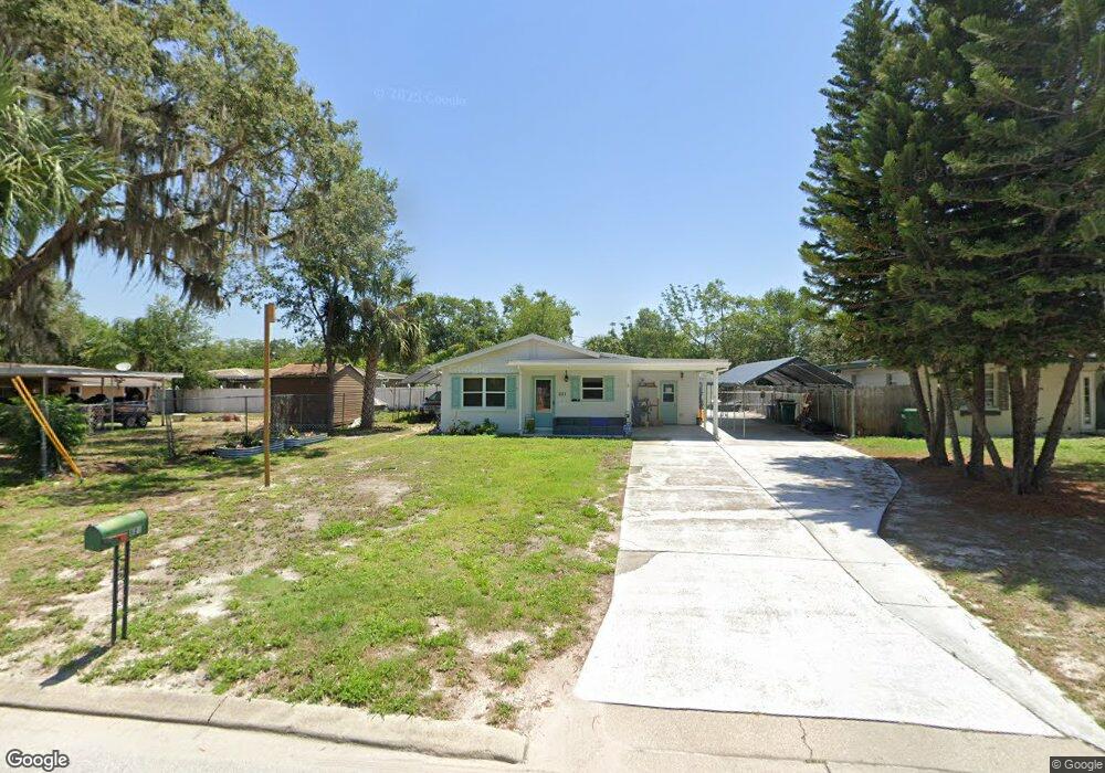
621 Starbird St Eustis, FL 32726
Estimated Value: $197,000 - $248,000
3
Beds
1
Bath
1,647
Sq Ft
$131/Sq Ft
Est. Value
About This Home
This home is located at 621 Starbird St, Eustis, FL 32726 and is currently estimated at $215,048, approximately $130 per square foot. 621 Starbird St is a home located in Lake County with nearby schools including Eustis Heights Elementary School, Eustis Middle School, and Eustis High School.
Ownership History
Date
Name
Owned For
Owner Type
Purchase Details
Closed on
Feb 13, 2024
Sold by
Green Jean B
Bought by
Green Jean B
Current Estimated Value
Purchase Details
Closed on
Jan 19, 2024
Sold by
Green Jean B
Bought by
Green Jean B and Potter Stacy
Purchase Details
Closed on
Sep 12, 2016
Sold by
Jones Michael F and Burgan Shannon
Bought by
Green Jean B
Home Financials for this Owner
Home Financials are based on the most recent Mortgage that was taken out on this home.
Original Mortgage
$95,978
Interest Rate
3.87%
Mortgage Type
FHA
Purchase Details
Closed on
Mar 11, 2014
Sold by
Jones Linda
Bought by
Jones Michael F
Purchase Details
Closed on
Nov 21, 2002
Sold by
Jones Doris A
Bought by
Jones Michael F and Jones Linda
Create a Home Valuation Report for This Property
The Home Valuation Report is an in-depth analysis detailing your home's value as well as a comparison with similar homes in the area
Home Values in the Area
Average Home Value in this Area
Purchase History
| Date | Buyer | Sale Price | Title Company |
|---|---|---|---|
| Green Jean B | $100 | None Listed On Document | |
| Green Jean B | $100 | None Listed On Document | |
| Green Jean B | $100 | None Listed On Document | |
| Green Jean B | $97,800 | Attorney | |
| Jones Michael F | -- | Attorney | |
| Jones Michael F | $47,000 | -- |
Source: Public Records
Mortgage History
| Date | Status | Borrower | Loan Amount |
|---|---|---|---|
| Previous Owner | Green Jean B | $95,978 |
Source: Public Records
Tax History
| Year | Tax Paid | Tax Assessment Tax Assessment Total Assessment is a certain percentage of the fair market value that is determined by local assessors to be the total taxable value of land and additions on the property. | Land | Improvement |
|---|---|---|---|---|
| 2026 | $572 | $64,580 | -- | -- |
| 2025 | $557 | $62,830 | -- | -- |
| 2024 | $557 | $62,830 | -- | -- |
| 2023 | $557 | $59,230 | $0 | $0 |
| 2022 | $558 | $57,510 | $0 | $0 |
| 2021 | $547 | $55,838 | $0 | $0 |
| 2020 | $568 | $55,068 | $0 | $0 |
| 2019 | $568 | $53,830 | $0 | $0 |
| 2018 | $552 | $52,827 | $0 | $0 |
| 2017 | $548 | $51,741 | $0 | $0 |
| 2016 | $545 | $51,783 | $0 | $0 |
| 2015 | $615 | $59,642 | $0 | $0 |
| 2014 | $615 | $59,169 | $0 | $0 |
Source: Public Records
Map
Nearby Homes
- 500 W Woodward Ave
- 834 Donnelly St
- 620 Titcomb St
- 34 Melody Cir
- 28 Melody Cir
- 27 Melody Cir
- 1021 Titcomb St
- 1111 South St
- 102 Sharps Cir
- 207 Sharps Cir
- 801 Lakeshore Dr
- 10 Sharps Cir
- 8a Sharps Cir
- 860 S Grove St
- 1215 Morin St
- 206 Osceola Ave
- 1033 S Grove St
- 312 Osceola Ave
- 1111 Lakeshore Dr Unit A3
- 1111 Lakeshore Dr Unit C4
- 633 Starbird St
- 504 W Woodward Ave
- 502 W Woodward Ave
- 602 Donnelly St
- 604 Donnelly St
- 600 W Woodward Ave
- 620 Starbird St
- 701 Starbird St
- 630 Starbird St
- 0 Donnelly
- 700 Donnelly St
- 640 Starbird St
- 610 W Woodward Ave
- 505 W Woodward Ave
- 706 Starbird St
- 503 W Woodward Ave
- 731 Starbird St
- 406 W Woodward Ave
- 603 Donnelly St
- 501 W Woodward Ave
Your Personal Tour Guide
Ask me questions while you tour the home.