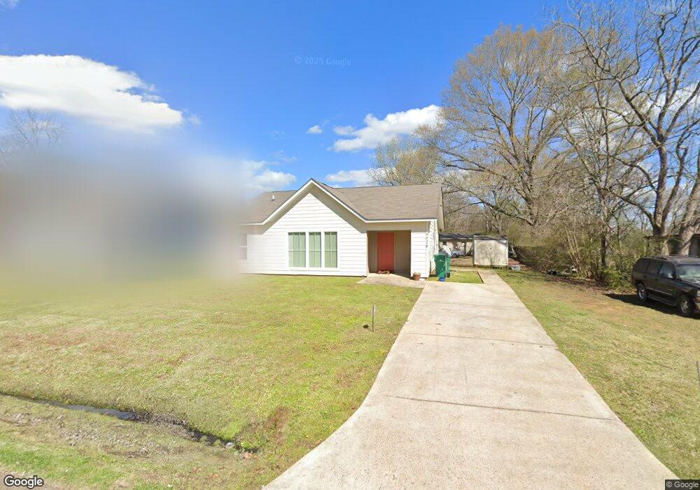
628 Coleman St Canton, MS 39046
Estimated Value: $106,696 - $211,000
Studio
--
Bath
1,319
Sq Ft
$112/Sq Ft
Est. Value
About This Home
This home is located at 628 Coleman St, Canton, MS 39046 and is currently estimated at $147,924, approximately $112 per square foot. 628 Coleman St is a home with nearby schools including Canton High School and Canton Academy.
Ownership History
Date
Name
Owned For
Owner Type
Purchase Details
Closed on
Dec 14, 2015
Sold by
Habitat For Humanity Mississippi Capital
Bought by
Phillips Mylinda J
Current Estimated Value
Home Financials for this Owner
Home Financials are based on the most recent Mortgage that was taken out on this home.
Original Mortgage
$72,588
Outstanding Balance
$51,895
Interest Rate
3.83%
Mortgage Type
Purchase Money Mortgage
Estimated Equity
$96,029
Purchase Details
Closed on
Mar 24, 2015
Sold by
The City Of Canton
Bought by
Habitat For Humanity
Purchase Details
Closed on
Jan 4, 2015
Sold by
Habitat For Humanity Mississippi Captial
Bought by
Phillips Mylinda J
Create a Home Valuation Report for This Property
The Home Valuation Report is an in-depth analysis detailing your home's value as well as a comparison with similar homes in the area
Home Values in the Area
Average Home Value in this Area
Purchase History
| Date | Buyer | Sale Price | Title Company |
|---|---|---|---|
| Phillips Mylinda J | -- | None Available | |
| Habitat For Humanity | -- | None Available | |
| Phillips Mylinda J | -- | None Available |
Source: Public Records
Mortgage History
| Date | Status | Borrower | Loan Amount |
|---|---|---|---|
| Open | Phillips Mylinda J | $72,588 |
Source: Public Records
Tax History
| Year | Tax Paid | Tax Assessment Tax Assessment Total Assessment is a certain percentage of the fair market value that is determined by local assessors to be the total taxable value of land and additions on the property. | Land | Improvement |
|---|---|---|---|---|
| 2025 | $770 | $6,697 | $0 | $0 |
| 2024 | $770 | $6,697 | $0 | $0 |
| 2023 | $847 | $6,697 | $0 | $0 |
| 2022 | $724 | $6,697 | $0 | $0 |
| 2021 | $638 | $6,402 | $0 | $0 |
| 2020 | $688 | $6,402 | $0 | $0 |
| 2019 | $688 | $6,402 | $0 | $0 |
| 2018 | $688 | $6,402 | $0 | $0 |
| 2017 | $676 | $6,283 | $0 | $0 |
| 2016 | $666 | $6,283 | $0 | $0 |
| 2015 | -- | $750 | $0 | $0 |
| 2014 | -- | $750 | $0 | $0 |
Source: Public Records
Map
Nearby Homes
- 125 Willow Way
- 383 Frost St
- 0 Finney Rd
- 3573 N Liberty St
- 108 E North St
- 700 Wayne Dr
- 114 Jody Dr
- 217 E Center St
- 594 Lincoln St
- 922 W Franklin St
- 0 Mississippi 16
- 221 E Center St
- 494 Washington St
- 138 E Fulton St
- 3668 N Liberty St
- 0 Jewell Williams Blvd
- 365 Walnut St
- 3267 S Liberty St
- 140 E Semmes St
- 398 Green Acres Dr
- 630 Coleman St
- 465 Cherry St
- 461 Cherry St
- 472 Cherry St
- 468 Cherry St
- 457 Cherry St
- 460 Cherry St
- 460 Cherry St
- 617 Coleman St
- 453 Cherry St
- 610 Coleman St
- 452 Cherry St
- 448 Cherry St
- 447 Cherry St
- 715 Coleman St
- 737 Martin Luther King Dr
- 747 Martin Luther King Dr
- 747 Martin Luther King Dr
- 718 Coleman St
- 719 Coleman St