
Seller's Agent in 2025
Derek Clapp
The Agency - Boulder
(303) 817-6670
10 in this area
31 Total Sales
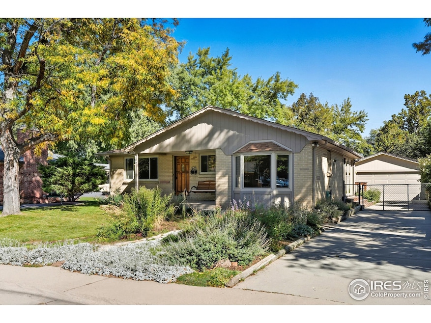


Welcome to this beautifully maintained and expanded South Boulder home boasting 2,632-square feet, 5 bedrooms, 3 bathrooms, and a rare oversized 2 car detached garage, all situated on an oversized and manicured lot. All of this set on a quiet street in one of Boulder's most desirable neighborhoods, enjoy convenient access to top-rated schools, multiple trails and parks, University of Colorado, and Table Mesa shopping center. The inviting front entrance leads into an expansive eat-in kitchen with newer stainless steel appliances, two sinks, bay window and large built-in pantry. The kitchen flows seamlessly into the sunroom and out onto a spacious back deck, all overlooking a fully fenced yard with lush landscaping and a privacy fence, perfect for entertaining or BBQs. Original hardwood floors on the main level extend throughout the living room, dining area, and bedrooms. Ideal layout with main level offering oversized living room, 3 bedrooms and 2 baths, with primary bedroom featuring it's own half bath. Two additional non-conforming bedrooms, 1 bath, large family room and laundry in basement. Many big ticket items have been replaced, such as new sewer line and water line in 2022, roof was replaced in 2014 with class 4 shingles, new furnace in 2014, new water heater in 2024 and updated windows on main level.
Last Agent to Sell the Property
The Agency - Boulder License #100036085 Listed on: 10/09/2025
| Date | Type | Sale Price | Title Company |
|---|---|---|---|
| Warranty Deed | $995,000 | Land Title | |
| Special Warranty Deed | -- | -- | |
| Warranty Deed | -- | -- | |
| Warranty Deed | $175,000 | -- | |
| Deed | -- | -- | |
| Deed | $64,500 | -- |
| Date | Status | Loan Amount | Loan Type |
|---|---|---|---|
| Open | $890,525 | New Conventional | |
| Previous Owner | $161,500 | No Value Available |
| Date | Event | Price | List to Sale | Price per Sq Ft |
|---|---|---|---|---|
| 11/06/2025 11/06/25 | Sold | $995,000 | 0.0% | $378 / Sq Ft |
| 10/10/2025 10/10/25 | For Sale | $995,000 | -- | $378 / Sq Ft |
| Year | Tax Paid | Tax Assessment Tax Assessment Total Assessment is a certain percentage of the fair market value that is determined by local assessors to be the total taxable value of land and additions on the property. | Land | Improvement |
|---|---|---|---|---|
| 2025 | $5,456 | $55,881 | $30,400 | $25,481 |
| 2024 | $5,456 | $55,881 | $30,400 | $25,481 |
| 2023 | $5,359 | $61,184 | $35,919 | $28,951 |
| 2022 | $4,708 | $49,888 | $26,744 | $23,144 |
| 2021 | $4,493 | $51,323 | $27,513 | $23,810 |
| 2020 | $4,322 | $49,657 | $26,026 | $23,631 |
| 2019 | $4,256 | $49,657 | $26,026 | $23,631 |
| 2018 | $3,964 | $45,720 | $23,976 | $21,744 |
| 2017 | $3,840 | $50,546 | $26,507 | $24,039 |
| 2016 | $3,390 | $39,163 | $23,243 | $15,920 |
| 2015 | $3,210 | $34,061 | $13,612 | $20,449 |
| 2014 | $2,864 | $34,061 | $13,612 | $20,449 |
Seller's Agent in 2025
Derek Clapp
The Agency - Boulder
(303) 817-6670
10 in this area
31 Total Sales
Buyer's Agent in 2025
Lauren Daniels
milehimodern - Boulder
(815) 236-8005
4 in this area
83 Total Sales
Source: IRES MLS
MLS Number: IRE1045384
APN: 1577081-02-011
Disclaimer: Certain information contained herein is derived from information provided by parties other than Homes.com. All information provided is deemed reliable, but is not guaranteed to be accurate and should be independently verified.
![]() Information source: Information and Real Estate Services, LLC. Provided for limited non-commercial use only under IRES Rules © Copyright IRES.
Information source: Information and Real Estate Services, LLC. Provided for limited non-commercial use only under IRES Rules © Copyright IRES.
Based on information submitted to the MLS GRID. All data is obtained from various sources and may not have been verified by broker or MLS GRID. Supplied Open House Information is subject to change without notice. All information should be independently reviewed and verified for accuracy. Properties may or may not be listed by the office/agent presenting the information. Some IDX listings have been excluded from this website. Listing information is provided exclusively for consumers' personal, non-commercial use and may not be used for any purpose other than to identify prospective properties consumers may be interested in purchasing.
Information deemed reliable but not guaranteed by the MLS.
Based on information submitted to the MLS GRID
Ask me questions while you tour the home.