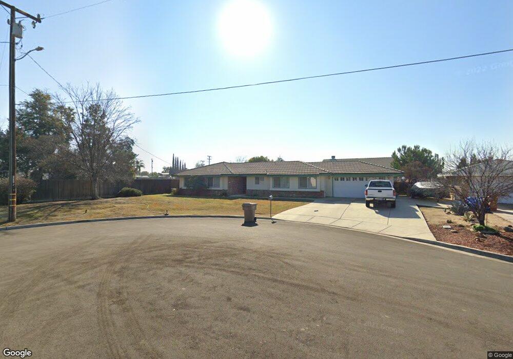
6501 Desmond Ct Bakersfield, CA 93308
Olive Drive Area NeighborhoodEstimated Value: $437,000 - $453,743
3
Beds
2
Baths
1,512
Sq Ft
$295/Sq Ft
Est. Value
About This Home
This home is located at 6501 Desmond Ct, Bakersfield, CA 93308 and is currently estimated at $445,686, approximately $294 per square foot. 6501 Desmond Ct is a home located in Kern County with nearby schools including Olive Drive Elementary School, Norris Middle School, and Centennial High School.
Ownership History
Date
Name
Owned For
Owner Type
Purchase Details
Closed on
Jun 5, 2023
Sold by
Register Jere D
Bought by
Register Mitchell and Register Stephanie
Current Estimated Value
Home Financials for this Owner
Home Financials are based on the most recent Mortgage that was taken out on this home.
Original Mortgage
$350,000
Outstanding Balance
$340,945
Interest Rate
6.57%
Mortgage Type
New Conventional
Estimated Equity
$104,741
Create a Home Valuation Report for This Property
The Home Valuation Report is an in-depth analysis detailing your home's value as well as a comparison with similar homes in the area
Home Values in the Area
Average Home Value in this Area
Purchase History
| Date | Buyer | Sale Price | Title Company |
|---|---|---|---|
| Register Mitchell | $375,000 | Placer Title |
Source: Public Records
Mortgage History
| Date | Status | Borrower | Loan Amount |
|---|---|---|---|
| Open | Register Mitchell | $350,000 |
Source: Public Records
Tax History Compared to Growth
Tax History
| Year | Tax Paid | Tax Assessment Tax Assessment Total Assessment is a certain percentage of the fair market value that is determined by local assessors to be the total taxable value of land and additions on the property. | Land | Improvement |
|---|---|---|---|---|
| 2025 | $4,913 | $382,500 | $76,500 | $306,000 |
| 2024 | $2,359 | $375,000 | $75,000 | $300,000 |
| 2023 | $2,359 | $157,625 | $14,933 | $142,692 |
| 2022 | $2,293 | $154,536 | $14,641 | $139,895 |
| 2021 | $2,211 | $151,507 | $14,354 | $137,153 |
| 2020 | $2,134 | $149,955 | $14,207 | $135,748 |
| 2019 | $2,102 | $149,955 | $14,207 | $135,748 |
| 2018 | $2,030 | $144,135 | $13,656 | $130,479 |
| 2017 | $2,030 | $141,311 | $13,389 | $127,922 |
| 2016 | $1,902 | $138,542 | $13,127 | $125,415 |
| 2015 | $1,856 | $136,463 | $12,930 | $123,533 |
| 2014 | $1,810 | $133,791 | $12,677 | $121,114 |
Source: Public Records
Map
Nearby Homes
- 6619 Desmond Ct
- 6007 Pembroke Ave
- 6000 Eugene Place
- 6100 Carter Ave
- 6701 Hooper Ave
- 6008 Carter Ave
- 6300 Mignonette St
- 5306 Deville Ct
- 5900 Carter Ave
- 6301 Spring Valley Dr
- 6304 Stanley St
- 7001 Eloy Ave
- 6338 Bama Rose Ct
- 6107 Mohawk St
- 6317 Tallman Ave
- 6709 Cedarcrest Ave
- 7112 Brookshire Ave
- 7309 Angela Ave
- 6600 Cedarcrest Ave
- 6418 Abby Rose Ave