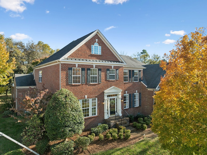
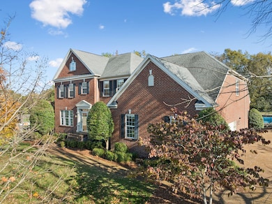
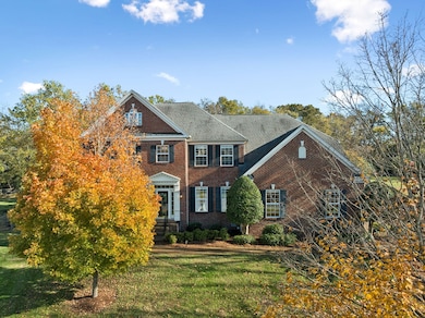

652 Aylesford Ln Franklin, TN 37069
Estimated payment $8,252/month
Highlights
- In Ground Pool
- Wood Flooring
- Great Room
- Walnut Grove Elementary School Rated A
- Sun or Florida Room
- Double Oven
About This Home
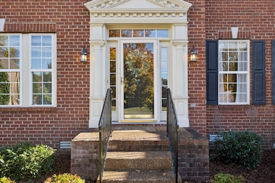
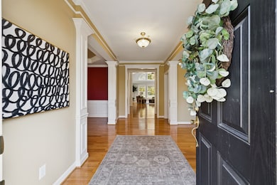
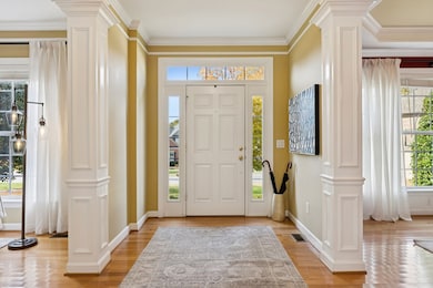
Welcome to 652 Aylesford Lane — a stunning luxury residence offering an exceptional blend of elegance, comfort, and functionality. This 3-bed, 3.5-bath home boasts soaring ceilings and an abundance of natural light, creating an open and inviting atmosphere throughout. The spacious floor plan features an eat-in kitchen, formal dining room, and dedicated office/study, providing flexible spaces ideal for both everyday living and working from home. Enjoy year-round relaxation in the bright sunroom overlooking the backyard oasis. Upstairs, you’ll find a generous bonus room and a versatile loft area that can easily be converted into a 4th bedroom — a feature successfully incorporated in similar floor plans throughout the neighborhood. Retreat to the luxurious primary suite on the main level, complete with two walk-in closets and private access to the in-ground swimming pool through the serene spa-like bath. The outdoor space is perfect for entertaining or unwinding, offering a resort-style escape right at home. Situated on a cul-de-sac, with thoughtful design and premium finishes throughout, this home is the perfect blend of sophistication and livability. Schedule your private tour today and experience the lifestyle that awaits at 652 Aylesford Lane.
Listing Agent
Keller Williams Realty Brokerage Phone: 7275126157 License #352587 Listed on: 11/05/2025

Home Details
Home Type
- Single Family
Est. Annual Taxes
- $3,177
Year Built
- Built in 2003
Lot Details
- 0.61 Acre Lot
- Lot Dimensions are 98 x 212
- Cul-De-Sac
HOA Fees
- $66 Monthly HOA Fees
Parking
- 3 Car Garage
- Side Facing Garage
Home Design
- Brick Exterior Construction
Interior Spaces
- 4,600 Sq Ft Home
- Property has 1 Level
- Gas Fireplace
- Great Room
- Living Room with Fireplace
- Sun or Florida Room
Kitchen
- Eat-In Kitchen
- Double Oven
- Built-In Electric Range
- Microwave
- Dishwasher
- Disposal
Flooring
- Wood
- Carpet
- Tile
Bedrooms and Bathrooms
- 3 Bedrooms | 1 Main Level Bedroom
- Double Vanity
Schools
- Walnut Grove Elementary School
- Grassland Middle School
- Franklin High School
Additional Features
- In Ground Pool
- Central Heating and Cooling System
Community Details
- River Landing Sec 9 Subdivision
Listing and Financial Details
- Assessor Parcel Number 094038L F 01200 00006038L
Map
Home Values in the Area
Average Home Value in this Area
Tax History
| Year | Tax Paid | Tax Assessment Tax Assessment Total Assessment is a certain percentage of the fair market value that is determined by local assessors to be the total taxable value of land and additions on the property. | Land | Improvement |
|---|---|---|---|---|
| 2025 | $3,177 | $350,400 | $100,000 | $250,400 |
| 2024 | $3,177 | $169,000 | $47,500 | $121,500 |
| 2023 | $3,177 | $169,000 | $47,500 | $121,500 |
| 2022 | $3,177 | $169,000 | $47,500 | $121,500 |
| 2021 | $3,177 | $169,000 | $47,500 | $121,500 |
| 2020 | $3,016 | $135,850 | $32,500 | $103,350 |
| 2019 | $3,016 | $135,850 | $32,500 | $103,350 |
| 2018 | $2,921 | $135,850 | $32,500 | $103,350 |
| 2017 | $2,921 | $135,850 | $32,500 | $103,350 |
| 2016 | $0 | $135,850 | $32,500 | $103,350 |
| 2015 | -- | $115,000 | $27,325 | $87,675 |
| 2014 | -- | $115,000 | $27,325 | $87,675 |
Property History
| Date | Event | Price | List to Sale | Price per Sq Ft |
|---|---|---|---|---|
| 11/07/2025 11/07/25 | For Sale | $1,500,000 | -- | $326 / Sq Ft |
Purchase History
| Date | Type | Sale Price | Title Company |
|---|---|---|---|
| Warranty Deed | $423,295 | -- | |
| Special Warranty Deed | $1,045,000 | -- |
Mortgage History
| Date | Status | Loan Amount | Loan Type |
|---|---|---|---|
| Open | $312,000 | Purchase Money Mortgage | |
| Closed | $90,095 | No Value Available |
Source: Realtracs
MLS Number: 3040028
APN: 038L-F-012.00
Disclaimer: Certain information contained herein is derived from information provided by parties other than Homes.com. All information provided is deemed reliable, but is not guaranteed to be accurate and should be independently verified.
![]() Based on information submitted to the MLS GRID. All data is obtained from various sources and may not have been verified by broker or MLS GRID. Supplied Open House Information is subject to change without notice. All information should be independently reviewed and verified for accuracy. Properties may or may not be listed by the office/agent presenting the information. Some IDX listings have been excluded from this website.
Based on information submitted to the MLS GRID. All data is obtained from various sources and may not have been verified by broker or MLS GRID. Supplied Open House Information is subject to change without notice. All information should be independently reviewed and verified for accuracy. Properties may or may not be listed by the office/agent presenting the information. Some IDX listings have been excluded from this website.
The Digital Millennium Copyright Act of 1998, 17 U.S.C. § 512 (the “DMCA”) provides recourse for copyright owners who believe that material appearing on the Internet infringes their rights under U.S. copyright law. If you believe in good faith that any content or material made available in connection with our website or services infringes your copyright, you (or your agent) may send us a notice requesting that the content or material be removed, or access to it blocked.
Notices must be sent in writing by email to DMCAnotice@MLSGrid.com.
The DMCA requires that your notice of alleged copyright infringement include the following information:
(1) description of the copyrighted work that is the subject of claimed infringement;
(2) description of the alleged infringing content and information sufficient to permit us to locate the content;
(3) contact information for you, including your address, telephone number and email address;
(4) a statement by you that you have a good faith belief that the content in the manner complained of is not authorized by the copyright owner, or its agent, or by the operation of any law;
(5) a statement by you, signed under penalty of perjury, that the information in the notification is accurate and that you have the authority to enforce the copyrights that are claimed to be infringed; and
(6) a physical or electronic signature of the copyright owner or a person authorized to act on the copyright owner’s behalf. Failure to include all of the above information may result in the delay of the processing of your complaint.
- 1203 Gillette Ct
- 320 Cotton Ln
- 0 Hillsboro Rd Unit 22948325
- 0 Hillsboro Rd Unit RTC2806259
- 284 Gillette Dr
- 405 Meadowgreen Dr
- 604 Meadowgreen Dr
- 298 Gillette Dr
- 113 Pine Circle Dr
- 1013 Buena Vista Dr
- 1576 Old Hillsboro Rd
- 426 Essex Park Cir
- 826 Brandyleigh Ct
- 2064 Hillsboro Rd
- 913 Idlewild Ct
- 810 Brandyleigh Ct
- 2954 Del Rio Pike
- 2090 Hamilton Way
- 2958 Del Rio Pike
- 1860 Old Natchez Trace
- 1576 Old Hillsboro Rd
- 256 Ben Brush Cir
- 508 Caselton Ct
- 230 Boxwood Dr
- 2513 Hillsboro Rd
- 2004 Granville Rd
- 804 Ronald Dr
- 350 Astor Way
- 404 Granville Rd Unit 404
- 202 Harris Ct
- 1208 Granville Rd Unit 1208
- 6398 Temple Rd
- 613 Hillsboro Rd Unit A-11
- 813 Del Rio Pike
- 1972 Sunny Side Dr
- 801 Del Rio Pike
- 430 Wiregrass Ln
- 746 Harrow Ln
- 911 Jewell Ave
- 1125 Magnolia Dr