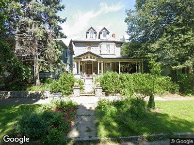
661 661 Laurel Ave St. Paul, MN 55104
Summit-University NeighborhoodEstimated Value: $687,000 - $754,000
6
Beds
5
Baths
3,494
Sq Ft
$204/Sq Ft
Est. Value
About This Home
This home is located at 661 661 Laurel Ave, St. Paul, MN 55104 and is currently estimated at $711,029, approximately $203 per square foot. 661 661 Laurel Ave is a home located in Ramsey County with nearby schools including Maxfield Magnet Elementary School, Hidden River Middle School, and Central Senior High School.
Ownership History
Date
Name
Owned For
Owner Type
Purchase Details
Closed on
Aug 20, 2010
Sold by
Johnson Richard W and Johnson Debra K
Bought by
Murphy Mark A and Tucker Pamela P
Current Estimated Value
Home Financials for this Owner
Home Financials are based on the most recent Mortgage that was taken out on this home.
Original Mortgage
$250,000
Interest Rate
4.6%
Mortgage Type
Credit Line Revolving
Purchase Details
Closed on
Jul 29, 1996
Sold by
Badar Timothy G and Badar Lauri J
Bought by
Johnson Richard W and Johnson Debra Kay
Create a Home Valuation Report for This Property
The Home Valuation Report is an in-depth analysis detailing your home's value as well as a comparison with similar homes in the area
Home Values in the Area
Average Home Value in this Area
Purchase History
| Date | Buyer | Sale Price | Title Company |
|---|---|---|---|
| Johnson Richard W | $140,000 | -- |
Source: Public Records
Mortgage History
| Date | Status | Borrower | Loan Amount |
|---|---|---|---|
| Closed | Murphy Mark A | $170,000 | |
| Closed | Murphy Mark A | $288,000 | |
| Closed | Murphy Mark A | $250,000 |
Source: Public Records
Tax History Compared to Growth
Tax History
| Year | Tax Paid | Tax Assessment Tax Assessment Total Assessment is a certain percentage of the fair market value that is determined by local assessors to be the total taxable value of land and additions on the property. | Land | Improvement |
|---|---|---|---|---|
| 2023 | $10,136 | $626,300 | $139,800 | $486,500 |
| 2022 | $9,140 | $559,200 | $139,800 | $419,400 |
| 2021 | $8,822 | $542,000 | $139,800 | $402,200 |
| 2020 | $9,530 | $546,800 | $139,800 | $407,000 |
| 2019 | $8,770 | $548,700 | $139,800 | $408,900 |
| 2018 | $7,100 | $506,400 | $139,800 | $366,600 |
| 2017 | $7,446 | $422,000 | $139,800 | $282,200 |
| 2016 | $7,430 | $0 | $0 | $0 |
| 2015 | $7,850 | $429,500 | $129,000 | $300,500 |
| 2014 | $6,754 | $0 | $0 | $0 |
Source: Public Records
Map
Nearby Homes
- 666 Ashland Ave Unit 1
- 650 Holly Ave
- 633 Dayton Ave Unit 4
- 757 Laurel Ave
- 709 Portland Ave Unit 6
- 161 Kent St
- 28 Saint Albans St N Unit 4N
- 553 Ashland Ave Unit 553
- 545 Ashland Ave Unit 4
- 545 Holly Ave
- 794 Laurel Ave
- 518 Laurel Ave
- 710 Summit Ave Unit 4
- 117 MacKubin St Unit 2
- 604 Summit Ave Unit 6041
- 598 Summit Ave Unit 1
- 30 Saint Albans St S Unit 6A
- 760 Iglehart Ave
- 71 MacKubin St
- 627 Grand Ave Unit 1
- 661 661 Laurel Ave
- 661 Laurel Ave
- 667 Laurel Ave
- 657 Laurel Ave
- 669 Laurel Ave
- 645 Laurel Ave
- 666 Hague Ave
- 654 Hague Ave
- 128 Saint Albans St N
- 668 Hague Ave
- 668 Laurel Ave
- 646 Hague Ave
- 658 Laurel Ave
- 658 658 Laurel Ave
- 643 Laurel Ave
- 643 Laurel Ave Unit Lower
- 654 Laurel Ave
- 648 Laurel Ave
- 670 Laurel Ave
- 637 Laurel Ave