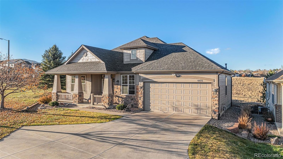

6615 S Robb Ln Littleton, CO 80127
Powderhorn NeighborhoodEstimated payment $5,025/month
Highlights
- Primary Bedroom Suite
- Open Floorplan
- Vaulted Ceiling
- Park Western Place Elementary School Rated 10
- Deck
- Wood Flooring
About This Home
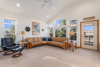
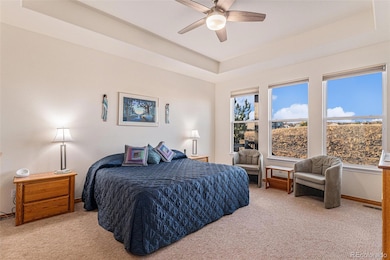
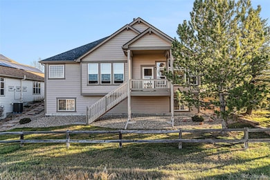
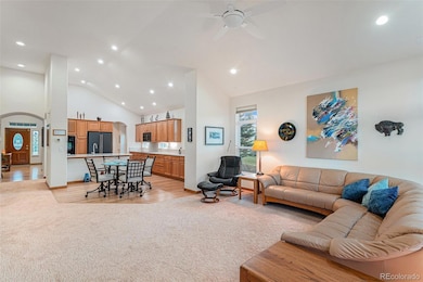
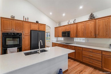
THIS IS A MUST SEE! ASAP! This impeccable home is located in the highly coveted Eagle View Patio Homes community of Littleton. Nestled in a serene enclave of just 64 homes, this sought-after neighborhood offers a rare blend of privacy, natural beauty, and low-maintenance living. Residents enjoy peaceful streets, well-manicured surroundings, and a warm sense of community—all framed by the stunning foothill views that make this area so desirable. This beautifully maintained home is immaculate from the moment you step inside. Thoughtfully updated with modern appliances, pristine, like-new carpeting and refinished hardwood floors, the interior feels fresh, bright, and completely move-in ready. High ceilings and large windows amplify the natural light and create a spacious, airy atmosphere throughout. The home features two private bedroom suites, ideal for hosting guests or enjoying personal retreat spaces, as well as a generously sized den perfect for a home office, library, or media room. The unfinished garden-level basement is a rare find—light-filled and easily tailored to your own vision, whether you dream of a recreation room, gym, guest suite, or hobby space. Outside, the property truly shines. Situated at the end of a quiet street this home offers exceptional privacy and one of the largest lots in the community. It backs to a lush greenbelt and walking path, providing peaceful views from an elevated deck. An oversized heated garage adds comfort and convenience year-round, offering extra storage or workspace. Living here means tranquility without isolation. Residents appreciate the low-maintenance lifestyle, friendly neighbors, and immediate access to walking paths, parks, and nearby conveniences. It’s a place where mornings begin with peaceful strolls through the greenbelt and evenings end with quiet sunsets over the foothills. 6615 S Robb Lane is more than a home—it’s a rare opportunity in one of Littleton’s most desirable patio-home communities.
Listing Agent
Keller Williams Advantage Realty LLC Brokerage Email: sophia@pureenergyhometeam.com,303-995-2042 License #100097472 Listed on: 11/21/2025

Home Details
Home Type
- Single Family
Est. Annual Taxes
- $4,917
Year Built
- Built in 2006 | Remodeled
Lot Details
- 9,909 Sq Ft Lot
- Cul-De-Sac
- South Facing Home
- Landscaped
- Corner Lot
- Many Trees
- Property is zoned P-D
HOA Fees
- $258 Monthly HOA Fees
Parking
- 3 Car Attached Garage
- Parking Storage or Cabinetry
- Heated Garage
- Dry Walled Garage
- Epoxy
Home Design
- Frame Construction
- Composition Roof
- Wood Siding
- Stone Siding
- Concrete Block And Stucco Construction
Interior Spaces
- 1-Story Property
- Open Floorplan
- Built-In Features
- Vaulted Ceiling
- Ceiling Fan
- Gas Log Fireplace
- Double Pane Windows
- Window Treatments
- Entrance Foyer
- Living Room with Fireplace
- Dining Room
- Home Office
- Laundry Room
Kitchen
- Eat-In Kitchen
- Double Oven
- Cooktop
- Microwave
- Freezer
- Dishwasher
- Kitchen Island
- Quartz Countertops
- Laminate Countertops
Flooring
- Wood
- Carpet
- Tile
Bedrooms and Bathrooms
- 2 Main Level Bedrooms
- Primary Bedroom Suite
- En-Suite Bathroom
- Walk-In Closet
Unfinished Basement
- Partial Basement
- Basement Window Egress
Home Security
- Smart Thermostat
- Carbon Monoxide Detectors
Outdoor Features
- Deck
- Covered Patio or Porch
- Rain Gutters
Schools
- Powderhorn Elementary School
- Summit Ridge Middle School
- Dakota Ridge High School
Utilities
- Forced Air Heating and Cooling System
- Heating System Uses Natural Gas
- 110 Volts
- Natural Gas Connected
- Gas Water Heater
- High Speed Internet
- Cable TV Available
Community Details
- Association fees include ground maintenance, recycling, snow removal, trash
- Kc And Associates Association, Phone Number (303) 933-6279
- Eagle View Subdivision
- Greenbelt
Listing and Financial Details
- Exclusions: Washer and Dryer
- Property held in a trust
- Assessor Parcel Number 436301
Map
Home Values in the Area
Average Home Value in this Area
Tax History
| Year | Tax Paid | Tax Assessment Tax Assessment Total Assessment is a certain percentage of the fair market value that is determined by local assessors to be the total taxable value of land and additions on the property. | Land | Improvement |
|---|---|---|---|---|
| 2024 | $4,915 | $50,184 | $18,226 | $31,958 |
| 2023 | $4,915 | $50,184 | $18,226 | $31,958 |
| 2022 | $4,454 | $44,647 | $19,311 | $25,336 |
| 2021 | $4,511 | $45,932 | $19,867 | $26,065 |
| 2020 | $3,985 | $40,673 | $17,143 | $23,530 |
| 2019 | $3,936 | $40,673 | $17,143 | $23,530 |
| 2018 | $3,332 | $40,452 | $13,052 | $27,400 |
| 2017 | $3,041 | $40,452 | $13,052 | $27,400 |
| 2016 | $3,601 | $37,996 | $9,834 | $28,162 |
| 2015 | $3,580 | $37,996 | $9,834 | $28,162 |
| 2014 | $3,580 | $35,422 | $10,179 | $25,243 |
Property History
| Date | Event | Price | List to Sale | Price per Sq Ft |
|---|---|---|---|---|
| 11/21/2025 11/21/25 | For Sale | $825,000 | -- | $376 / Sq Ft |
Purchase History
| Date | Type | Sale Price | Title Company |
|---|---|---|---|
| Interfamily Deed Transfer | -- | None Available | |
| Warranty Deed | $565,000 | Equity Title Of Colorado | |
| Interfamily Deed Transfer | -- | None Available | |
| Warranty Deed | $494,161 | Security Title |
Mortgage History
| Date | Status | Loan Amount | Loan Type |
|---|---|---|---|
| Open | $390,000 | New Conventional | |
| Previous Owner | $225,000 | Unknown |
Source: REcolorado®
MLS Number: 3972722
APN: 59-213-16-003
Disclaimer: Certain information contained herein is derived from information provided by parties other than Homes.com. All information provided is deemed reliable, but is not guaranteed to be accurate and should be independently verified.
![]() The content relating to real estate for sale in this Web site comes in part from the Internet Data eXchange (“IDX”) program of METROLIST, INC., DBA RECOLORADO®. Real estate listings held by brokers other than Ten-X are marked with the IDX Logo. This information is being provided for the consumers’ personal, non-commercial use and may not be used for any other purpose. All information subject to change and should be independently verified.
The content relating to real estate for sale in this Web site comes in part from the Internet Data eXchange (“IDX”) program of METROLIST, INC., DBA RECOLORADO®. Real estate listings held by brokers other than Ten-X are marked with the IDX Logo. This information is being provided for the consumers’ personal, non-commercial use and may not be used for any other purpose. All information subject to change and should be independently verified.
This publication is designed to provide information with regard to the subject matter covered. It is displayed with the understanding that the publisher and authors are not engaged in rendering real estate, legal, accounting, tax, or other professional services and that the publisher and authors are not offering such advice in this publication. If real estate, legal, or other expert assistance is required, the services of a competent, professional person should be sought.
The information contained in this publication is subject to change without notice. METROLIST, INC., DBA RECOLORADO MAKES NO WARRANTY OF ANY KIND WITH REGARD TO THIS MATERIAL, INCLUDING, BUT NOT LIMITED TO, THE IMPLIED WARRANTIES OF MERCHANTABILITY AND FITNESS FOR A PARTICULAR PURPOSE. METROLIST, INC., DBA RECOLORADO SHALL NOT BE LIABLE FOR ERRORS CONTAINED HEREIN OR FOR ANY DAMAGES IN CONNECTION WITH THE FURNISHING, PERFORMANCE, OR USE OF THIS MATERIAL.
PUBLISHER’S NOTICE: All real estate advertised herein is subject to the Federal Fair Housing Act and the Colorado Fair Housing Act, which Acts make it illegal to make or publish any advertisement that indicates any preference, limitation, or discrimination based on race, color, religion, sex, handicap, familial status, or national origin.
METROLIST, INC., DBA RECOLORADO will not knowingly accept any advertising for real estate that is in violation of the law. All persons are hereby informed that all dwellings advertised are available on an equal opportunity basis.
© 2025 METROLIST, INC., DBA RECOLORADO® – All Rights Reserved. 6455 S. Yosemite St., Suite 500 Greenwood Village, CO 80111 USA
ALL RIGHTS RESERVED WORLDWIDE. No part of this publication may be reproduced, adapted, translated, stored in a retrieval system or transmitted in any form or by any means, electronic, mechanical, photocopying, recording, or otherwise, without the prior written permission of the publisher. The information contained herein including but not limited to all text, photographs, digital images, virtual tours, may be seeded and monitored for protection and tracking.
- 11632 W Quarles Ave
- 11411 W Cooper Dr
- 6763 S Robb Ct
- 6424 S Routt St
- 6542 S Pierson Ct
- 8278 S Quail St
- 6616 S Oak Cir
- 12118 W Cooper Dr
- 6588 S Oak Cir
- 10678 W Peakview Dr
- 6325 S Oak Way
- 10636 W Walker Place
- 11816 W Maplewood Ave
- 7073 S Robb St
- 6232 S Owens Ct
- 6154 S Parfet St
- 11445 W Maplewood Ave
- 7060 S Oak Ct
- 6306 S Miller Ct
- 5995 S Taft Way
- 11453 W Burgundy Ave
- 10587 W Maplewood Dr Unit C
- 10229 W Fair Ave Unit B
- 7423 S Quail Cir Unit 1516
- 7423 S Quail Cir Unit 1526
- 12718 W Burgundy Place
- 7442 S Quail Cir Unit 2124
- 13310 W Coal Mine Dr
- 12024 W Cross Dr Unit 206
- 12208 W Dorado Place Unit 207
- 12317 W Gould Ave
- 12338 W Dorado Place Unit 104
- 12183 W Cross Dr Unit 101
- 12093 W Cross Dr Unit 301
- 6708 S Holland Way
- 5815 S Zang St
- 5906 S Jellison St
- 11847 W Berry Ave
- 5543 S Moore St
- 12044 W Ken Caryl Cir