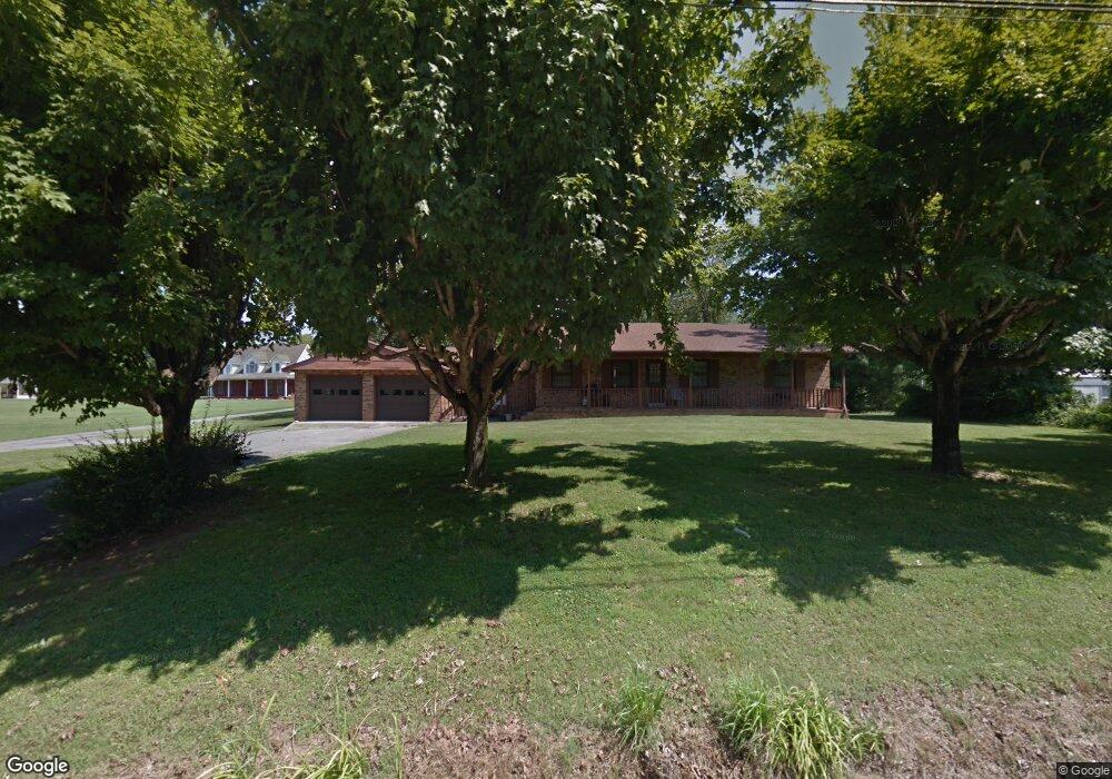
6647 Nashville Hwy Baxter, TN 38544
Estimated Value: $272,459 - $299,000
--
Bed
2
Baths
1,575
Sq Ft
$184/Sq Ft
Est. Value
About This Home
This home is located at 6647 Nashville Hwy, Baxter, TN 38544 and is currently estimated at $289,365, approximately $183 per square foot. 6647 Nashville Hwy is a home located in Putnam County with nearby schools including Baxter Primary School, Cornerstone Elementary School, and Upperman Middle School.
Ownership History
Date
Name
Owned For
Owner Type
Purchase Details
Closed on
Apr 21, 2025
Sold by
Wilson Barry W and Wilson Dianne C
Bought by
Wilson Barry W and Wilson Dianne C
Current Estimated Value
Purchase Details
Closed on
May 10, 2019
Sold by
Wilson Ronnie C
Bought by
Wilson Ronald Craig and Wilson Thresa D
Purchase Details
Closed on
Sep 8, 1998
Sold by
Wilson Ronald C and Wilson Thresa
Bought by
Farris Robert S and Farris Tracy
Purchase Details
Closed on
Aug 25, 1998
Sold by
Clarence Wilson
Bought by
Wilson Ronald C and Wilson Thresa
Purchase Details
Closed on
Jun 6, 1996
Sold by
Clarence Wilson
Bought by
Robert Farris and Robert Tracy
Purchase Details
Closed on
Jun 23, 1964
Bought by
Wilson Clarence and Wilson Louise
Purchase Details
Closed on
Oct 1, 1963
Create a Home Valuation Report for This Property
The Home Valuation Report is an in-depth analysis detailing your home's value as well as a comparison with similar homes in the area
Home Values in the Area
Average Home Value in this Area
Purchase History
| Date | Buyer | Sale Price | Title Company |
|---|---|---|---|
| Wilson Barry W | -- | None Listed On Document | |
| Wilson Barry W | -- | None Listed On Document | |
| Wilson Ronald Craig | -- | -- | |
| Farris Robert S | -- | -- | |
| Wilson Ronald C | -- | -- | |
| Robert Farris | -- | -- | |
| Wilson Clarence | -- | -- | |
| -- | -- | -- |
Source: Public Records
Tax History Compared to Growth
Tax History
| Year | Tax Paid | Tax Assessment Tax Assessment Total Assessment is a certain percentage of the fair market value that is determined by local assessors to be the total taxable value of land and additions on the property. | Land | Improvement |
|---|---|---|---|---|
| 2024 | $1,236 | $46,475 | $9,975 | $36,500 |
| 2023 | $1,236 | $46,475 | $9,975 | $36,500 |
| 2022 | $1,149 | $46,475 | $9,975 | $36,500 |
| 2021 | $1,077 | $43,575 | $9,975 | $33,600 |
| 2020 | $863 | $43,575 | $9,975 | $33,600 |
| 2019 | $863 | $29,500 | $4,775 | $24,725 |
| 2018 | $859 | $31,475 | $6,750 | $24,725 |
| 2017 | $859 | $31,475 | $6,750 | $24,725 |
| 2016 | $859 | $31,475 | $6,750 | $24,725 |
| 2015 | $883 | $31,475 | $6,750 | $24,725 |
| 2014 | $889 | $31,688 | $0 | $0 |
Source: Public Records
Map
Nearby Homes
- 6655 Nashville Hwy
- 6739 Nashville Hwy
- 6449 Nashville Hwy
- 6753 Nashville Hwy
- 426 Pine Grove Rd
- 1360 Dunavin Dr
- 1310 Main St
- 1395 Dunavin Dr
- 1387 Dunavin Dr
- 1365 Main St
- 1296 Main St
- 1359 Dunavin Dr
- 1351 Main St
- 6950 Nashville Hwy
- 0 Highway 56 Unit RTC2449258
- 1274 Main St
- 1297 Main St
- 545 Pine Grove Rd
- 1262 Main St
- 9317 Dobbs Cemetart