Estimated Value: $335,000 - $383,000
3
Beds
2
Baths
1,657
Sq Ft
$215/Sq Ft
Est. Value
About This Home
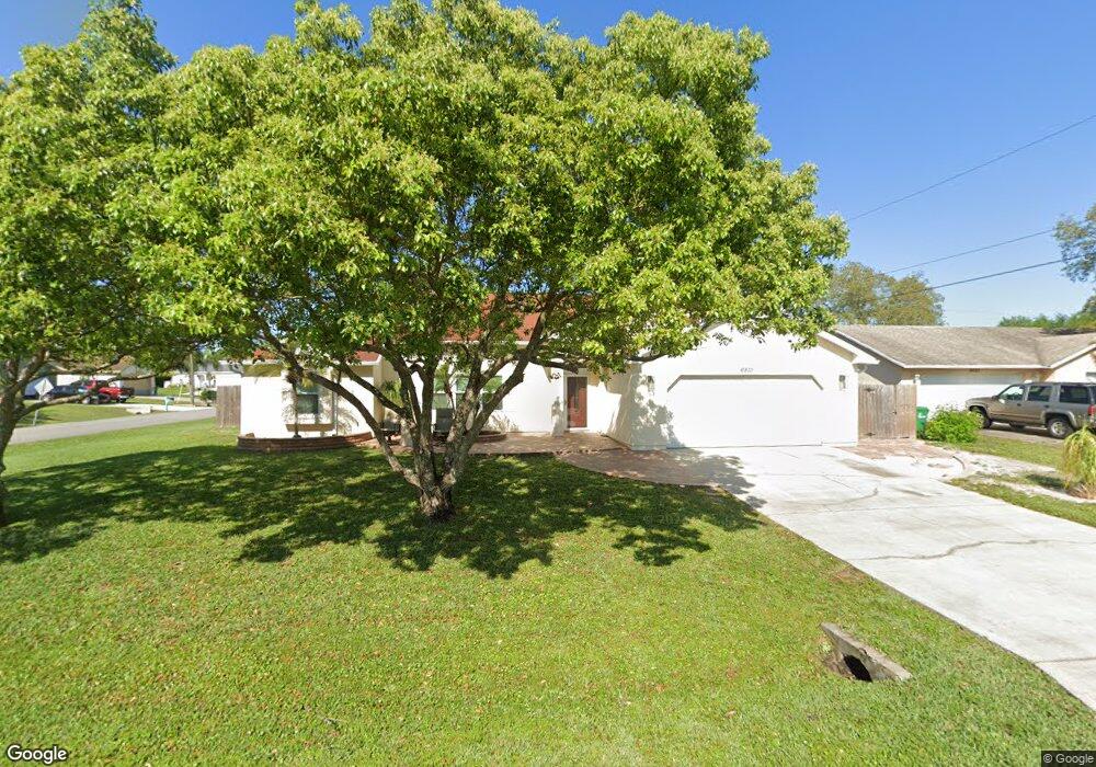
This home is located at 6810 Cairo Rd, Cocoa, FL 32927 and is currently estimated at $356,158, approximately $214 per square foot. 6810 Cairo Rd is a home located in Brevard County with nearby schools including Enterprise Elementary School, Space Coast Junior/Senior High School, and Sculptor Charter School.
Ownership History
Date
Name
Owned For
Owner Type
Purchase Details
Closed on
Aug 29, 2001
Sold by
Adriano Abundio F and Adriano Sandra A
Bought by
Lucas John Russell and Lucas Michelle L
Current Estimated Value
Home Financials for this Owner
Home Financials are based on the most recent Mortgage that was taken out on this home.
Original Mortgage
$114,098
Outstanding Balance
$44,784
Interest Rate
7.08%
Estimated Equity
$311,374
Create a Home Valuation Report for This Property
The Home Valuation Report is an in-depth analysis detailing your home's value as well as a comparison with similar homes in the area
Home Values in the Area
Average Home Value in this Area
Purchase History
| Date | Buyer | Sale Price | Title Company |
|---|---|---|---|
| Lucas John Russell | $115,000 | -- |
Source: Public Records
Mortgage History
| Date | Status | Borrower | Loan Amount |
|---|---|---|---|
| Open | Lucas John Russell | $114,098 |
Source: Public Records
Tax History
| Year | Tax Paid | Tax Assessment Tax Assessment Total Assessment is a certain percentage of the fair market value that is determined by local assessors to be the total taxable value of land and additions on the property. | Land | Improvement |
|---|---|---|---|---|
| 2025 | $1,829 | $149,020 | -- | -- |
| 2024 | $1,790 | $133,180 | -- | -- |
| 2023 | $1,790 | $129,310 | $0 | $0 |
| 2022 | $1,672 | $125,550 | $0 | $0 |
| 2021 | $1,686 | $121,900 | $0 | $0 |
| 2020 | $1,627 | $120,220 | $0 | $0 |
| 2019 | $2,722 | $169,170 | $35,000 | $134,170 |
| 2018 | $2,590 | $156,240 | $27,000 | $129,240 |
| 2017 | $2,477 | $142,630 | $24,000 | $118,630 |
| 2016 | $2,333 | $124,120 | $18,000 | $106,120 |
| 2015 | $2,231 | $103,930 | $15,000 | $88,930 |
| 2014 | $2,053 | $94,490 | $11,000 | $83,490 |
Source: Public Records
Map
Nearby Homes
- 6815 Bryant Rd
- 6760 Cairo Rd
- 7065 Hundred Acre Dr
- 6615 Dock Ave
- 5555 Brandon St
- 6990 Bryant Rd
- 5155 Mayflower St
- 5165 Patricia St
- 5075 Carter St
- 00 Unknown
- 6450 Ember Ave
- 6581 Bancroft Ave
- 5080 Mayflower St
- 6620 Grissom Pkwy
- 5680 Brandon St
- 7230 Venus Ave
- 6481 La Brea Ave
- 5200 Frisco St
- 7045 Grissom Pkwy
- 0000 Grissom Pkwy
Your Personal Tour Guide
Ask me questions while you tour the home.