Estimated Value: $375,000 - $468,000
3
Beds
3
Baths
1,664
Sq Ft
$252/Sq Ft
Est. Value
About This Home
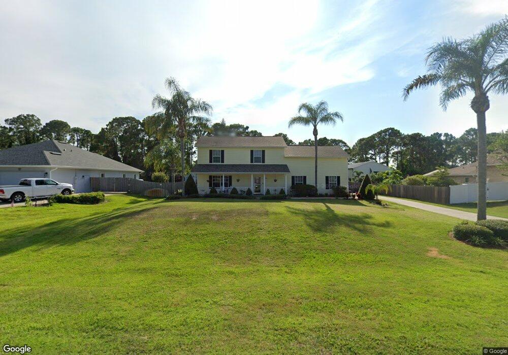
This home is located at 6820 Hundred Acre Dr, Cocoa, FL 32927 and is currently estimated at $419,437, approximately $252 per square foot. 6820 Hundred Acre Dr is a home located in Brevard County with nearby schools including Enterprise Elementary School, Space Coast Junior/Senior High School, and East Atlantic Prep of Brevard County.
Ownership History
Date
Name
Owned For
Owner Type
Purchase Details
Closed on
Oct 24, 1997
Sold by
Vanderlind Gina
Bought by
Gruhler George F and Gruhler Tonda L
Current Estimated Value
Purchase Details
Closed on
Dec 29, 1993
Sold by
Romar Homes Inc
Bought by
Vanderlind Gina
Home Financials for this Owner
Home Financials are based on the most recent Mortgage that was taken out on this home.
Original Mortgage
$9,600
Interest Rate
7.25%
Create a Home Valuation Report for This Property
The Home Valuation Report is an in-depth analysis detailing your home's value as well as a comparison with similar homes in the area
Home Values in the Area
Average Home Value in this Area
Purchase History
| Date | Buyer | Sale Price | Title Company |
|---|---|---|---|
| Gruhler George F | $14,500 | -- | |
| Vanderlind Gina | $12,000 | -- |
Source: Public Records
Mortgage History
| Date | Status | Borrower | Loan Amount |
|---|---|---|---|
| Previous Owner | Vanderlind Gina | $9,600 |
Source: Public Records
Tax History
| Year | Tax Paid | Tax Assessment Tax Assessment Total Assessment is a certain percentage of the fair market value that is determined by local assessors to be the total taxable value of land and additions on the property. | Land | Improvement |
|---|---|---|---|---|
| 2025 | $2,104 | $161,280 | -- | -- |
| 2024 | $2,064 | $156,740 | -- | -- |
| 2023 | $2,064 | $152,180 | $0 | $0 |
| 2022 | $1,929 | $147,750 | $0 | $0 |
| 2021 | $1,956 | $143,450 | $0 | $0 |
| 2020 | $1,901 | $141,470 | $0 | $0 |
| 2019 | $1,843 | $138,290 | $0 | $0 |
| 2018 | $1,843 | $135,720 | $0 | $0 |
| 2017 | $1,853 | $132,930 | $0 | $0 |
| 2016 | $1,870 | $130,200 | $32,000 | $98,200 |
| 2015 | $1,912 | $129,300 | $32,000 | $97,300 |
| 2014 | $1,920 | $128,280 | $32,000 | $96,280 |
Source: Public Records
Map
Nearby Homes
- 5680 Brandon St
- 5555 Brandon St
- 6665 Addie Ave
- 6581 Bancroft Ave
- 7065 Hundred Acre Dr
- 6574 Bamboo Ave
- 6105 Banyan St
- 6615 Dock Ave
- 7200 Oakwood Ave
- 6545 Addie Ave
- 6135 Allmont St
- 6481 La Brea Ave
- 6815 Bryant Rd
- 6990 Bryant Rd
- 6470 Bamboo Ave
- 6460 Homestead Ave
- 6760 Cairo Rd
- 0 Aruin St Unit 1222557
- 7230 Venus Ave
- 5680 Banos Ave
- 6810 Hundred Acre Dr
- 6830 Hundred Acre Dr
- 6845 Hundred Acre Dr
- 6800 Hundred Acre Dr
- 6840 Hundred Acre Dr
- 6855 Hundred Acre Dr
- 6790 Hundred Acre Dr
- 6850 Hundred Acre Dr
- 6775 Hundred Acre Dr
- 6860 Hundred Acre Dr
- 6865 Hundred Acre Dr
- 6780 Hundred Acre Dr
- 5735 Brandon St
- 6765 Hundred Acre Dr
- 5725 Brandon St
- 6870 Hundred Acre Dr
- 5715 Brandon St
- 6755 Hundred Acre Dr
- 6875 Hundred Acre Dr
- 6782 Acre Woods Ct
Your Personal Tour Guide
Ask me questions while you tour the home.