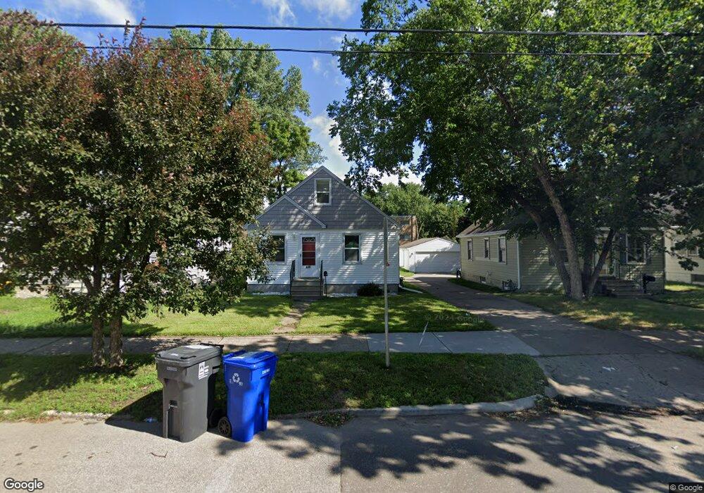
689 Front Ave Saint Paul, MN 55103
Como Park NeighborhoodEstimated Value: $290,000 - $314,000
3
Beds
2
Baths
1,584
Sq Ft
$190/Sq Ft
Est. Value
About This Home
This home is located at 689 Front Ave, Saint Paul, MN 55103 and is currently estimated at $300,817, approximately $189 per square foot. 689 Front Ave is a home located in Ramsey County with nearby schools including Como Park Elementary School, Murray Middle School, and Como Park Senior High School.
Ownership History
Date
Name
Owned For
Owner Type
Purchase Details
Closed on
Feb 11, 2021
Sold by
L Anderson Investments Llc
Bought by
Khang Neng and Lor Yer
Current Estimated Value
Home Financials for this Owner
Home Financials are based on the most recent Mortgage that was taken out on this home.
Original Mortgage
$180,000
Outstanding Balance
$160,990
Interest Rate
2.7%
Mortgage Type
New Conventional
Estimated Equity
$139,827
Purchase Details
Closed on
Jul 10, 2020
Sold by
Bailey Jaclyn Jaclyn
Home Financials for this Owner
Home Financials are based on the most recent Mortgage that was taken out on this home.
Interest Rate
3.03%
Create a Home Valuation Report for This Property
The Home Valuation Report is an in-depth analysis detailing your home's value as well as a comparison with similar homes in the area
Home Values in the Area
Average Home Value in this Area
Purchase History
| Date | Buyer | Sale Price | Title Company |
|---|---|---|---|
| Khang Neng | $225,000 | Titlesmart Inc | |
| -- | $125,000 | -- | |
| Khang Neng Neng | $225,000 | -- |
Source: Public Records
Mortgage History
| Date | Status | Borrower | Loan Amount |
|---|---|---|---|
| Open | Khang Neng | $180,000 | |
| Previous Owner | -- | -- | |
| Closed | Khang Neng Neng | $180,000 |
Source: Public Records
Tax History Compared to Growth
Tax History
| Year | Tax Paid | Tax Assessment Tax Assessment Total Assessment is a certain percentage of the fair market value that is determined by local assessors to be the total taxable value of land and additions on the property. | Land | Improvement |
|---|---|---|---|---|
| 2025 | $4,342 | $301,600 | $35,000 | $266,600 |
| 2023 | $4,342 | $280,200 | $35,000 | $245,200 |
| 2022 | $2,108 | $276,400 | $35,000 | $241,400 |
| 2021 | $2,728 | $147,600 | $35,000 | $112,600 |
| 2020 | $2,448 | $179,000 | $35,000 | $144,000 |
| 2019 | $2,176 | $162,700 | $35,000 | $127,700 |
| 2018 | $1,868 | $145,700 | $35,000 | $110,700 |
| 2017 | $1,756 | $132,500 | $28,000 | $104,500 |
| 2016 | $1,748 | $0 | $0 | $0 |
| 2015 | $1,880 | $126,600 | $28,000 | $98,600 |
| 2014 | $1,644 | $0 | $0 | $0 |
Source: Public Records
Map
Nearby Homes
- 705 Como Ave
- 740 Como Ave
- 352 Como Ave
- 1063 Dale St N
- 569 Hatch Ave
- 1049 Kent St
- 989 Barrett St
- 552 Burgess St
- 895 Front Ave
- 1038 Colne St
- 766 Maryland Ave W
- 1104 MacKubin St
- 933 Front Ave
- 1084 Ryde St
- 1005 Como Blvd E
- 1241 Maywood St
- 631 Van Buren Ave
- 751 Van Buren Ave
- 1165 Norton St
- 646 Van Buren Ave
- 693 Front Ave
- 685 Front Ave
- 681 Front Ave
- 697 Front Ave
- 981 St Albans St N Unit 102
- 981 St Albans St N Unit 301
- 981 St Albans St N Unit 103
- 705 Front Ave
- 677 Front Ave
- 675 Front Ave
- 995 St Albans St N Unit 108
- 995 St Albans St N Unit 307
- 671 Front Ave
- 672 Como Ave
- 668 Como Ave
- 665 Front Ave
- 664 Como Ave
- 670 Front Ave
- 668 Front Ave Unit 2
- 664 Front Ave Unit 1