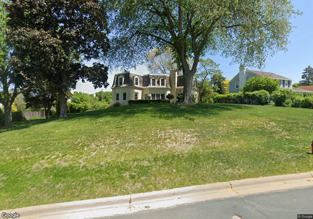
7 Beebe Ave Saint Paul, MN 55118
Estimated Value: $592,966 - $840,000
4
Beds
3
Baths
2,416
Sq Ft
$281/Sq Ft
Est. Value
About This Home
This home is located at 7 Beebe Ave, Saint Paul, MN 55118 and is currently estimated at $677,742, approximately $280 per square foot. 7 Beebe Ave is a home located in Dakota County with nearby schools including Somerset Elementary School, Heritage E-STEM Magnet School, and Two Rivers High School.
Ownership History
Date
Name
Owned For
Owner Type
Purchase Details
Closed on
Sep 1, 2017
Sold by
Wold Jeffrey M and Strand Rebecca L
Bought by
Mcfaul Bradley F and Mcfaul Laurie C
Current Estimated Value
Home Financials for this Owner
Home Financials are based on the most recent Mortgage that was taken out on this home.
Original Mortgage
$423,750
Outstanding Balance
$354,051
Interest Rate
3.92%
Mortgage Type
New Conventional
Estimated Equity
$323,691
Purchase Details
Closed on
Feb 23, 2001
Sold by
Weinberg James R
Bought by
Wold Jeffrey M and Strand Rebecca L
Create a Home Valuation Report for This Property
The Home Valuation Report is an in-depth analysis detailing your home's value as well as a comparison with similar homes in the area
Home Values in the Area
Average Home Value in this Area
Purchase History
| Date | Buyer | Sale Price | Title Company |
|---|---|---|---|
| Mcfaul Bradley F | $565,000 | Minnesota Title | |
| Wold Jeffrey M | $349,900 | -- |
Source: Public Records
Mortgage History
| Date | Status | Borrower | Loan Amount |
|---|---|---|---|
| Open | Mcfaul Bradley F | $423,750 |
Source: Public Records
Tax History
| Year | Tax Paid | Tax Assessment Tax Assessment Total Assessment is a certain percentage of the fair market value that is determined by local assessors to be the total taxable value of land and additions on the property. | Land | Improvement |
|---|---|---|---|---|
| 2024 | $5,078 | $558,800 | $187,900 | $370,900 |
| 2023 | $5,078 | $538,400 | $183,700 | $354,700 |
| 2022 | $4,274 | $510,700 | $183,300 | $327,400 |
| 2021 | $4,222 | $427,500 | $159,400 | $268,100 |
| 2020 | $4,486 | $416,600 | $151,800 | $264,800 |
| 2019 | $4,165 | $426,500 | $144,500 | $282,000 |
| 2018 | $3,827 | $378,700 | $135,000 | $243,700 |
| 2017 | $4,199 | $362,400 | $128,600 | $233,800 |
| 2016 | $4,147 | $356,800 | $122,500 | $234,300 |
| 2015 | $4,244 | $348,838 | $120,646 | $228,192 |
| 2014 | -- | $343,388 | $113,676 | $229,712 |
| 2013 | -- | $333,796 | $110,023 | $223,773 |
Source: Public Records
Map
Nearby Homes
- 1248 Delaware Ave
- 8 Dorset Rd
- 1072 Delaware Ave
- 625 Ivy Falls Ave
- 1280 Dodd Rd
- 1018 Delaware Ave
- 622 Maple Park Dr
- 480 Emerson Ave W
- 426 Emerson Ave W
- 641 Sibley Memorial Hwy
- 130x Dodd Rd
- 967 Ohio St
- 974 Ohio St
- 396 Thompson Ave W
- 902 Dodd Rd
- 822 Smith Ave S
- 242 Annapolis St W
- 763 Cherokee Ave
- 973 Bidwell St
- 342 Curtice St W
Your Personal Tour Guide
Ask me questions while you tour the home.