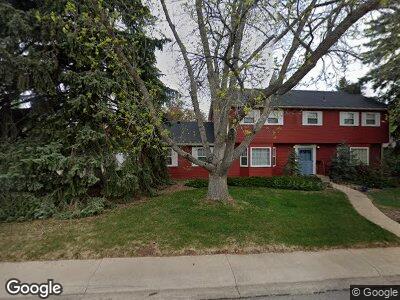
700 Birky Place Fort Collins, CO 80526
Sheely Addition NeighborhoodEstimated Value: $757,707 - $989,000
4
Beds
3
Baths
2,678
Sq Ft
$321/Sq Ft
Est. Value
About This Home
This home is located at 700 Birky Place, Fort Collins, CO 80526 and is currently estimated at $859,677, approximately $321 per square foot. 700 Birky Place is a home located in Larimer County with nearby schools including Bennett Elementary School, Blevins Middle School, and Rocky Mountain High School.
Ownership History
Date
Name
Owned For
Owner Type
Purchase Details
Closed on
Dec 4, 2015
Sold by
Shambro Lisa M
Bought by
Gillett Lewis C
Current Estimated Value
Purchase Details
Closed on
May 16, 1996
Sold by
Johnson Frank T
Bought by
Johnson Mary Jo
Create a Home Valuation Report for This Property
The Home Valuation Report is an in-depth analysis detailing your home's value as well as a comparison with similar homes in the area
Home Values in the Area
Average Home Value in this Area
Purchase History
| Date | Buyer | Sale Price | Title Company |
|---|---|---|---|
| Gillett Lewis C | -- | None Available | |
| Johnson Mary Jo | -- | -- |
Source: Public Records
Mortgage History
| Date | Status | Borrower | Loan Amount |
|---|---|---|---|
| Previous Owner | Johnson Frank T | $25,107 | |
| Previous Owner | Dennison Cynthia J | $9,283 | |
| Previous Owner | Johnson Mary Jo | $100,000 | |
| Previous Owner | Johnson Mary Jo | $21,293 | |
| Previous Owner | Johnson Mary Jo | $78,706 | |
| Previous Owner | Johnson Frank T | $125,000 |
Source: Public Records
Tax History Compared to Growth
Tax History
| Year | Tax Paid | Tax Assessment Tax Assessment Total Assessment is a certain percentage of the fair market value that is determined by local assessors to be the total taxable value of land and additions on the property. | Land | Improvement |
|---|---|---|---|---|
| 2025 | $4,131 | $53,433 | $3,685 | $49,748 |
| 2024 | $3,930 | $53,433 | $3,685 | $49,748 |
| 2022 | $3,487 | $43,876 | $3,823 | $40,053 |
| 2021 | $3,524 | $45,138 | $3,933 | $41,205 |
| 2020 | $3,220 | $41,571 | $3,933 | $37,638 |
| 2019 | $3,234 | $41,571 | $3,933 | $37,638 |
| 2018 | $2,231 | $31,680 | $3,960 | $27,720 |
| 2017 | $2,223 | $31,680 | $3,960 | $27,720 |
| 2016 | $2,042 | $30,328 | $4,378 | $25,950 |
| 2015 | $2,027 | $30,330 | $4,380 | $25,950 |
| 2014 | $1,679 | $26,370 | $4,380 | $21,990 |
Source: Public Records
Map
Nearby Homes
- 1928 Sheely Dr
- 635 W Prospect Rd
- 1000 W Prospect Rd
- 1906 Waters Edge St Unit F
- 1935 Waters Edge St Unit C
- 1935 Waters Edge St Unit A
- 1021 Rolland Moore Dr Unit G
- 1020 Rolland Moore Dr Unit 2D
- 1212 Springfield Dr
- 1640 Remington St
- 1636 Remington St
- 1100 Evenstar Ct
- 1317 Lakewood Dr
- 1820 Indian Meadows Ln
- 515 S Shields St
- 0 S Shields St
- 1221 University Ave Unit B201
- 2025 Mathews St Unit 3
- 2025 Mathews St Unit I2
- 1705 Heatheridge Rd Unit G102