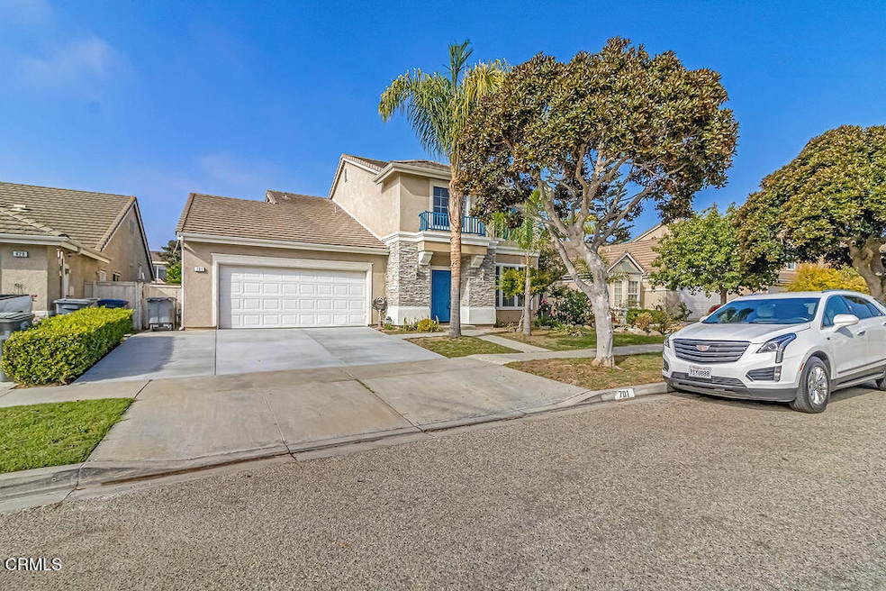


701 Olivia Dr Oxnard, CA 93030
West Village NeighborhoodEstimated payment $5,071/month
Highlights
- No HOA
- Park
- Central Heating
- 3 Car Attached Garage
- Laundry Room
- Fenced
About This Home
Priced for a Quick Sale! Spacious 4-Bedroom Home in Desirable North Oxnard!Welcome to Rancho de La Rosa, one of North Oxnard's most sought-after neighborhoods! This spacious 4-bedroom, 3-car-garage home offers incredible potential and has been recently remodeled with many important updates already completed -- including new flooring, fresh interior and exterior paint, and a newly redone driveway that enhances the home's curb appeal.The kitchen features generous counter space and cabinetry, offering an excellent foundation for your dream kitchen design. The seller intentionally left the choice of new appliances to the buyer, allowing you to select the style and brand that best fit your taste.Inside, enjoy a bright, open layout that flows easily between the living, dining, and family rooms -- ideal for both entertaining and everyday comfort. Upstairs, the four spacious bedrooms include a large primary bedroom filled with natural light and an en-suite bathroom.The backyard offers excellent size and potential, ready for the new owner to transform it into a dream outdoor retreat. With its generous layout, the yard also offers ADU potential -- perfect for extended family, a guest unit, or possible rental income (buyer to verify).This home is priced for a quick sale and will be sold as-is, giving buyers the chance to add their own finishing touches and make it truly shine.Conveniently, located near parks, schools, restaurants, shopping, and the 101 freeway, and just minutes from Mandalay Beach, this home combines value, space, and opportunity in one great package.Must see to appreciate!
Listing Agent
Win Win Realty Brokerage Email: knguyen67@yahoo.com License #01383309 Listed on: 11/04/2025
Home Details
Home Type
- Single Family
Year Built
- Built in 1998
Lot Details
- 5,662 Sq Ft Lot
- Fenced
- Fence is in fair condition
- Sprinkler System
Parking
- 3 Car Attached Garage
- Parking Available
Home Design
- Planned Development
Interior Spaces
- 2,167 Sq Ft Home
- 2-Story Property
- Family Room with Fireplace
- Gas Cooktop
Bedrooms and Bathrooms
- 4 Bedrooms
Laundry
- Laundry Room
- Washer and Gas Dryer Hookup
Utilities
- Central Heating
Listing and Financial Details
- Assessor Parcel Number 2150040295
Community Details
Overview
- No Home Owners Association
- Rancho De La Rosa 1 471401 Subdivision
Recreation
- Park
Map
Home Values in the Area
Average Home Value in this Area
Tax History
| Year | Tax Paid | Tax Assessment Tax Assessment Total Assessment is a certain percentage of the fair market value that is determined by local assessors to be the total taxable value of land and additions on the property. | Land | Improvement |
|---|---|---|---|---|
| 2025 | $4,586 | $340,079 | $136,027 | $204,052 |
| 2024 | $4,586 | $333,411 | $133,360 | $200,051 |
| 2023 | $4,421 | $326,874 | $130,745 | $196,129 |
| 2022 | $4,280 | $320,465 | $128,181 | $192,284 |
| 2021 | $4,222 | $314,182 | $125,668 | $188,514 |
| 2020 | $4,289 | $310,963 | $124,381 | $186,582 |
| 2019 | $4,167 | $304,867 | $121,943 | $182,924 |
| 2018 | $4,105 | $298,890 | $119,552 | $179,338 |
| 2017 | $3,902 | $293,030 | $117,208 | $175,822 |
| 2016 | $3,769 | $287,285 | $114,910 | $172,375 |
| 2015 | $3,785 | $282,972 | $113,185 | $169,787 |
| 2014 | -- | $277,431 | $110,969 | $166,462 |
Property History
| Date | Event | Price | List to Sale | Price per Sq Ft |
|---|---|---|---|---|
| 11/04/2025 11/04/25 | For Sale | $895,000 | -- | $413 / Sq Ft |
Purchase History
| Date | Type | Sale Price | Title Company |
|---|---|---|---|
| Interfamily Deed Transfer | -- | None Available | |
| Grant Deed | $217,000 | Chicago Title |
Mortgage History
| Date | Status | Loan Amount | Loan Type |
|---|---|---|---|
| Previous Owner | $160,000 | No Value Available |
Source: Ventura County Regional Data Share
MLS Number: V1-33211
APN: 215-0-040-295
Disclaimer: Certain information contained herein is derived from information provided by parties other than Homes.com. All information provided is deemed reliable, but is not guaranteed to be accurate and should be independently verified.
![]() IDX information is provided exclusively for personal, non-commercial use, and may not be used for any purpose other than to identify prospective properties consumers may be interested in purchasing. Information is deemed reliable but not guaranteed.
IDX information is provided exclusively for personal, non-commercial use, and may not be used for any purpose other than to identify prospective properties consumers may be interested in purchasing. Information is deemed reliable but not guaranteed.
- 517 Orilla Walk
- 1501 Morris St
- 1440 Morris St
- 400 N Hayes Ave
- 136 N Garfield Ave
- 1902 Ribera Dr Unit 86
- 1930 Ribera Dr
- 211 Featherstone St
- 403 E 2nd St
- 2030 Ocaso Place
- 1930 Del Amo Way
- 407 Magnolia Ave
- 208 Bolero Ln
- 800 S A St
- 630 W Roderick Ave
- 2108 Avila Place
- 633 Meta St
- 155 E 7th St
- 307 N F St Unit 102
- 207 Hermano Trail
- 728 Navito Way
- 1325 Juanita Ave
- 123 S Juanita Ave
- 1500 Tulipan Cir
- 2060 Zocolo St
- 1750 Montevina Cir
- 60 Princeton Ave
- 723 W Robert Ave
- 333 N F St
- 443 Occidental Dr Unit 4
- 2400-2444 Alvarado St
- 410 S G St
- 300 W 9th St
- 1101 W 2nd St
- 820 S E St
- 1150 W 1st St
- 1170 W 1st St
- 1201 Gonzales Ave
- 1301 Kingswood Way Unit 2
- 200 Orchard Place
