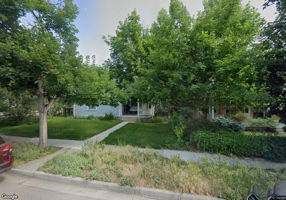
705 Maxwell Ave Boulder, CO 80304
Mapleton Hill NeighborhoodEstimated Value: $1,357,000 - $1,653,000
3
Beds
2
Baths
1,427
Sq Ft
$1,056/Sq Ft
Est. Value
About This Home
This home is located at 705 Maxwell Ave, Boulder, CO 80304 and is currently estimated at $1,507,534, approximately $1,056 per square foot. 705 Maxwell Ave is a home located in Boulder County with nearby schools including Whittier Elementary School, Casey Middle School, and Boulder High School.
Ownership History
Date
Name
Owned For
Owner Type
Purchase Details
Closed on
Jan 25, 1994
Sold by
Dickinson Richard V
Bought by
King Deborah R
Current Estimated Value
Home Financials for this Owner
Home Financials are based on the most recent Mortgage that was taken out on this home.
Original Mortgage
$125,000
Interest Rate
7.16%
Purchase Details
Closed on
Apr 16, 1969
Bought by
King Deborah R
Create a Home Valuation Report for This Property
The Home Valuation Report is an in-depth analysis detailing your home's value as well as a comparison with similar homes in the area
Home Values in the Area
Average Home Value in this Area
Purchase History
| Date | Buyer | Sale Price | Title Company |
|---|---|---|---|
| King Deborah R | $160,000 | -- | |
| King Deborah R | -- | -- | |
| King Deborah R | -- | -- | |
| King Deborah R | -- | -- | |
| King Deborah R | -- | -- |
Source: Public Records
Mortgage History
| Date | Status | Borrower | Loan Amount |
|---|---|---|---|
| Closed | King Deborah R | $125,000 |
Source: Public Records
Tax History
| Year | Tax Paid | Tax Assessment Tax Assessment Total Assessment is a certain percentage of the fair market value that is determined by local assessors to be the total taxable value of land and additions on the property. | Land | Improvement |
|---|---|---|---|---|
| 2025 | $8,817 | $98,476 | $88,628 | $9,848 |
| 2024 | $8,817 | $98,476 | $88,628 | $9,848 |
| 2023 | $8,664 | $107,026 | $99,640 | $11,071 |
| 2022 | $7,038 | $82,740 | $71,919 | $10,821 |
| 2021 | $6,711 | $85,121 | $73,988 | $11,133 |
| 2020 | $6,348 | $80,080 | $64,064 | $16,016 |
| 2019 | $6,864 | $80,080 | $64,064 | $16,016 |
| 2018 | $5,868 | $67,687 | $54,144 | $13,543 |
| 2017 | $5,685 | $74,831 | $59,859 | $14,972 |
| 2016 | $5,652 | $65,296 | $46,407 | $18,889 |
| 2015 | $5,352 | $45,905 | $24,039 | $21,866 |
| 2014 | $3,860 | $45,905 | $24,039 | $21,866 |
Source: Public Records
Map
Nearby Homes
- 643 Mapleton Ave
- 827 Maxwell Ave Unit E
- 545 Mapleton Ave
- 604 Mapleton Ave
- 900 Portland Place
- 745 Highland Ave
- 946 Portland Place
- 653 Dewey Ave
- 534 Dewey Ave
- 2449 5th St
- 1020 Portland Place
- 2409 5th St
- 1009 Portland Place
- 613 Pine St
- 1031 Portland Place Unit 4
- 1111 Maxwell Ave Unit 109
- 1111 Maxwell Ave Unit 105
- 815 Alpine Ave Unit 2
- 515 Alpine Ave
- 934 Spruce St
- 707 Maxwell Ave
- 801 Maxwell Ave
- 665 Maxwell Ave
- 2515 7th St
- 805 Maxwell Ave
- 661 Maxwell Ave
- 704 Concord Ave
- 734 Maxwell Ave
- 710 Concord Ave Unit A
- 710 Concord Ave Unit B
- 710 Concord Ave
- 736 Maxwell Ave
- 716 Maxwell Ave
- 2535 7th St
- 815 Maxwell Ave Unit 4
- 815 Maxwell Ave Unit 3
- 815 Maxwell Ave Unit 2
- 815 Maxwell Ave Unit 1
- 655 Maxwell Ave
- 2448 7th St
Your Personal Tour Guide
Ask me questions while you tour the home.