


71 Norton Ave Cranston, RI 02920
Meshanticut NeighborhoodEstimated payment $4,477/month
Highlights
- 0.57 Acre Lot
- Cape Cod Architecture
- Public Transportation
- Cranston High School West Rated 9+
- Wood Flooring
- Shops
About This Home
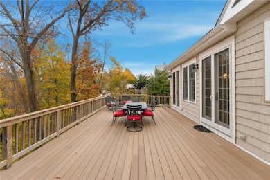
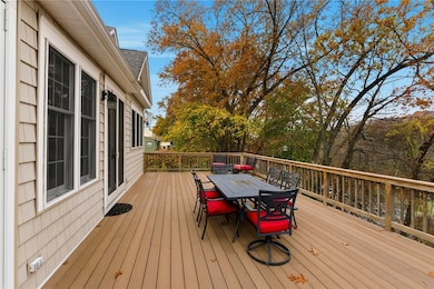
Welcome to 71 Norton Avenue, where timeless design meets modern comfort. Built in 2009, this stunning 3-bedroom, 2.5-bath Colonial offers over 2,554 square feet of thoughtfully designed living space, set in one of Cranston's most desirable and scenic neighborhoods. Open and inviting floor plan that's perfect for today's lifestyle. The spacious living room features a gas fireplace with a beautiful stone surround, creating a warm and elegant focal point for family gatherings or quiet evenings at home. Large windows fill the space with natural light and frame breathtaking views of Meshanticut Brook and Angles Pond. The kitchen and dining area flow seamlessly together, ideal for entertaining. Modern cabinetry, ample counter space, and direct access to the deck, where you can relax with morning coffee or host summer dinners overlooking the water, private primary suite, walk-out basement, central air conditioning, hydro-air heating, just steps from beautiful Meshanticut Park, minutes from Garden City Center, scenic views, modern amenities, and a prime location. Call today for your private showing!
Home Details
Home Type
- Single Family
Est. Annual Taxes
- $7,397
Year Built
- Built in 2009
Lot Details
- 0.57 Acre Lot
Home Design
- Cape Cod Architecture
- Colonial Architecture
- Concrete Perimeter Foundation
- Clapboard
- Plaster
Interior Spaces
- 2-Story Property
- Fireplace Features Masonry
- Wood Flooring
Bedrooms and Bathrooms
- 3 Bedrooms
Unfinished Basement
- Basement Fills Entire Space Under The House
- Interior and Exterior Basement Entry
Parking
- 4 Parking Spaces
- No Garage
Utilities
- Forced Air Heating and Cooling System
- Heating System Uses Gas
- 200+ Amp Service
- Gas Water Heater
Community Details
- Shops
- Restaurant
- Public Transportation
Listing and Financial Details
- Legal Lot and Block 24 / 3
- Assessor Parcel Number 71NORTONAVCRAN
Map
Home Values in the Area
Average Home Value in this Area
Tax History
| Year | Tax Paid | Tax Assessment Tax Assessment Total Assessment is a certain percentage of the fair market value that is determined by local assessors to be the total taxable value of land and additions on the property. | Land | Improvement |
|---|---|---|---|---|
| 2025 | $7,397 | $532,900 | $111,800 | $421,100 |
| 2024 | $7,253 | $532,900 | $111,800 | $421,100 |
| 2023 | $7,452 | $394,300 | $73,500 | $320,800 |
| 2022 | $7,298 | $394,300 | $73,500 | $320,800 |
| 2021 | $7,097 | $394,300 | $73,500 | $320,800 |
| 2020 | $6,555 | $315,600 | $70,000 | $245,600 |
| 2019 | $6,555 | $315,600 | $70,000 | $245,600 |
| 2018 | $6,404 | $315,600 | $70,000 | $245,600 |
| 2017 | $5,992 | $261,200 | $63,000 | $198,200 |
| 2016 | $5,774 | $257,200 | $59,000 | $198,200 |
| 2015 | $5,774 | $257,200 | $59,000 | $198,200 |
| 2014 | $6,034 | $264,200 | $59,000 | $205,200 |
Property History
| Date | Event | Price | List to Sale | Price per Sq Ft |
|---|---|---|---|---|
| 11/13/2025 11/13/25 | For Sale | $734,000 | -- | $178 / Sq Ft |
Purchase History
| Date | Type | Sale Price | Title Company |
|---|---|---|---|
| Joint Tenancy Deed | -- | -- | |
| Deed | -- | -- | |
| Quit Claim Deed | -- | -- | |
| Deed | $40,000 | -- |
Source: State-Wide MLS
MLS Number: 1400116
APN: CRAN-000011-000003-000724
Disclaimer: Certain information contained herein is derived from information provided by parties other than Homes.com. All information provided is deemed reliable, but is not guaranteed to be accurate and should be independently verified.
![]() IDX information is provided exclusively for personal, non-commercial use, and may not be used for any purpose other than to identify prospective properties consumers may be interested in purchasing. Information is deemed reliable but not guaranteed.
IDX information is provided exclusively for personal, non-commercial use, and may not be used for any purpose other than to identify prospective properties consumers may be interested in purchasing. Information is deemed reliable but not guaranteed.
Copyright © 2025 State-Wide MLS, Inc. All rights reserved.
- 65 Oaklawn Ave Unit 75-114
- 65-75 Oaklawn Ave
- 30 Oaklawn Ave
- 91-111 Oaklawn Ave
- 24 Elmhurst Ave Unit 2
- 108 Phenix Ave Unit 2
- 217 Oaklawn Ave
- 83 Phenix Ave Unit 83
- 444 Meshanticut Valley Pkwy
- 100 Elena St
- 47 Chester Ave
- 15 Florida Ave Unit 2
- 41 Garden City Dr
- 41 Oak St Unit 43
- 430 Meshanticut Valley Pkwy
- 201 Hoffman Ave Unit 25
- 134 Flint Ave
- 630 Oaklawn Ave
- 50 Clemence St Unit 50
- 12 Fortini St Unit 2L
