Estimated Value: $333,000 - $364,000
4
Beds
2
Baths
1,908
Sq Ft
$181/Sq Ft
Est. Value
About This Home
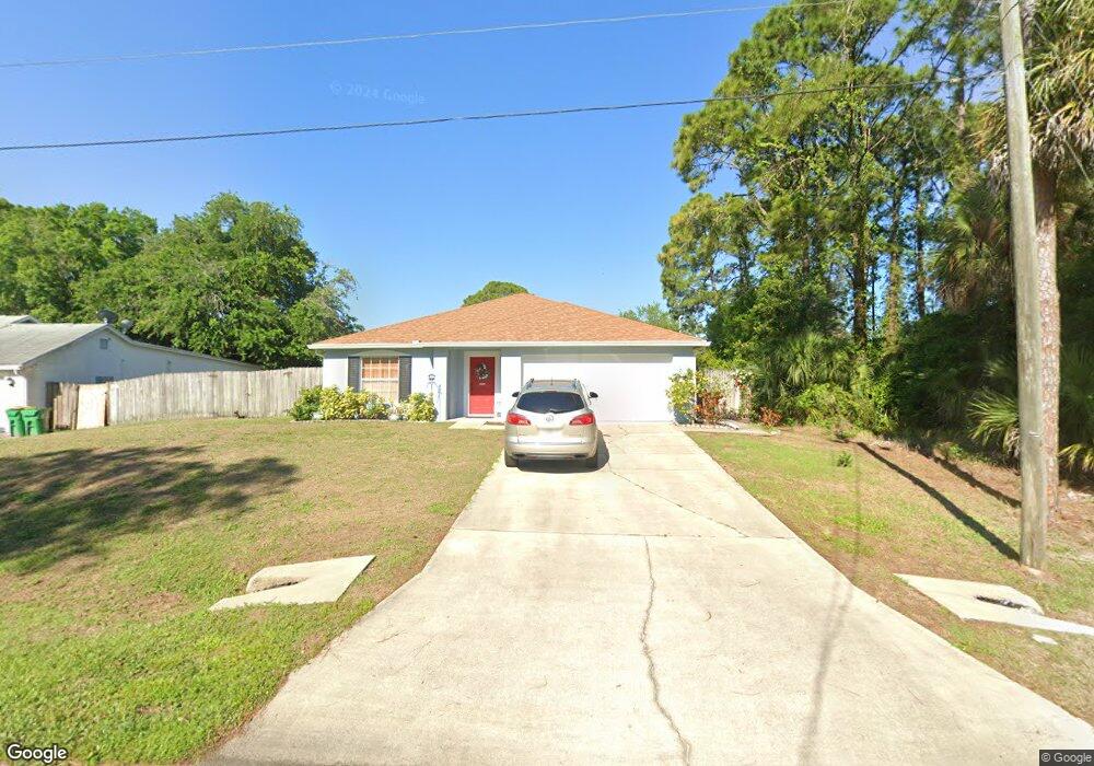
This home is located at 7190 Freeport Rd, Cocoa, FL 32927 and is currently estimated at $345,529, approximately $181 per square foot. 7190 Freeport Rd is a home located in Brevard County with nearby schools including Enterprise Elementary School, Space Coast Junior/Senior High School, and East Atlantic Prep of Brevard County.
Ownership History
Date
Name
Owned For
Owner Type
Purchase Details
Closed on
Oct 7, 2002
Sold by
Holiday Bldr Inc
Bought by
Mcbride Michael G and Mcbride Sandra O
Current Estimated Value
Home Financials for this Owner
Home Financials are based on the most recent Mortgage that was taken out on this home.
Original Mortgage
$86,479
Outstanding Balance
$36,388
Interest Rate
6.21%
Mortgage Type
Purchase Money Mortgage
Estimated Equity
$309,141
Purchase Details
Closed on
May 10, 2002
Sold by
Foskey Gary and Foskey Valarie
Bought by
Holiday Bldr Inc
Purchase Details
Closed on
Sep 12, 1998
Sold by
Reynolds Ansell F and Reynolds Sonia M
Bought by
Poskey Gary and Foskey Valarie
Create a Home Valuation Report for This Property
The Home Valuation Report is an in-depth analysis detailing your home's value as well as a comparison with similar homes in the area
Home Values in the Area
Average Home Value in this Area
Purchase History
| Date | Buyer | Sale Price | Title Company |
|---|---|---|---|
| Mcbride Michael G | $111,600 | -- | |
| Holiday Bldr Inc | -- | -- | |
| Holiday Bldr Inc | $15,000 | -- | |
| Poskey Gary | $12,400 | -- |
Source: Public Records
Mortgage History
| Date | Status | Borrower | Loan Amount |
|---|---|---|---|
| Open | Mcbride Michael G | $86,479 |
Source: Public Records
Tax History
| Year | Tax Paid | Tax Assessment Tax Assessment Total Assessment is a certain percentage of the fair market value that is determined by local assessors to be the total taxable value of land and additions on the property. | Land | Improvement |
|---|---|---|---|---|
| 2025 | $1,360 | $109,980 | -- | -- |
| 2024 | $1,316 | $106,890 | -- | -- |
| 2023 | $1,316 | $103,780 | $0 | $0 |
| 2022 | $1,259 | $100,760 | $0 | $0 |
| 2021 | $1,251 | $97,830 | $0 | $0 |
| 2020 | $1,173 | $96,480 | $0 | $0 |
| 2019 | $1,110 | $94,320 | $0 | $0 |
| 2018 | $1,103 | $92,570 | $0 | $0 |
| 2017 | $1,259 | $90,670 | $0 | $0 |
| 2016 | $1,260 | $88,810 | $18,000 | $70,810 |
| 2015 | $1,274 | $88,200 | $15,000 | $73,200 |
| 2014 | $1,275 | $87,500 | $11,000 | $76,500 |
Source: Public Records
Map
Nearby Homes
- 7200 Oakwood Ave
- 7368 Crepe Myrtle Ct
- 5680 Brandon St
- 7230 Venus Ave
- 7419 Hackberry Rd
- 7429 Hackberry Rd
- 5555 Brandon St
- 7065 Hundred Acre Dr
- 7635 Fringe Place
- 6990 Bryant Rd
- 7606 Fringe Place
- 5303 Yaupon Holly Dr
- 6643 Emil Ave
- 5242 Yaupon Holly Dr
- 6815 Bryant Rd
- 6105 Banyan St
- 5165 Patricia St
- 6581 Bancroft Ave
- 5155 Mayflower St
- 6615 Dock Ave
- 7180 Freeport Rd
- 7210 Freeport Rd
- 12 Lot Freeport
- 7195 Freeport Rd
- 7205 Freeport Rd
- TBD Freeport Rd
- 7162 Freeport Rd
- 7170 Freeport Rd
- 7185 Freeport Rd
- 7215 Freeport Rd
- 7220 Freeport Rd
- 7168 Freeport Rd
- 7190 Kimball Ave
- 7200 Kimball Ave
- 7200 E Kimball
- 7230 Freeport Rd
- 7161 Freeport Rd
- 7164 Freeport Rd
- 7235 Freeport Rd
- 7240 Freeport Rd
Your Personal Tour Guide
Ask me questions while you tour the home.