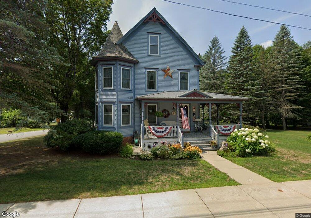
72 Pollard St Conway, NH 03818
Estimated Value: $511,000 - $577,329
5
Beds
4
Baths
2,705
Sq Ft
$203/Sq Ft
Est. Value
About This Home
This home is located at 72 Pollard St, Conway, NH 03818 and is currently estimated at $549,332, approximately $203 per square foot. 72 Pollard St is a home located in Carroll County with nearby schools including A. Crosby Kennett Middle School, Kennett High School, and Robert Frost Charter School.
Ownership History
Date
Name
Owned For
Owner Type
Purchase Details
Closed on
Apr 30, 2001
Sold by
Bloomquist Carroll R and Bloomquist Barbara E
Bought by
Ramunno Margaret Mary
Current Estimated Value
Home Financials for this Owner
Home Financials are based on the most recent Mortgage that was taken out on this home.
Original Mortgage
$139,650
Interest Rate
6.88%
Purchase Details
Closed on
Aug 27, 1999
Sold by
Ramunno Margaret Mary
Bought by
Bloomquist Carroll R and Bloomquist Barbara E
Home Financials for this Owner
Home Financials are based on the most recent Mortgage that was taken out on this home.
Original Mortgage
$157,500
Interest Rate
7.53%
Create a Home Valuation Report for This Property
The Home Valuation Report is an in-depth analysis detailing your home's value as well as a comparison with similar homes in the area
Home Values in the Area
Average Home Value in this Area
Purchase History
| Date | Buyer | Sale Price | Title Company |
|---|---|---|---|
| Ramunno Margaret Mary | $174,600 | -- | |
| Bloomquist Carroll R | $157,500 | -- |
Source: Public Records
Mortgage History
| Date | Status | Borrower | Loan Amount |
|---|---|---|---|
| Open | Bloomquist Carroll R | $115,000 | |
| Closed | Bloomquist Carroll R | $139,650 | |
| Previous Owner | Bloomquist Carroll R | $157,500 |
Source: Public Records
Tax History Compared to Growth
Tax History
| Year | Tax Paid | Tax Assessment Tax Assessment Total Assessment is a certain percentage of the fair market value that is determined by local assessors to be the total taxable value of land and additions on the property. | Land | Improvement |
|---|---|---|---|---|
| 2024 | $6,376 | $496,200 | $50,100 | $446,100 |
| 2023 | $5,915 | $496,200 | $50,100 | $446,100 |
| 2022 | $5,813 | $298,700 | $50,000 | $248,700 |
| 2021 | $4,881 | $298,700 | $50,000 | $248,700 |
| 2020 | $5,484 | $298,700 | $50,000 | $248,700 |
| 2019 | $5,173 | $298,700 | $50,000 | $248,700 |
| 2018 | $5,409 | $248,800 | $50,000 | $198,800 |
| 2017 | $4,971 | $248,800 | $50,000 | $198,800 |
| 2016 | $4,804 | $248,800 | $50,000 | $198,800 |
| 2015 | $4,750 | $248,800 | $50,000 | $198,800 |
| 2014 | $4,692 | $248,800 | $50,000 | $198,800 |
| 2013 | $4,444 | $248,800 | $50,000 | $198,800 |
Source: Public Records
Map
Nearby Homes
- 58 Wilder St
- 20 Washington St
- 6 Main St
- 237 Eaton Rd
- 196 E Main St Unit 5 (old 103)
- 0 W Side Rd Unit 54 5049810
- 9 E Side Rd
- 45 Haynesville Ave Unit 3
- 204 Limac Cir
- 66 Woodland Grove
- lots42,43,44,49 G St
- 18 Woodland Grove Rd
- 369 Tasker Hill Rd
- 592 Eaton Rd
- 115 Swift Valley Rd
- 40 Butternut Ln
- 27 Firelite Rd
- 357 Lamplighters Park
- 15 Trailer Ave
- 66 Lamplighter's Dr