Estimated Value: $299,530 - $334,000
3
Beds
3
Baths
1,792
Sq Ft
$177/Sq Ft
Est. Value
About This Home
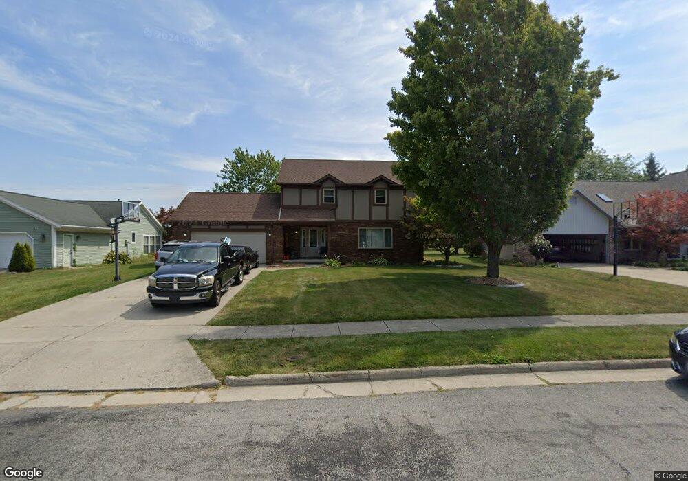
This home is located at 740 Queensbury Dr, Lima, OH 45804 and is currently estimated at $317,383, approximately $177 per square foot. 740 Queensbury Dr is a home located in Allen County with nearby schools including Bath Elementary School, Bath Middle School, and Bath High School.
Ownership History
Date
Name
Owned For
Owner Type
Purchase Details
Closed on
Jan 9, 2006
Sold by
Bogart Phillip S and Bogart Stacey L
Bought by
Cobb Tony T and Cobb Patricia M
Current Estimated Value
Home Financials for this Owner
Home Financials are based on the most recent Mortgage that was taken out on this home.
Original Mortgage
$162,960
Outstanding Balance
$92,407
Interest Rate
6.42%
Mortgage Type
New Conventional
Estimated Equity
$224,976
Purchase Details
Closed on
Apr 11, 2001
Sold by
Goedde Edward A
Bought by
Emrick Gene M and Mulcahy Colleen E
Home Financials for this Owner
Home Financials are based on the most recent Mortgage that was taken out on this home.
Original Mortgage
$112,000
Interest Rate
7.05%
Mortgage Type
New Conventional
Purchase Details
Closed on
Nov 5, 1993
Sold by
Howe Wesley W
Bought by
Goedde Edward A
Purchase Details
Closed on
Mar 5, 1987
Bought by
Howe Wesley W
Create a Home Valuation Report for This Property
The Home Valuation Report is an in-depth analysis detailing your home's value as well as a comparison with similar homes in the area
Purchase History
| Date | Buyer | Sale Price | Title Company |
|---|---|---|---|
| Cobb Tony T | $168,000 | None Available | |
| Emrick Gene M | $158,000 | -- | |
| Goedde Edward A | $138,000 | -- | |
| Howe Wesley W | $14,000 | -- |
Source: Public Records
Mortgage History
| Date | Status | Borrower | Loan Amount |
|---|---|---|---|
| Open | Cobb Tony T | $162,960 | |
| Previous Owner | Emrick Gene M | $112,000 |
Source: Public Records
Tax History
| Year | Tax Paid | Tax Assessment Tax Assessment Total Assessment is a certain percentage of the fair market value that is determined by local assessors to be the total taxable value of land and additions on the property. | Land | Improvement |
|---|---|---|---|---|
| 2024 | $4,295 | $98,880 | $10,290 | $88,590 |
| 2023 | $3,734 | $83,800 | $8,720 | $75,080 |
| 2022 | $3,830 | $85,090 | $8,720 | $76,370 |
| 2021 | $3,852 | $85,090 | $8,720 | $76,370 |
| 2020 | $3,366 | $67,800 | $8,260 | $59,540 |
| 2019 | $3,366 | $67,800 | $8,260 | $59,540 |
| 2018 | $3,103 | $67,800 | $8,260 | $59,540 |
| 2017 | $2,922 | $60,030 | $8,260 | $51,770 |
| 2016 | $3,359 | $69,790 | $8,260 | $61,530 |
| 2015 | $3,362 | $69,790 | $8,260 | $61,530 |
| 2014 | $3,403 | $67,900 | $8,260 | $59,640 |
| 2013 | $3,405 | $67,900 | $8,260 | $59,640 |
Source: Public Records
Map
Nearby Homes
- 819 Canyon Dr
- 120 Barnsbury Dr
- 127 Cheshire Cir
- 108 Valley Way
- 314 Devonshire Dr
- 307 Ridge Crest Cir
- 2525 Harding Hwy
- 712 Radcliffe St
- 1800 Reservoir Rd Unit Lot 51
- 2223 Makin Dr
- 573 Waterview Cir
- 3746 Armstead Place
- 32 Lakeside Dr
- 124 S Collins Ave
- 591 Lakeridge Dr
- 3774 Mount Vernon Place Unit C
- 3833 Harding Hwy
- 304 Pinewood Cir
- 485 S Mumaugh Rd
- 1212 Bellefontaine Ave
Your Personal Tour Guide
Ask me questions while you tour the home.