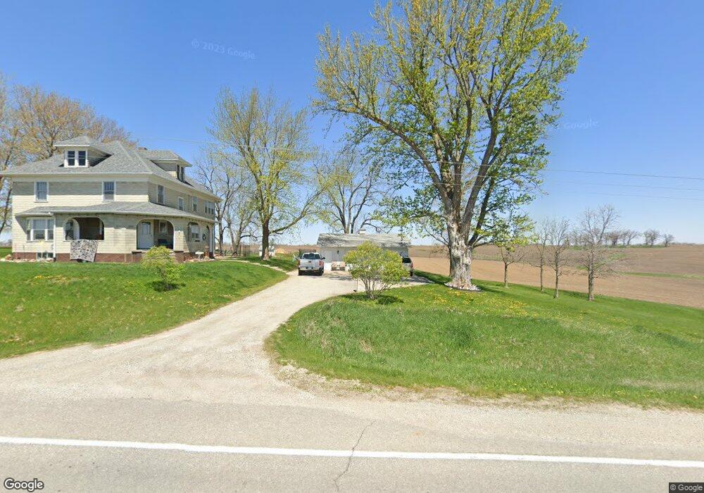
7614 Highway F62 E Reasnor, IA 50232
Estimated Value: $353,971 - $420,000
5
Beds
2
Baths
2,680
Sq Ft
$140/Sq Ft
Est. Value
About This Home
This home is located at 7614 Highway F62 E, Reasnor, IA 50232 and is currently estimated at $376,493, approximately $140 per square foot. 7614 Highway F62 E is a home located in Jasper County with nearby schools including Lynnville-Sully Elementary School, Lynnville-Sully Middle School, and Lynnville-Sully High School.
Ownership History
Date
Name
Owned For
Owner Type
Purchase Details
Closed on
Nov 28, 2007
Sold by
Arends Janet E and Arends Ronald
Bought by
Walker Ryan G and Walker Tammi S
Current Estimated Value
Home Financials for this Owner
Home Financials are based on the most recent Mortgage that was taken out on this home.
Original Mortgage
$146,646
Interest Rate
5.62%
Mortgage Type
Adjustable Rate Mortgage/ARM
Create a Home Valuation Report for This Property
The Home Valuation Report is an in-depth analysis detailing your home's value as well as a comparison with similar homes in the area
Home Values in the Area
Average Home Value in this Area
Purchase History
| Date | Buyer | Sale Price | Title Company |
|---|---|---|---|
| Walker Ryan G | -- | None Available |
Source: Public Records
Mortgage History
| Date | Status | Borrower | Loan Amount |
|---|---|---|---|
| Previous Owner | Walker Ryan G | $146,646 |
Source: Public Records
Tax History Compared to Growth
Tax History
| Year | Tax Paid | Tax Assessment Tax Assessment Total Assessment is a certain percentage of the fair market value that is determined by local assessors to be the total taxable value of land and additions on the property. | Land | Improvement |
|---|---|---|---|---|
| 2025 | $2,808 | $294,010 | $68,400 | $225,610 |
| 2024 | $2,808 | $260,470 | $42,980 | $217,490 |
| 2023 | $2,722 | $260,470 | $42,980 | $217,490 |
| 2022 | $2,362 | $206,020 | $42,980 | $163,040 |
| 2021 | $2,306 | $191,700 | $42,980 | $148,720 |
| 2020 | $2,306 | $177,650 | $41,440 | $136,210 |
| 2019 | $2,140 | $153,280 | $0 | $0 |
| 2018 | $2,140 | $153,280 | $0 | $0 |
| 2017 | $2,174 | $153,280 | $0 | $0 |
| 2016 | $2,174 | $153,280 | $0 | $0 |
| 2015 | $2,148 | $153,280 | $0 | $0 |
| 2014 | $2,072 | $153,280 | $0 | $0 |
Source: Public Records
Map
Nearby Homes
- 7404 Sioux Ave
- 5760 S 80th Ave E
- 6657 E 78th St S
- 5211 S 70th Ave E
- 7233 Highway T 22 S
- 424 Newton St
- 5122 E 84th St S
- 11377 S 100th Ave E
- 11790 Highway F62 E
- 4683 Legion St Unit ST80
- 202 8th Ave
- 205 N 8th Ave
- 805 5th St
- 702 10th Ave
- 1006 2nd St
- 1397 S 52nd Ave E
- 13214 S 112th Ave E
- 297 240th Place
- 413 210th Ave
- 944 Meadow Brook Ave
- 7916 Highway F62 E
- 7803 Highway F62 E
- 7805 Highway F62 E
- 7841 Highway F62 E
- 7390 Highway F62 E
- 7937 Highway F62 E
- 8649 Seneca St
- 8204 Highway F62 E
- 7408 S 84th Ave E
- 8579 Highway F62 E
- 8558 Seneca St
- 8326 Seneca St
- 9401 Highway T14 S
- 9401 Highway T 14 S
- 8129 Highway F62 E
- 8356 Highway F62 E
- 7282 S 84th Ave E
- 8412 Highway F62 E
- 8818 Salmon St
- 9553 Highway T14 S