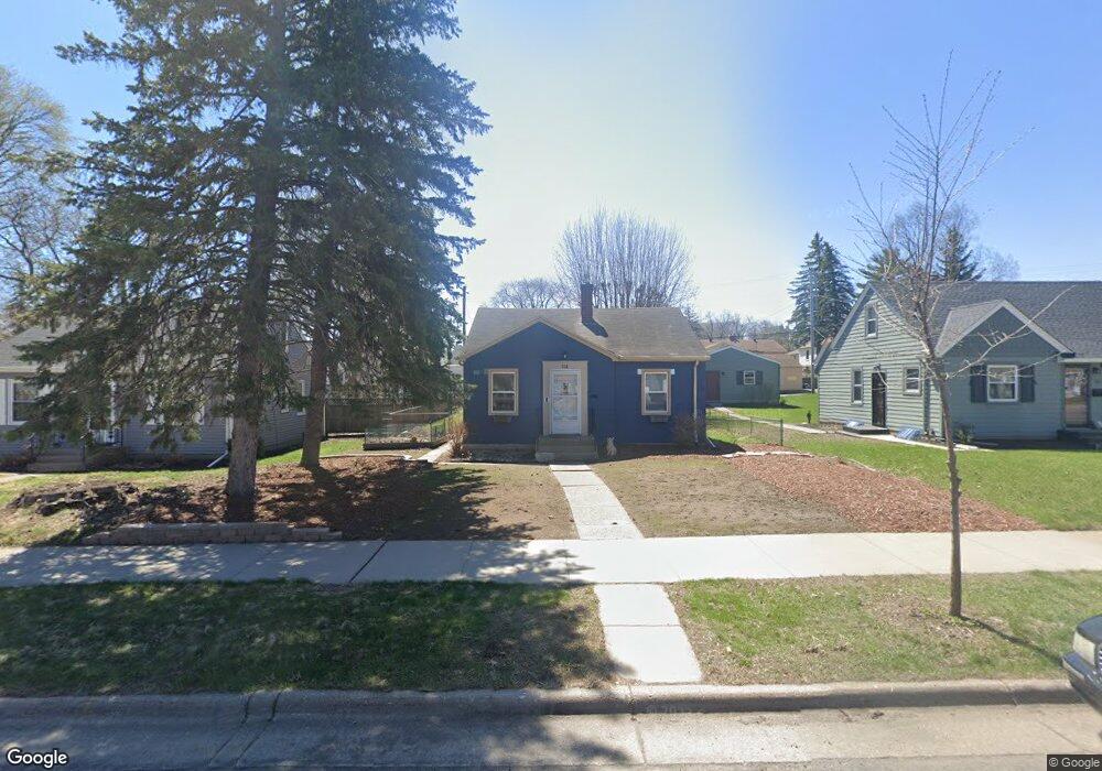
768 Hoyt Ave W Saint Paul, MN 55117
Como Park NeighborhoodEstimated Value: $357,000 - $431,600
4
Beds
2
Baths
2,340
Sq Ft
$167/Sq Ft
Est. Value
About This Home
This home is located at 768 Hoyt Ave W, Saint Paul, MN 55117 and is currently estimated at $389,900, approximately $166 per square foot. 768 Hoyt Ave W is a home located in Ramsey County with nearby schools including Chelsea Heights Elementary, Murray Middle School, and Como Park Senior High School.
Ownership History
Date
Name
Owned For
Owner Type
Purchase Details
Closed on
Apr 5, 2021
Sold by
Walsh Maureen L and Ankney Charles
Bought by
Crashell Nicole and Crashell John
Current Estimated Value
Home Financials for this Owner
Home Financials are based on the most recent Mortgage that was taken out on this home.
Original Mortgage
$240,000
Outstanding Balance
$216,864
Interest Rate
3.05%
Mortgage Type
New Conventional
Estimated Equity
$173,036
Purchase Details
Closed on
Feb 25, 2003
Sold by
Overby John R and Overby Kristen M
Bought by
Biggs Steven C and Biggs Maureen L
Create a Home Valuation Report for This Property
The Home Valuation Report is an in-depth analysis detailing your home's value as well as a comparison with similar homes in the area
Home Values in the Area
Average Home Value in this Area
Purchase History
| Date | Buyer | Sale Price | Title Company |
|---|---|---|---|
| Crashell Nicole | $300,000 | Titlesmart Inc | |
| Biggs Steven C | $194,400 | -- |
Source: Public Records
Mortgage History
| Date | Status | Borrower | Loan Amount |
|---|---|---|---|
| Open | Crashell Nicole | $240,000 |
Source: Public Records
Tax History Compared to Growth
Tax History
| Year | Tax Paid | Tax Assessment Tax Assessment Total Assessment is a certain percentage of the fair market value that is determined by local assessors to be the total taxable value of land and additions on the property. | Land | Improvement |
|---|---|---|---|---|
| 2025 | $5,464 | $425,300 | $60,000 | $365,300 |
| 2023 | $5,464 | $356,400 | $60,000 | $296,400 |
| 2022 | $4,414 | $347,100 | $60,000 | $287,100 |
| 2021 | $4,212 | $281,300 | $60,000 | $221,300 |
| 2020 | $3,882 | $266,900 | $60,000 | $206,900 |
| 2019 | $4,030 | $242,600 | $55,000 | $187,600 |
| 2018 | $3,472 | $237,800 | $55,000 | $182,800 |
| 2017 | $3,458 | $223,300 | $46,400 | $176,900 |
| 2016 | $3,382 | $0 | $0 | $0 |
| 2015 | $3,242 | $199,300 | $46,400 | $152,900 |
| 2014 | $2,816 | $0 | $0 | $0 |
Source: Public Records
Map
Nearby Homes
- 796 Larpenteur Ave W
- 1539 Dale St N
- 1464 Maywood St
- 1342 Dale St N
- 1046 Hoyt Ave W
- 1457 Arundel St
- 1241 Maywood St
- 1600 Arundel St Unit 204
- 1222 Como Blvd E
- 766 Maryland Ave W
- 1005 Como Blvd E
- 408 Arlington Ave W
- tbd MacKubin St
- 373 Nebraska Ave W
- 397 Cottage Ave W Unit 3
- 1801 Western Ave N
- 420 McCarrons Blvd S
- 1165 Norton St
- 1176 Norton St
- 707 Shryer Ave W
- 762 762 Hoyt-Avenue-w
- 762 762 Hoyt Ave W
- 762 Hoyt Ave W
- 780 Hoyt Ave W
- 756 Hoyt Ave W
- 756 756 Hoyt-Avenue-w
- 786 Hoyt Ave W
- 786 786 Hoyt-Avenue-w
- 752 Hoyt Ave W
- 752 752 Hoyt Ave W
- 767 Montana Ave W
- 773 Montana Ave W
- 779 Montana Ave W
- 761 Montana Ave W
- 771 Hoyt Ave W
- 771 771 Hoyt-Avenue-w
- 777 777 Hoyt-Avenue-w
- 777 Hoyt Ave W
- 763 Hoyt Ave W
- 792 Hoyt Ave W