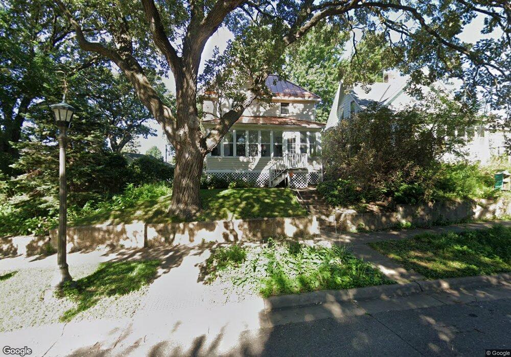
769 Tatum St Saint Paul, MN 55104
Hamline-Midway NeighborhoodEstimated Value: $332,000 - $383,000
3
Beds
2
Baths
1,474
Sq Ft
$237/Sq Ft
Est. Value
About This Home
This home is located at 769 Tatum St, Saint Paul, MN 55104 and is currently estimated at $349,221, approximately $236 per square foot. 769 Tatum St is a home located in Ramsey County with nearby schools including Hancock/Hamline Magnet Elementary School, Murray Middle School, and Como Park Senior High School.
Ownership History
Date
Name
Owned For
Owner Type
Purchase Details
Closed on
Jul 31, 2018
Sold by
Pate Nathaniel
Bought by
Sheehan Cooper James and Michell Cy Elaine
Current Estimated Value
Home Financials for this Owner
Home Financials are based on the most recent Mortgage that was taken out on this home.
Original Mortgage
$201,464
Outstanding Balance
$174,963
Interest Rate
4.5%
Mortgage Type
FHA
Estimated Equity
$174,258
Purchase Details
Closed on
Jan 12, 2018
Sold by
Pate Nathaniel and Heikkita Mary Ann
Bought by
Pate Nathaniel
Purchase Details
Closed on
Jun 22, 2004
Sold by
Lo3 Holdings Llc
Bought by
Nordlund Jason
Create a Home Valuation Report for This Property
The Home Valuation Report is an in-depth analysis detailing your home's value as well as a comparison with similar homes in the area
Home Values in the Area
Average Home Value in this Area
Purchase History
| Date | Buyer | Sale Price | Title Company |
|---|---|---|---|
| Sheehan Cooper James | $240,000 | Premium Title | |
| Pate Nathaniel | -- | None Available | |
| Nordlund Jason | $187,000 | -- |
Source: Public Records
Mortgage History
| Date | Status | Borrower | Loan Amount |
|---|---|---|---|
| Open | Sheehan Cooper James | $201,464 |
Source: Public Records
Tax History Compared to Growth
Tax History
| Year | Tax Paid | Tax Assessment Tax Assessment Total Assessment is a certain percentage of the fair market value that is determined by local assessors to be the total taxable value of land and additions on the property. | Land | Improvement |
|---|---|---|---|---|
| 2025 | $4,926 | $340,000 | $40,000 | $300,000 |
| 2023 | $4,926 | $323,300 | $40,000 | $283,300 |
| 2022 | $3,990 | $296,200 | $40,000 | $256,200 |
| 2021 | $4,192 | $256,700 | $40,000 | $216,700 |
| 2020 | $3,940 | $277,600 | $40,000 | $237,600 |
| 2019 | $3,400 | $245,900 | $35,000 | $210,900 |
| 2018 | $4,328 | $213,200 | $35,000 | $178,200 |
| 2017 | $4,188 | $224,400 | $45,500 | $178,900 |
| 2016 | $4,440 | $0 | $0 | $0 |
| 2015 | $4,308 | $210,900 | $45,500 | $165,400 |
| 2014 | $4,170 | $0 | $0 | $0 |
Source: Public Records
Map
Nearby Homes
- 1831 Englewood Ave
- 682 Fairview Ave N
- 1756 Minnehaha Ave W
- 610 Fairview Ave N
- 1784 Lafond Ave
- 1702 Minnehaha Ave W
- 774 Aldine St
- 1767 Thomas Ave
- 2119 University Ave W
- 1698 Lafond Ave
- 1636 Minnehaha Ave W
- 914 Charlotte St
- 1595 Blair Ave
- 451 Lynnhurst Ave E
- 1897 Feronia Ave
- 1738 University Ave W
- 1665 Sherburne Ave
- 1557 Blair Ave
- 1527 Minnehaha Ave W
- 641 Asbury St
- 773 Tatum St
- 761 Tatum St
- 779 Tatum St
- 1881 Chelton Ave W
- 1895 Chelton Ave W
- 1901 Chelton Ave W
- 781 Tatum St
- 774 Howell St N
- 1905 Chelton Ave W
- 778 Howell St N
- 787 Tatum St
- 784 Howell St N
- 1875 Chelton Ave W
- 1907 Chelton Ave W
- 764 Tatum St
- 1876 Chelton Ave W
- 791 Tatum St
- 760 Tatum St
- 786 Howell St N
- 1872 Chelton Ave W