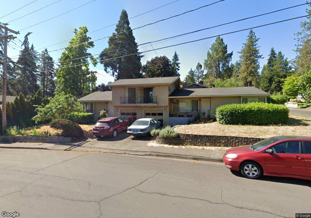
772 Larch St Eugene, OR 97405
Southeast Eugene NeighborhoodEstimated Value: $581,000 - $687,558
5
Beds
4
Baths
2,464
Sq Ft
$251/Sq Ft
Est. Value
About This Home
This home is located at 772 Larch St, Eugene, OR 97405 and is currently estimated at $619,640, approximately $251 per square foot. 772 Larch St is a home located in Lane County with nearby schools including Edgewood Community Elementary School, Spencer Butte Middle School, and South Eugene High School.
Ownership History
Date
Name
Owned For
Owner Type
Purchase Details
Closed on
May 27, 2015
Sold by
Leonard Courtney M
Bought by
Olmstead Daniel H
Current Estimated Value
Home Financials for this Owner
Home Financials are based on the most recent Mortgage that was taken out on this home.
Original Mortgage
$209,900
Interest Rate
3.83%
Mortgage Type
New Conventional
Purchase Details
Closed on
Oct 17, 2003
Sold by
Wright Robert Gary and Wright Shari L
Bought by
Olmstead Daniel H and Leonard Courtney M
Home Financials for this Owner
Home Financials are based on the most recent Mortgage that was taken out on this home.
Original Mortgage
$164,050
Interest Rate
6.4%
Mortgage Type
Purchase Money Mortgage
Create a Home Valuation Report for This Property
The Home Valuation Report is an in-depth analysis detailing your home's value as well as a comparison with similar homes in the area
Home Values in the Area
Average Home Value in this Area
Purchase History
| Date | Buyer | Sale Price | Title Company |
|---|---|---|---|
| Olmstead Daniel H | -- | Cascade Title Company | |
| Olmstead Daniel H | $193,000 | Cascade Title Co |
Source: Public Records
Mortgage History
| Date | Status | Borrower | Loan Amount |
|---|---|---|---|
| Previous Owner | Olmstead Daniel H | $209,900 | |
| Previous Owner | Olmstead Daniel H | $164,050 |
Source: Public Records
Tax History
| Year | Tax Paid | Tax Assessment Tax Assessment Total Assessment is a certain percentage of the fair market value that is determined by local assessors to be the total taxable value of land and additions on the property. | Land | Improvement |
|---|---|---|---|---|
| 2025 | $6,854 | $351,797 | -- | -- |
| 2024 | $6,769 | $341,551 | -- | -- |
| 2023 | $6,769 | $331,603 | $0 | $0 |
| 2022 | $6,341 | $321,945 | $0 | $0 |
| 2021 | $5,956 | $312,568 | $0 | $0 |
| 2020 | $5,977 | $303,465 | $0 | $0 |
| 2019 | $5,773 | $294,627 | $0 | $0 |
| 2018 | $5,434 | $277,715 | $0 | $0 |
| 2017 | $5,191 | $277,715 | $0 | $0 |
| 2016 | $4,924 | $269,626 | $0 | $0 |
| 2015 | $4,661 | $261,773 | $0 | $0 |
| 2014 | -- | $254,149 | $0 | $0 |
Source: Public Records
Map
Nearby Homes
- 4680 W Hillside Dr
- 4429 Fox Hollow Rd Unit 3
- 4425 Hilyard St
- 4364 Fox Hollow Rd
- 892 Sprague St
- 4733 E Amazon Dr
- 910 E 43rd Ave
- 4320 Fox Hollow Rd
- 4845 Brookwood St
- 4295 Ferry St
- 4734 Brookwood St
- 395 E 46th Ave
- 4835 Elva Ln
- 4023 Donald St Unit K
- 1660 Leatherwood Dr
- 1755 E 43rd Ave
- 0 E 39th Ave
- 434 E 39th Ave
- 0 N Shasta Loop Unit 384285834
- 3817 E Amazon Dr
- 4535 Manzanita St
- 790 Larch St
- 4545 Manzanita St
- 781 Larch St
- 4510 Manzanita St
- 4540 Manzanita St
- 765 Larch St
- 770 Larch St
- 4565 Manzanita St
- 4630 W Hillside Dr
- 791 Larch St
- 796 Larch St
- 765 Mimosa Ave
- 755 Larch St
- 797 Larch St
- 4650 W Hillside Dr
- 4485 Larkwood St
- 4575 Manzanita St
- 4515 Larkwood St
- 4545 Larkwood St
Your Personal Tour Guide
Ask me questions while you tour the home.