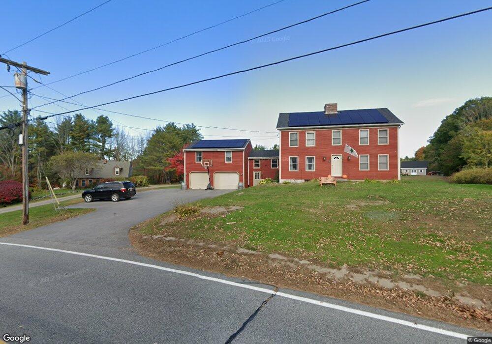
79 Watson Mill Rd Saco, ME 04072
North Saco NeighborhoodEstimated Value: $465,000 - $765,000
4
Beds
3
Baths
2,986
Sq Ft
$215/Sq Ft
Est. Value
About This Home
This home is located at 79 Watson Mill Rd, Saco, ME 04072 and is currently estimated at $642,995, approximately $215 per square foot. 79 Watson Mill Rd is a home located in York County with nearby schools including C K Burns School and Saco Middle School.
Ownership History
Date
Name
Owned For
Owner Type
Purchase Details
Closed on
Dec 22, 2009
Sold by
Bedell Stephen G and Bedell Sussanna E
Bought by
Sastre Conrado T and Sastre Sheri L
Current Estimated Value
Home Financials for this Owner
Home Financials are based on the most recent Mortgage that was taken out on this home.
Original Mortgage
$223,850
Outstanding Balance
$151,140
Interest Rate
5%
Mortgage Type
FHA
Estimated Equity
$491,855
Create a Home Valuation Report for This Property
The Home Valuation Report is an in-depth analysis detailing your home's value as well as a comparison with similar homes in the area
Home Values in the Area
Average Home Value in this Area
Purchase History
| Date | Buyer | Sale Price | Title Company |
|---|---|---|---|
| Sastre Conrado T | -- | -- |
Source: Public Records
Mortgage History
| Date | Status | Borrower | Loan Amount |
|---|---|---|---|
| Open | Sastre Conrado T | $223,850 | |
| Previous Owner | Sastre Conrado T | $77,250 | |
| Previous Owner | Sastre Conrado T | $116,000 |
Source: Public Records
Tax History
| Year | Tax Paid | Tax Assessment Tax Assessment Total Assessment is a certain percentage of the fair market value that is determined by local assessors to be the total taxable value of land and additions on the property. | Land | Improvement |
|---|---|---|---|---|
| 2024 | $6,106 | $434,600 | $151,900 | $282,700 |
| 2023 | $6,410 | $434,600 | $151,900 | $282,700 |
| 2022 | $5,739 | $313,100 | $115,700 | $197,400 |
| 2021 | $5,426 | $287,400 | $104,400 | $183,000 |
| 2020 | $5,138 | $261,200 | $91,800 | $169,400 |
| 2019 | $5,062 | $261,200 | $91,800 | $169,400 |
| 2018 | $4,952 | $252,900 | $83,500 | $169,400 |
| 2017 | $4,421 | $248,100 | $76,500 | $171,600 |
| 2016 | $5,243 | $270,000 | $61,500 | $208,500 |
| 2015 | $5,116 | $266,200 | $60,200 | $206,000 |
| 2014 | $4,957 | $266,200 | $60,200 | $206,000 |
| 2013 | $4,946 | $266,200 | $60,200 | $206,000 |
Source: Public Records
Map
Nearby Homes
- Lot 1 & 2 Memory Ln
- 181 Watson Mill Rd
- 3 Trapper John Rd
- 130 Heath Rd
- 5 Moose Creek Ln
- 153 Mckenney Rd
- 4 Lebanon Rd
- 91 C Broadturn Rd
- 8 Peaceful Ln
- 75 Ash Swamp Rd
- 3 Dunn Estates Dr
- Lot 72 Martell Way
- 1 Shamrock Dr
- 00 Miso Way
- 213 Burnham Rd
- 12 Maple Dr
- 0 Simpson Rd
- 6 Leah Ln
- 64 Maple Dr
- 4 Primrose Ln
- 78 Watson Mill Rd
- 73 Watson Mill Rd
- 72 Watson Mill Rd
- 70 Watson Mill Rd
- 86 Watson Mill Rd
- 93 Watson Mill Rd
- 68 Watson Mill Rd
- 4 Nonesuch Rd
- 69 Watson Mill Rd
- 62 Watson Mill Rd
- 7 Nonesuch Rd
- 87 Watson Mill Rd
- 54 Mast Hill Rd
- 61 Watson Mill Rd
- 56 Watson Mill Rd
- 5 Grace Ln
- 112 Watson Mill Rd
- 184 Watson Mill Rd
- 89 Watson Mill Rd
- Lot A Watson Mill Rd
Your Personal Tour Guide
Ask me questions while you tour the home.