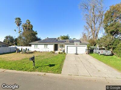
7933 Moreland St Stockton, CA 95212
Estimated Value: $483,000 - $500,000
3
Beds
2
Baths
1,523
Sq Ft
$323/Sq Ft
Est. Value
About This Home
This home is located at 7933 Moreland St, Stockton, CA 95212 and is currently estimated at $492,526, approximately $323 per square foot. 7933 Moreland St is a home located in San Joaquin County with nearby schools including Ansel Adams School, Morada Middle School, and Ronald E. McNair High School.
Ownership History
Date
Name
Owned For
Owner Type
Purchase Details
Closed on
Oct 1, 2009
Sold by
Segura John M
Bought by
Nino David C and Nino Maria O
Current Estimated Value
Home Financials for this Owner
Home Financials are based on the most recent Mortgage that was taken out on this home.
Original Mortgage
$116,800
Interest Rate
5.05%
Mortgage Type
Purchase Money Mortgage
Purchase Details
Closed on
Jun 16, 2005
Sold by
Va
Bought by
Segura John M
Create a Home Valuation Report for This Property
The Home Valuation Report is an in-depth analysis detailing your home's value as well as a comparison with similar homes in the area
Home Values in the Area
Average Home Value in this Area
Purchase History
| Date | Buyer | Sale Price | Title Company |
|---|---|---|---|
| Nino David C | $165,000 | Placer Title Company | |
| Segura John M | -- | -- |
Source: Public Records
Mortgage History
| Date | Status | Borrower | Loan Amount |
|---|---|---|---|
| Open | Nino David C | $125,000 | |
| Closed | Nino David C | $116,800 |
Source: Public Records
Tax History Compared to Growth
Tax History
| Year | Tax Paid | Tax Assessment Tax Assessment Total Assessment is a certain percentage of the fair market value that is determined by local assessors to be the total taxable value of land and additions on the property. | Land | Improvement |
|---|---|---|---|---|
| 2024 | $3,667 | $217,652 | $51,880 | $165,772 |
| 2023 | $3,543 | $213,385 | $50,863 | $162,522 |
| 2022 | $3,335 | $209,202 | $49,866 | $159,336 |
| 2021 | $3,354 | $205,101 | $48,889 | $156,212 |
| 2020 | $3,281 | $202,999 | $48,388 | $154,611 |
| 2019 | $3,200 | $199,020 | $47,440 | $151,580 |
| 2018 | $2,983 | $195,118 | $46,510 | $148,608 |
| 2017 | $2,898 | $191,294 | $45,599 | $145,695 |
| 2016 | $2,756 | $187,546 | $44,706 | $142,840 |
| 2014 | $2,688 | $181,113 | $43,172 | $137,941 |
Source: Public Records
Map
Nearby Homes
- 8271 Shay Cir
- 3648 Mykala Dr
- 8169 Shay Cir
- 8061 Shay Cir
- 4855 Foppiano Ln
- 5100 N Highway 99 Unit 194
- 5100 N Highway 99 Unit 202
- 5100 N Highway 99 Unit 182
- 5100 N Highway 99 Unit 90
- 5100 N Highway 99 Unit 31
- 5100 N Highway 99 Unit 83
- 8607 Treasure Ave
- 8555 Arbour Rd
- 9042 Chianti Cir
- 3347 McVie Dr
- 5031 Cozad Way
- 8352 Meath Dr
- 3345 Tenaya Ln
- 8621 Leadon Dr
- 8360 Lucienne Dr
- 7933 Moreland St
- 7947 Moreland St
- 7849 Moreland St
- 7961 Moreland St
- 7830 Omega Way
- 7844 Omega Way
- 7892 Moreland St
- 4225 E Hammer Ln
- 7862 Moreland St
- 7985 Moreland St
- 7954 Moreland St
- 7902 Omega Way
- 4144 Mercy Ln
- 7914 Omega Way
- 7980 Moreland St
- 8045 Moreland St
- 4169 E Hammer Ln
- 4130 Mercy Ln
- 7928 Omega Way
- 4143 Mercy Ln