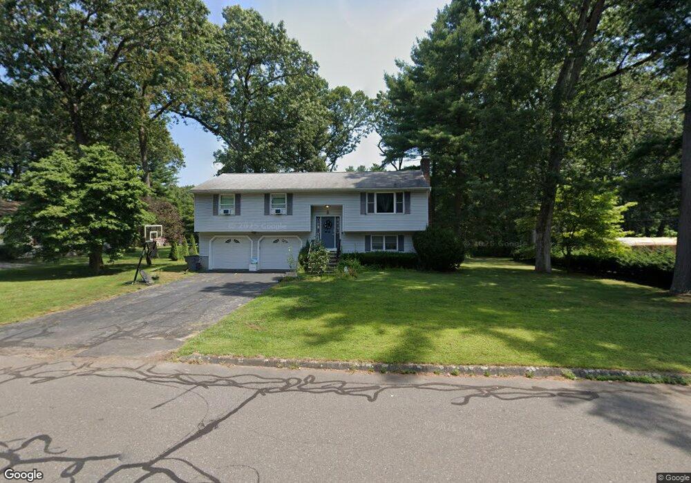
8 E Forrest Dr Enfield, CT 06082
Estimated Value: $340,000 - $371,000
3
Beds
2
Baths
1,588
Sq Ft
$223/Sq Ft
Est. Value
About This Home
This home is located at 8 E Forrest Dr, Enfield, CT 06082 and is currently estimated at $353,923, approximately $222 per square foot. 8 E Forrest Dr is a home located in Hartford County with nearby schools including Prudence Crandall Elementary School, Henry Barnard Elementary School, and Enfield High School.
Ownership History
Date
Name
Owned For
Owner Type
Purchase Details
Closed on
Apr 11, 2023
Sold by
Hafey Jennette K and Hafey James W
Bought by
Breton Tyler S and Hoffman Patricia
Current Estimated Value
Home Financials for this Owner
Home Financials are based on the most recent Mortgage that was taken out on this home.
Original Mortgage
$259,000
Outstanding Balance
$251,802
Interest Rate
6.6%
Mortgage Type
Stand Alone Refi Refinance Of Original Loan
Estimated Equity
$102,121
Purchase Details
Closed on
Aug 23, 1991
Sold by
Moskwa John and Moskwa Kristina
Bought by
Hafey James and Hafey Jeanette
Create a Home Valuation Report for This Property
The Home Valuation Report is an in-depth analysis detailing your home's value as well as a comparison with similar homes in the area
Home Values in the Area
Average Home Value in this Area
Purchase History
| Date | Buyer | Sale Price | Title Company |
|---|---|---|---|
| Breton Tyler S | $300,000 | None Available | |
| Breton Tyler S | $300,000 | None Available | |
| Hafey James | $145,900 | -- |
Source: Public Records
Mortgage History
| Date | Status | Borrower | Loan Amount |
|---|---|---|---|
| Open | Breton Tyler S | $259,000 | |
| Closed | Breton Tyler S | $259,000 | |
| Previous Owner | Hafey James | $30,000 | |
| Previous Owner | Hafey James | $77,831 | |
| Previous Owner | Hafey James | $97,000 | |
| Previous Owner | Hafey James | $109,425 |
Source: Public Records
Tax History
| Year | Tax Paid | Tax Assessment Tax Assessment Total Assessment is a certain percentage of the fair market value that is determined by local assessors to be the total taxable value of land and additions on the property. | Land | Improvement |
|---|---|---|---|---|
| 2025 | $6,265 | $180,800 | $55,000 | $125,800 |
| 2024 | $6,113 | $180,800 | $55,000 | $125,800 |
| 2023 | $6,013 | $180,800 | $55,000 | $125,800 |
| 2022 | $55 | $180,800 | $55,000 | $125,800 |
| 2021 | $5,315 | $142,180 | $45,420 | $96,760 |
| 2020 | $5,315 | $142,180 | $45,420 | $96,760 |
| 2019 | $5,315 | $142,180 | $45,420 | $96,760 |
| 2018 | $5,197 | $142,180 | $45,420 | $96,760 |
| 2017 | $4,917 | $142,180 | $45,420 | $96,760 |
| 2016 | $5,019 | $147,570 | $45,420 | $102,150 |
| 2015 | $4,876 | $147,570 | $45,420 | $102,150 |
| 2014 | $4,764 | $147,570 | $45,420 | $102,150 |
Source: Public Records
Map
Nearby Homes
- 14 W Forrest Dr
- 39 Liberty Ln
- 54 Liberty Ln
- 56 Liberty Ln
- 46 Liberty Ln
- 43 Liberty Ln
- 41 Liberty Ln
- 59 Liberty Ln
- 44 Liberty Ln
- 60 Liberty Ln
- 42 Liberty Ln
- 50 Liberty Ln
- 449 The Meadows
- 15 Pine Hill Rd
- 176 Cottage Rd
- 137 the Laurels Unit 137
- 208 Birch Rd
- 50 Roosevelt Blvd
- 357 Maple Rd
- 53 Meadowlark Dr
Your Personal Tour Guide
Ask me questions while you tour the home.