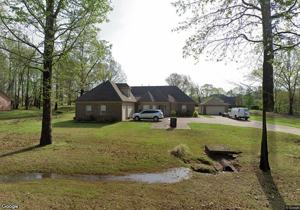
8006 Camptown Ln Olive Branch, MS 38654
Estimated Value: $391,018 - $430,000
4
Beds
--
Bath
3,032
Sq Ft
$133/Sq Ft
Est. Value
About This Home
This home is located at 8006 Camptown Ln, Olive Branch, MS 38654 and is currently estimated at $403,505, approximately $133 per square foot. 8006 Camptown Ln is a home located in DeSoto County with nearby schools including Olive Branch Elementary School, Chickasaw Elementary School, and Olive Branch Middle School.
Ownership History
Date
Name
Owned For
Owner Type
Purchase Details
Closed on
Oct 4, 2010
Sold by
Deutsche Bank National Trust Company
Bought by
Wilson Wendy
Current Estimated Value
Purchase Details
Closed on
Jul 8, 2008
Sold by
Burt Jeffery
Bought by
Deutsche Bank National Trust Company
Purchase Details
Closed on
Apr 7, 2008
Sold by
Burt Jeffrey Lenard
Bought by
Green Terry W
Purchase Details
Closed on
Mar 29, 2005
Sold by
Investco Belz
Bought by
Burt Jeffrey
Create a Home Valuation Report for This Property
The Home Valuation Report is an in-depth analysis detailing your home's value as well as a comparison with similar homes in the area
Home Values in the Area
Average Home Value in this Area
Purchase History
| Date | Buyer | Sale Price | Title Company |
|---|---|---|---|
| Wilson Wendy | -- | Landcastle Title Llc | |
| Deutsche Bank National Trust Company | $229,500 | None Available | |
| Green Terry W | $1,500 | None Available | |
| Burt Jeffrey | -- | None Available |
Source: Public Records
Tax History
| Year | Tax Paid | Tax Assessment Tax Assessment Total Assessment is a certain percentage of the fair market value that is determined by local assessors to be the total taxable value of land and additions on the property. | Land | Improvement |
|---|---|---|---|---|
| 2025 | $3,538 | $30,559 | $4,000 | $26,559 |
| 2024 | $3,050 | $22,349 | $4,000 | $18,349 |
| 2023 | $3,050 | $22,349 | $0 | $0 |
| 2022 | $2,750 | $22,349 | $4,000 | $18,349 |
| 2021 | $2,750 | $22,349 | $4,000 | $18,349 |
| 2020 | $2,850 | $20,881 | $4,000 | $16,881 |
| 2019 | $819 | $6,000 | $6,000 | $0 |
| 2017 | $823 | $6,000 | $6,000 | $0 |
| 2016 | $2,938 | $6,000 | $6,000 | $0 |
| 2015 | $823 | $6,000 | $6,000 | $0 |
| 2014 | $823 | $6,000 | $0 | $0 |
| 2013 | $799 | $6,000 | $0 | $0 |
Source: Public Records
Map
Nearby Homes
- 7738 Windersgate Cir
- 8321 Windersgate Dr
- 8040 Hunt Club Cove
- 7961 Allendale Cove
- 7922 Allendale Cove
- 8798 Hunters Horn Cove
- 7885 Hunters Bend Cove
- 8390 Ms-178
- 8699 Courtly Cir N
- 7831 Ferndale Dr
- 8870 Collinswood Dr
- 7899 Gardendale Dr
- 7435 Murry Hill Cir
- 7736 Ferndale Dr
- 7881 Gardendale Dr
- 7721 Ferndale Dr
- 7867 Gardendale Dr
- 7745 Ferndale Dr
- 7851 Gardendale Dr
- 7935 Hickory Cove
- 8020 Camptown Ln
- 7992 Camptown Ln
- 7957 Windersgate Cir
- 7999 Windersgate Cir
- 8003 Camptown Ln
- 7989 Camptown Ln
- 7929 Windersgate Cir
- 8017 Camptown Ln
- 7978 Camptown Ln
- 8327 Kings Crossing Dr
- 8000 Windersgate Cir
- 8041 Windersgate Cir
- 7996 Glenn View Cove
- 8031 Camptown Ln
- 7887 Windersgate Cir
- 7972 Windersgate Cir
- 7964 Camptown Ln
- 7944 Windersgate Cir
- 8406 Westbrook Dr
- 16 Westbrook Dr
Your Personal Tour Guide
Ask me questions while you tour the home.