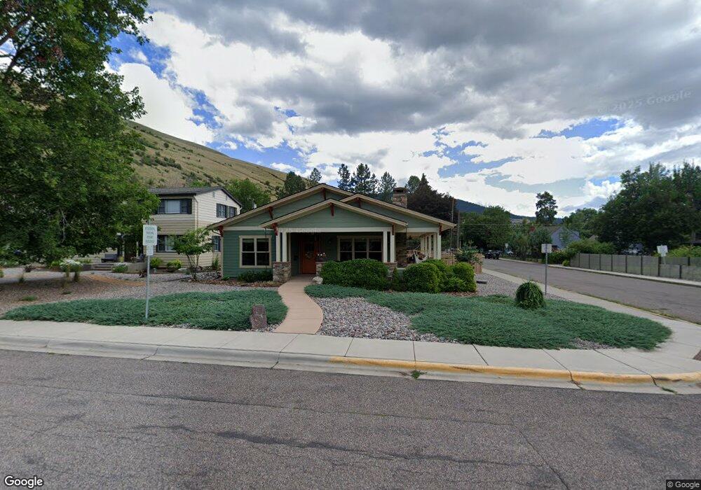
803 Beverly Ave Missoula, MT 59801
University District NeighborhoodEstimated Value: $790,000 - $903,638
3
Beds
3
Baths
1,736
Sq Ft
$490/Sq Ft
Est. Value
About This Home
This home is located at 803 Beverly Ave, Missoula, MT 59801 and is currently estimated at $850,910, approximately $490 per square foot. 803 Beverly Ave is a home with nearby schools including Paxson School, Washington Middle School, and Hellgate High School.
Ownership History
Date
Name
Owned For
Owner Type
Purchase Details
Closed on
Jan 8, 2016
Sold by
Caron Richard A and Reede Caron Darcy
Bought by
Schmitz Nancy J and Schmitz Eugene D
Current Estimated Value
Home Financials for this Owner
Home Financials are based on the most recent Mortgage that was taken out on this home.
Original Mortgage
$154,400
Outstanding Balance
$125,871
Interest Rate
4.75%
Mortgage Type
Adjustable Rate Mortgage/ARM
Estimated Equity
$725,039
Purchase Details
Closed on
Jul 17, 2008
Sold by
Tripp Eugene and Tripp Colleen D
Bought by
Caron Richard A and Reede Caron Darcy
Create a Home Valuation Report for This Property
The Home Valuation Report is an in-depth analysis detailing your home's value as well as a comparison with similar homes in the area
Home Values in the Area
Average Home Value in this Area
Purchase History
| Date | Buyer | Sale Price | Title Company |
|---|---|---|---|
| Schmitz Nancy J | -- | Title Services Inc | |
| Caron Richard A | -- | Title Services Inc |
Source: Public Records
Mortgage History
| Date | Status | Borrower | Loan Amount |
|---|---|---|---|
| Open | Schmitz Nancy J | $154,400 |
Source: Public Records
Tax History Compared to Growth
Tax History
| Year | Tax Paid | Tax Assessment Tax Assessment Total Assessment is a certain percentage of the fair market value that is determined by local assessors to be the total taxable value of land and additions on the property. | Land | Improvement |
|---|---|---|---|---|
| 2025 | $9,094 | $840,380 | $349,830 | $490,550 |
| 2024 | $8,840 | $717,000 | $279,240 | $437,760 |
| 2023 | $8,517 | $726,400 | $279,240 | $447,160 |
| 2022 | $7,480 | $553,400 | $0 | $0 |
| 2021 | $6,723 | $553,400 | $0 | $0 |
| 2020 | $6,966 | $532,600 | $0 | $0 |
| 2019 | $6,943 | $532,600 | $0 | $0 |
| 2018 | $6,763 | $504,400 | $0 | $0 |
| 2017 | $5,214 | $395,370 | $0 | $0 |
| 2016 | $2,033 | $161,460 | $0 | $0 |
| 2015 | $1,881 | $161,460 | $0 | $0 |
| 2014 | $1,639 | $79,290 | $0 | $0 |
Source: Public Records
Map
Nearby Homes
- 831 Hastings Ave
- 839 Evans Ave
- 1700 Arthur Ave
- 546 Woodworth Ave
- 921 E Beckwith Ave
- 401 Woodworth Ave
- 340 Evans Ave
- 322 Evans Ave
- 1617 Ronald Ave
- 109 E Central Ave
- 1325 Gerald Ave
- 101 E Central Ave
- 116 South Ave E
- Lot 26a South Ave W
- 542 Eddy Ave
- 540 Ford St
- 300 Connell Ave
- 951 Ronald Ave Unit 304
- 225 Eddy Ave
- 516 S 5th St E
- 809 Beverly Ave
- 815 Beverly Ave
- 800 Woodworth Ave
- 810 Woodworth Ave
- 1839 Mansfield Ave
- 1839 Mansfield Ave
- 725 Beverly Ave
- 800 Beverly Ave
- 820 Woodworth Ave
- 808 Beverly Ave
- 810 Beverly Ave
- 730 Woodworth Ave
- 855 Beverly Ave
- 1737 Mansfield Ave
- 824 Beverly Ave
- 856 Woodworth Ave
- 715 Beverly Ave
- 724 Beverly Ave
- 724 Beverly Ave
- 720 Woodworth Ave