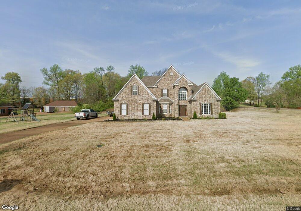
8051 Camptown Ln Olive Branch, MS 38654
Estimated Value: $392,000 - $421,000
4
Beds
--
Bath
2,901
Sq Ft
$140/Sq Ft
Est. Value
About This Home
This home is located at 8051 Camptown Ln, Olive Branch, MS 38654 and is currently estimated at $404,954, approximately $139 per square foot. 8051 Camptown Ln is a home located in DeSoto County with nearby schools including Olive Branch Elementary School, Chickasaw Elementary School, and Olive Branch Middle School.
Ownership History
Date
Name
Owned For
Owner Type
Purchase Details
Closed on
Nov 23, 2020
Sold by
Miller Henry and Miller Sandra
Bought by
Valentine Dewayne Cortez
Current Estimated Value
Home Financials for this Owner
Home Financials are based on the most recent Mortgage that was taken out on this home.
Original Mortgage
$246,000
Outstanding Balance
$177,688
Interest Rate
2.8%
Mortgage Type
New Conventional
Estimated Equity
$227,266
Create a Home Valuation Report for This Property
The Home Valuation Report is an in-depth analysis detailing your home's value as well as a comparison with similar homes in the area
Home Values in the Area
Average Home Value in this Area
Purchase History
| Date | Buyer | Sale Price | Title Company |
|---|---|---|---|
| Valentine Dewayne Cortez | -- | Regency Title And Escrow Llc |
Source: Public Records
Mortgage History
| Date | Status | Borrower | Loan Amount |
|---|---|---|---|
| Open | Valentine Dewayne Cortez | $246,000 | |
| Closed | Valentine Dewayne Cortez | $289,656 |
Source: Public Records
Tax History Compared to Growth
Tax History
| Year | Tax Paid | Tax Assessment Tax Assessment Total Assessment is a certain percentage of the fair market value that is determined by local assessors to be the total taxable value of land and additions on the property. | Land | Improvement |
|---|---|---|---|---|
| 2024 | $3,010 | $22,056 | $4,000 | $18,056 |
| 2023 | $3,010 | $22,056 | $0 | $0 |
| 2022 | $3,010 | $22,056 | $4,000 | $18,056 |
| 2021 | $3,010 | $22,056 | $4,000 | $18,056 |
| 2020 | $2,510 | $20,592 | $4,000 | $16,592 |
| 2019 | $2,510 | $20,592 | $4,000 | $16,592 |
| 2017 | $2,464 | $36,292 | $20,146 | $16,146 |
| 2016 | $2,464 | $20,146 | $4,000 | $16,146 |
| 2015 | $2,764 | $36,292 | $20,146 | $16,146 |
| 2014 | $2,587 | $21,043 | $0 | $0 |
| 2013 | $2,574 | $21,043 | $0 | $0 |
Source: Public Records
Map
Nearby Homes
- 8017 Camptown Ln
- 8390 Ms-178
- 1930 Plan at Allendale
- 7888 Allenwood Ln
- 7880 Allenwood Ln
- 7843 Ferndale Dr
- 7826 Ferndale Dr
- 7885 Hunters Bend Cove
- 7759 Ferndale Dr
- 7975 Crescent Cir
- 7905 Gardendale Dr
- 7736 Ferndale Dr
- 7721 Ferndale Dr
- 7899 Gardendale Dr
- 7881 Gardendale Dr
- 7875 Gardendale Dr
- 7867 Gardendale Dr
- 7859 Gardendale Dr
- 7384 Woodland Dr
- 8870 Collinswood Dr
- 8051 Camptown Cove
- 8065 Camptown Ln
- 16 Westbrook Dr
- 8323 Westbrook Dr
- 8031 Camptown Ln
- 8341 Westbrook Dr
- 8068 Camptown Ln
- 8074 Camptown Ln
- 8074 Camptown Cove
- 8316 Westbrook Dr
- 8317 Westbrook Dr
- 8345 Westbrook Dr
- 8302 Westbrook Dr
- 8041 Windersgate Cir
- 8303 Westbrook Dr
- 8302 Westbrook Dr
- 8053 Windersgate Cir
- 8083 Windersgate Cir
- 8171 Springbrook Cove
- 8003 Camptown Ln