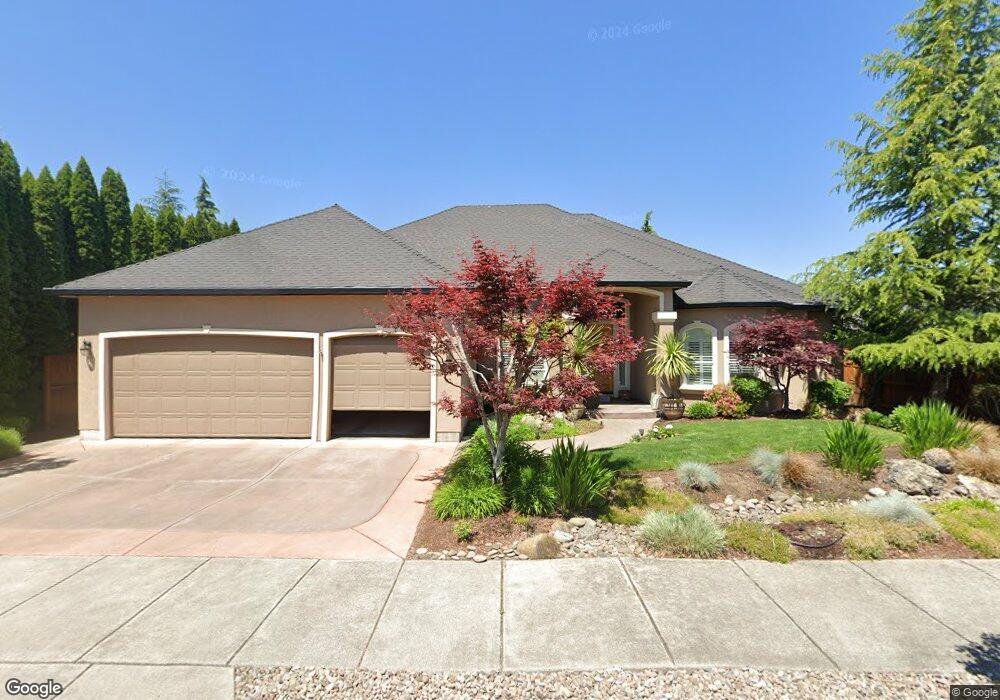
810 St Andrews Way Eagle Point, OR 97524
Estimated Value: $669,292 - $733,000
3
Beds
3
Baths
3,061
Sq Ft
$231/Sq Ft
Est. Value
About This Home
This home is located at 810 St Andrews Way, Eagle Point, OR 97524 and is currently estimated at $707,573, approximately $231 per square foot. 810 St Andrews Way is a home located in Jackson County with nearby schools including Eagle Point Middle School, White Mountain Middle School, and Eagle Point High School.
Ownership History
Date
Name
Owned For
Owner Type
Purchase Details
Closed on
Mar 7, 2003
Sold by
Eagle Point Developments Llc
Bought by
Townsend Larry D and Townsend Karen H
Current Estimated Value
Home Financials for this Owner
Home Financials are based on the most recent Mortgage that was taken out on this home.
Original Mortgage
$262,900
Outstanding Balance
$108,252
Interest Rate
5.79%
Mortgage Type
Construction
Estimated Equity
$599,321
Create a Home Valuation Report for This Property
The Home Valuation Report is an in-depth analysis detailing your home's value as well as a comparison with similar homes in the area
Home Values in the Area
Average Home Value in this Area
Purchase History
| Date | Buyer | Sale Price | Title Company |
|---|---|---|---|
| Townsend Larry D | $78,900 | Lawyers Title Insurance Corp |
Source: Public Records
Mortgage History
| Date | Status | Borrower | Loan Amount |
|---|---|---|---|
| Open | Townsend Larry D | $262,900 |
Source: Public Records
Tax History
| Year | Tax Paid | Tax Assessment Tax Assessment Total Assessment is a certain percentage of the fair market value that is determined by local assessors to be the total taxable value of land and additions on the property. | Land | Improvement |
|---|---|---|---|---|
| 2026 | $6,329 | $448,370 | $128,000 | $320,370 |
| 2025 | $6,179 | $451,600 | $72,190 | $379,410 |
| 2024 | $6,179 | $438,450 | $70,080 | $368,370 |
| 2023 | $5,970 | $425,680 | $68,040 | $357,640 |
| 2022 | $5,807 | $425,680 | $68,040 | $357,640 |
| 2021 | $5,635 | $413,290 | $66,060 | $347,230 |
| 2020 | $5,986 | $401,260 | $64,140 | $337,120 |
| 2019 | $5,895 | $378,240 | $60,460 | $317,780 |
| 2018 | $5,783 | $367,230 | $58,700 | $308,530 |
| 2017 | $5,641 | $367,230 | $58,700 | $308,530 |
| 2016 | $5,531 | $346,160 | $55,330 | $290,830 |
| 2015 | $5,350 | $346,160 | $55,330 | $290,830 |
| 2014 | $5,197 | $326,300 | $52,160 | $274,140 |
Source: Public Records
Map
Nearby Homes
- 888 Arrowhead Trail
- 936 Arrowhead Trail
- 964 Pumpkin Ridge
- 162 Bellerive Dr
- 995 Pumpkin Ridge
- 210 Bellerive Dr
- 32 Pebble Creek Dr
- 621 S Shasta Ave
- 407 S Shasta Ave
- 421 Stevens Rd Unit 20
- 421 Stevens Rd Unit 14
- 421 Stevens Rd Unit 52
- 1043 Arrowhead Trail
- 74 Eagle View Dr
- 131 Spanish Bay Ct
- 202 Bogey Ln
- 160 Keystone Way
- 620 S Royal Ave
- 374 Leandra Ln
- 1134 Pumpkin Ridge Unit 337
- 118 Bellerive Dr
- 816 St Andrews Way Unit L142
- 816 St Andrews Way
- 112 Bellerive Dr
- 820 St Andrews Way
- 821 St Andrews Way
- 815 St Andrews Way
- 894 Arrowhead Trail
- 824 St Andrews Way
- 827 Saint Andrews Way
- 827 St Andrews Way
- 124 Bellerive Dr
- 882 Arrowhead Trail
- 828 St Andrews Way
- 828 St Andrews Lot 139 Way
- 113 Bellerive Lot #146 Dr
- 41 Aspen Ct
- 113 Bellerive Dr
- 107 Bellerive Dr
- 833 St Andrews Way
Your Personal Tour Guide
Ask me questions while you tour the home.