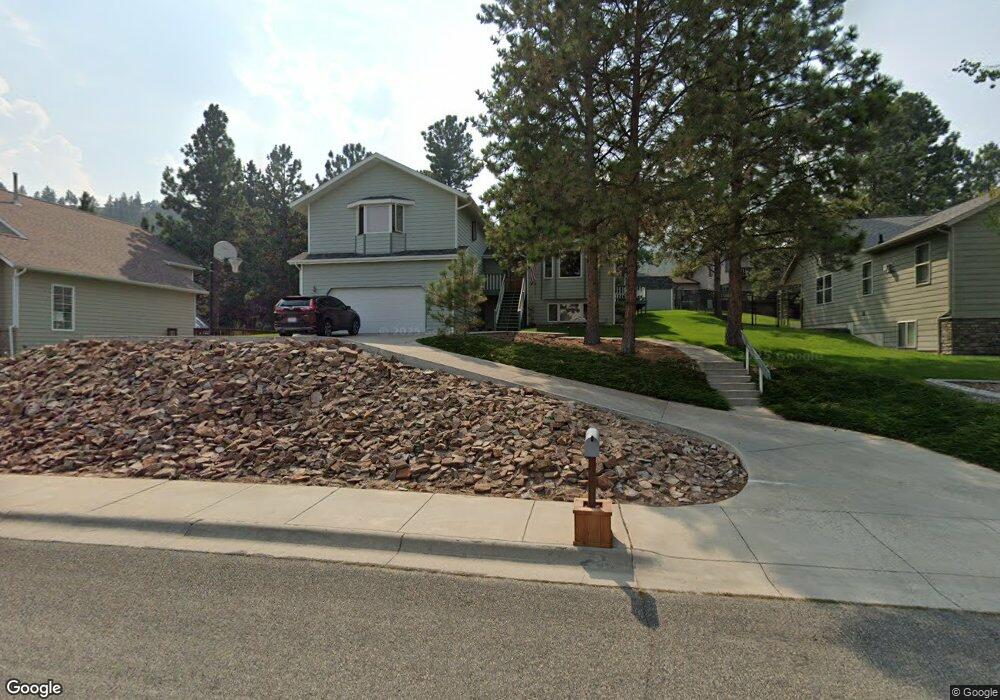
831 Lode St Helena, MT 59601
Upper East Side NeighborhoodEstimated Value: $616,352 - $669,000
4
Beds
4
Baths
2,202
Sq Ft
$290/Sq Ft
Est. Value
About This Home
This home is located at 831 Lode St, Helena, MT 59601 and is currently estimated at $638,088, approximately $289 per square foot. 831 Lode St is a home located in Lewis and Clark County with nearby schools including Smith School, Helena Middle School, and Helena Adventist Christian School.
Ownership History
Date
Name
Owned For
Owner Type
Purchase Details
Closed on
Aug 2, 2021
Sold by
Franks Patricia A and Franks Eugene C
Bought by
Petersen Helen L
Current Estimated Value
Home Financials for this Owner
Home Financials are based on the most recent Mortgage that was taken out on this home.
Original Mortgage
$150,000
Outstanding Balance
$136,458
Interest Rate
2.93%
Mortgage Type
Credit Line Revolving
Estimated Equity
$501,630
Purchase Details
Closed on
Sep 7, 2007
Sold by
Robinson Michael J and Robinson Nancy A
Bought by
Fox Bryan Patrick and Fox Laureen Marie
Home Financials for this Owner
Home Financials are based on the most recent Mortgage that was taken out on this home.
Original Mortgage
$190,000
Interest Rate
6%
Mortgage Type
Adjustable Rate Mortgage/ARM
Create a Home Valuation Report for This Property
The Home Valuation Report is an in-depth analysis detailing your home's value as well as a comparison with similar homes in the area
Home Values in the Area
Average Home Value in this Area
Purchase History
| Date | Buyer | Sale Price | Title Company |
|---|---|---|---|
| Petersen Helen L | -- | First Montana Land Title Co | |
| Fox Bryan Patrick | -- | First Montana Title Company |
Source: Public Records
Mortgage History
| Date | Status | Borrower | Loan Amount |
|---|---|---|---|
| Open | Petersen Helen L | $150,000 | |
| Previous Owner | Fox Bryan Patrick | $190,000 |
Source: Public Records
Tax History
| Year | Tax Paid | Tax Assessment Tax Assessment Total Assessment is a certain percentage of the fair market value that is determined by local assessors to be the total taxable value of land and additions on the property. | Land | Improvement |
|---|---|---|---|---|
| 2025 | $4,277 | $683,600 | $0 | $0 |
| 2024 | $5,027 | $525,100 | $0 | $0 |
| 2023 | $5,605 | $525,100 | $0 | $0 |
| 2022 | $5,042 | $400,200 | $0 | $0 |
| 2021 | $4,440 | $400,200 | $0 | $0 |
| 2020 | $4,597 | $354,100 | $0 | $0 |
| 2019 | $4,603 | $354,100 | $0 | $0 |
| 2018 | $4,263 | $328,400 | $0 | $0 |
| 2017 | $3,274 | $328,400 | $0 | $0 |
| 2016 | $3,351 | $280,600 | $0 | $0 |
| 2015 | $2,886 | $341,900 | $0 | $0 |
| 2014 | $2,819 | $156,774 | $0 | $0 |
Source: Public Records
Map
Nearby Homes
- 809 Tower St
- 1115 Saddle Dr
- 2552 Heritage Dr
- 2702 Belt View Dr
- 530 Coventry Ct
- 532 Dreben Way
- 2201 Alpine Dr
- 2647 Mikota Place
- 520 Burnham Place
- 505 S California St
- 3 Trail Ridge Rd
- 935 Napa Dr
- 704 Sonoma Dr
- 1 Columbine Dr
- 409 Raymond St
- 1644 Gold Rush Ave
- 412 Raymond St
- 3108 Colonial Dr
- 291 S Hills Rd
- 297 S Hills Rd
Your Personal Tour Guide
Ask me questions while you tour the home.