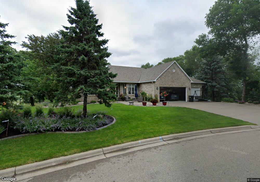
853 Amble Rd Saint Paul, MN 55126
Estimated Value: $652,000 - $914,411
4
Beds
3
Baths
2,324
Sq Ft
$358/Sq Ft
Est. Value
About This Home
This home is located at 853 Amble Rd, Saint Paul, MN 55126 and is currently estimated at $833,103, approximately $358 per square foot. 853 Amble Rd is a home located in Ramsey County with nearby schools including Island Lake Elementary School, Chippewa Middle School, and Mounds View Senior High School.
Ownership History
Date
Name
Owned For
Owner Type
Purchase Details
Closed on
Jan 6, 2023
Sold by
Fereshteh Rahimzadeh Revocable Trust
Bought by
Rahimzadeh-Kulle Revocable Trust
Current Estimated Value
Purchase Details
Closed on
Aug 20, 2020
Sold by
Mock Gary J and Mock Tracy Jo
Bought by
Rahimzadeh Fereshteh and Kulle John W
Purchase Details
Closed on
Aug 23, 2010
Sold by
Kopischke Jay K and Kopischke Kari B
Bought by
The Mock Family Trust
Purchase Details
Closed on
Aug 29, 2008
Sold by
Bergeland Michael H
Bought by
Kopischke Jay K and Kopischke Kari B
Purchase Details
Closed on
Feb 25, 1998
Sold by
R J Moser Builders Inc
Bought by
Bergeland Mike and Bergeland Betty
Create a Home Valuation Report for This Property
The Home Valuation Report is an in-depth analysis detailing your home's value as well as a comparison with similar homes in the area
Home Values in the Area
Average Home Value in this Area
Purchase History
| Date | Buyer | Sale Price | Title Company |
|---|---|---|---|
| Rahimzadeh-Kulle Revocable Trust | $500 | -- | |
| Rahimzadeh Fereshteh | $735,000 | None Available | |
| The Mock Family Trust | $602,500 | -- | |
| Kopischke Jay K | $650,000 | -- | |
| Bergeland Mike | $471,434 | -- | |
| R J Moser Builders Inc | $97,150 | -- |
Source: Public Records
Tax History Compared to Growth
Tax History
| Year | Tax Paid | Tax Assessment Tax Assessment Total Assessment is a certain percentage of the fair market value that is determined by local assessors to be the total taxable value of land and additions on the property. | Land | Improvement |
|---|---|---|---|---|
| 2025 | $12,168 | $848,100 | $167,700 | $680,400 |
| 2023 | $12,168 | $865,500 | $167,700 | $697,800 |
| 2022 | $10,554 | $794,800 | $167,700 | $627,100 |
| 2021 | $10,484 | $698,700 | $167,700 | $531,000 |
| 2020 | $10,400 | $707,700 | $167,700 | $540,000 |
| 2019 | $10,192 | $659,100 | $167,700 | $491,400 |
| 2018 | $9,784 | $679,000 | $203,100 | $475,900 |
| 2017 | $9,858 | $636,200 | $203,100 | $433,100 |
| 2016 | $10,328 | $0 | $0 | $0 |
| 2015 | $9,798 | $637,200 | $203,100 | $434,100 |
| 2014 | $10,028 | $0 | $0 | $0 |
Source: Public Records
Map
Nearby Homes
- 4297 Nancy Place
- 4250 Victoria St N
- 4444 Victoria St N
- 4454 Victoria St N
- 4237 Sylvia Ln N
- 4217 Bristol Run
- 4268 Reiland Ln
- 4186 Oxford Ct N
- 1091 Westcliff Curve
- 640 Highway 96 W
- 4525 Churchill St
- 708 Brigadoon Cir
- 4120 Victoria St N
- 550 Harbor Ct
- 592 Harbor Ct
- 599 Harbor Ct
- 742 County Road F W Unit D
- 742 County Road F W Unit 1002
- 495 Harbor Ct
- 4706 Lorinda Dr