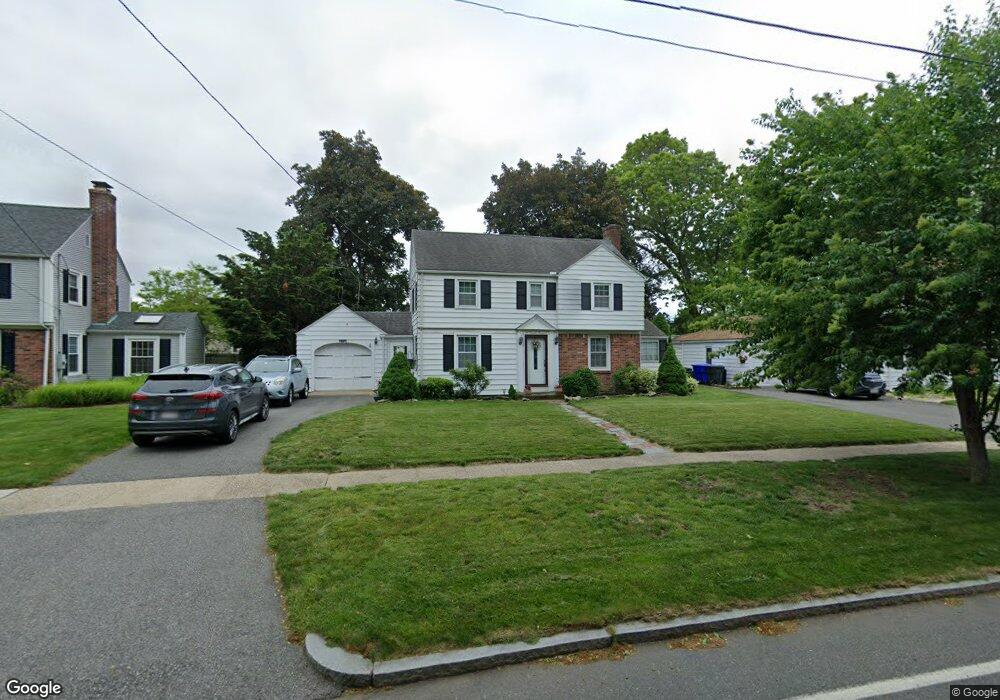
87 S Branch Pkwy Springfield, MA 01118
East Forest Park NeighborhoodEstimated Value: $345,141 - $380,000
3
Beds
2
Baths
1,441
Sq Ft
$250/Sq Ft
Est. Value
About This Home
This home is located at 87 S Branch Pkwy, Springfield, MA 01118 and is currently estimated at $360,285, approximately $250 per square foot. 87 S Branch Pkwy is a home located in Hampden County with nearby schools including Mary A. Dryden Veterans Memorial School, M Marcus Kiley Middle, and Springfield High School of Science and Technology.
Ownership History
Date
Name
Owned For
Owner Type
Purchase Details
Closed on
Oct 29, 1999
Sold by
Nadeau Ft and Dudula Mary M
Bought by
Cymer John and Cymer Barbara
Current Estimated Value
Home Financials for this Owner
Home Financials are based on the most recent Mortgage that was taken out on this home.
Original Mortgage
$102,300
Interest Rate
7.78%
Mortgage Type
Purchase Money Mortgage
Create a Home Valuation Report for This Property
The Home Valuation Report is an in-depth analysis detailing your home's value as well as a comparison with similar homes in the area
Home Values in the Area
Average Home Value in this Area
Purchase History
| Date | Buyer | Sale Price | Title Company |
|---|---|---|---|
| Cymer John | $127,900 | -- |
Source: Public Records
Mortgage History
| Date | Status | Borrower | Loan Amount |
|---|---|---|---|
| Open | Cymer John | $80,000 | |
| Closed | Cymer John | $102,300 | |
| Previous Owner | Cymer John | $58,000 |
Source: Public Records
Tax History Compared to Growth
Tax History
| Year | Tax Paid | Tax Assessment Tax Assessment Total Assessment is a certain percentage of the fair market value that is determined by local assessors to be the total taxable value of land and additions on the property. | Land | Improvement |
|---|---|---|---|---|
| 2025 | $5,174 | $330,000 | $47,300 | $282,700 |
| 2024 | $4,579 | $285,100 | $47,300 | $237,800 |
| 2023 | $4,783 | $280,500 | $45,000 | $235,500 |
| 2022 | $4,385 | $233,000 | $45,000 | $188,000 |
| 2021 | $4,201 | $222,300 | $40,900 | $181,400 |
| 2020 | $3,965 | $203,000 | $40,900 | $162,100 |
| 2019 | $3,918 | $199,100 | $40,900 | $158,200 |
| 2018 | $3,952 | $200,800 | $40,900 | $159,900 |
| 2017 | $3,639 | $185,100 | $40,900 | $144,200 |
| 2016 | $3,450 | $175,500 | $40,900 | $134,600 |
| 2015 | $3,362 | $170,900 | $40,900 | $130,000 |
Source: Public Records
Map
Nearby Homes
- 54 S Shore Dr
- 384 Abbott St
- 100 Derryfield Ave
- 74 Oregon St
- 236 Pondview Dr
- 97 Lancaster St
- 91 Lancaster St
- 7 Ashbrook St
- 283 Plumtree Rd
- 190 Whittum Ave
- 141 Hartford Terrace
- 75 Carnavon Cir
- 138 Abbott St
- 74 Leatherleaf Dr
- 74 Judith St
- 867 Roosevelt Ave
- 100 Abbott St
- 27 Regal St
- 34 Ina St
- 89 Cherokee Dr
- 81 S Branch Pkwy
- 95 S Branch Pkwy
- 32 Arvesta St
- 40 Arvesta St
- 75 S Branch Pkwy
- 24 Arvesta St
- 103 S Branch Pkwy
- 50 Arvesta St
- 100 S Branch Pkwy
- 16 Arvesta St
- 69 S Branch Pkwy
- 80 S Branch Pkwy
- 412 Gillette Ave
- 33 Arvesta St
- 63 S Branch Pkwy
- 18 S Shore Dr
- 25 Arvesta St
- 41 Arvesta St
- 465 Roosevelt Ave
- 17 Arvesta St