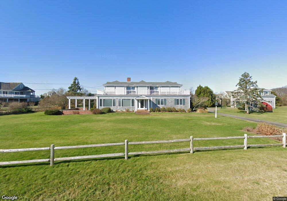
88 Edgartown Bay Rd Edgartown, MA 02539
Edgartown NeighborhoodEstimated Value: $4,664,000 - $6,309,605
4
Beds
4
Baths
3,550
Sq Ft
$1,475/Sq Ft
Est. Value
About This Home
This home is located at 88 Edgartown Bay Rd, Edgartown, MA 02539 and is currently estimated at $5,234,901, approximately $1,474 per square foot. 88 Edgartown Bay Rd is a home located in Dukes County with nearby schools including Edgartown Elementary School and Martha's Vineyard Regional High School.
Ownership History
Date
Name
Owned For
Owner Type
Purchase Details
Closed on
Apr 28, 2015
Sold by
Louis L Hoynes Jr T
Bought by
Hoynes Ft
Current Estimated Value
Purchase Details
Closed on
Aug 28, 2008
Sold by
Hoynes Louis L and Hoynes Virginia D
Bought by
Hoynes Louis L and Hoynes Louis L
Purchase Details
Closed on
Nov 3, 1997
Sold by
Brainard Tr Sally J
Bought by
Hoynes Louis and Hoynes Virginia D
Home Financials for this Owner
Home Financials are based on the most recent Mortgage that was taken out on this home.
Original Mortgage
$800,000
Interest Rate
7.31%
Mortgage Type
Purchase Money Mortgage
Create a Home Valuation Report for This Property
The Home Valuation Report is an in-depth analysis detailing your home's value as well as a comparison with similar homes in the area
Home Values in the Area
Average Home Value in this Area
Purchase History
| Date | Buyer | Sale Price | Title Company |
|---|---|---|---|
| Hoynes Ft | -- | -- | |
| Hoynes Louis L | -- | -- | |
| Hoynes Louis | $914,000 | -- |
Source: Public Records
Mortgage History
| Date | Status | Borrower | Loan Amount |
|---|---|---|---|
| Previous Owner | Hoynes Louis | $800,000 |
Source: Public Records
Tax History Compared to Growth
Tax History
| Year | Tax Paid | Tax Assessment Tax Assessment Total Assessment is a certain percentage of the fair market value that is determined by local assessors to be the total taxable value of land and additions on the property. | Land | Improvement |
|---|---|---|---|---|
| 2025 | $11,715 | $4,420,800 | $2,276,400 | $2,144,400 |
| 2024 | $10,540 | $4,133,200 | $2,276,400 | $1,856,800 |
| 2023 | $9,504 | $3,771,300 | $2,021,100 | $1,750,200 |
| 2022 | $12,318 | $4,065,276 | $2,957,676 | $1,107,600 |
| 2021 | $9,254 | $2,821,196 | $1,793,496 | $1,027,700 |
| 2020 | $9,273 | $2,767,996 | $1,793,496 | $974,500 |
| 2019 | $10,712 | $2,768,000 | $1,793,500 | $974,500 |
| 2018 | $10,066 | $2,601,000 | $1,793,500 | $807,500 |
| 2017 | $9,160 | $2,580,200 | $1,793,500 | $786,700 |
| 2016 | $8,521 | $2,354,000 | $1,650,200 | $703,800 |
| 2015 | $9,066 | $2,612,800 | $1,881,300 | $731,500 |
Source: Public Records
Map
Nearby Homes
- 24 Katama Bay View Rd
- 25 Lelands Path
- 5 Atlantic Dr Unit 5.2
- 19 Katama Dr
- 1 Field Club Dr
- 3 Somerset Ln
- 4 Somerset Ln
- 2 Farmers Rd
- 7 Martha's Way
- 23 Thaxter Ln
- 8 Old Dunhams Corner Way
- 108 Bay View
- 108 Bay View Ave
- 9 Maqua Way
- 9 Maqua Way Unit 107.13
- 16 Schoolhouse Rd
- 39 Slough Cove Rd Unit 12.2 (part of)
- 39 Slough Cove Rd
- 5 Pip'N Rd
- 5 Pipn Rd
- 19 Town Lot Cir
- 90 Edgartown Bay Rd
- 1 Town Lot Cir
- 17 Town Lot Rd
- 17 Town Lot Cir
- 22 Bay Lot Cir
- 85 Edgartown Bay Rd
- 92 Edgartown Bay Rd
- 15 Town Lot Cir
- 16 Bay Lot Cir
- 80 Edgartown Bay Rd
- 91 Edgartown Bay Rd
- 20 Bay Lot Circle Ed323 Unit 1
- 20 Bay Lot Circle Ed323
- 20 W Bay Dr
- 20 Katama Bay Rd Ed350
- 64 Edgartown Bay Rd
- 16 W Bay Dr
- 95 Edgartown Bay Rd
- 94 Edgartown Bay Rd