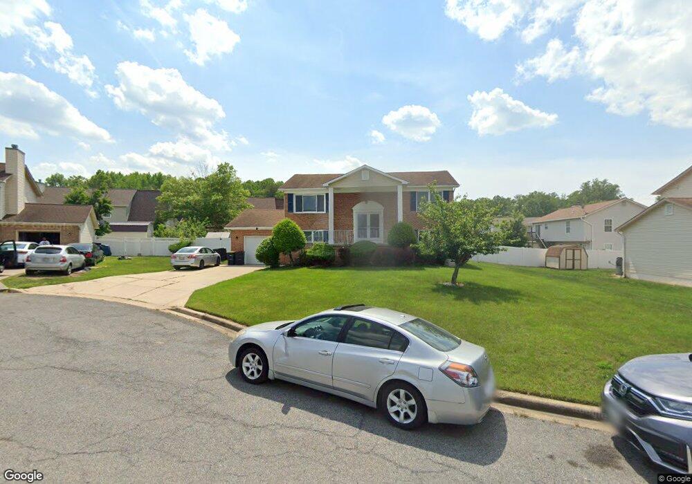
8803 Osgood Ct Clinton, MD 20735
Estimated Value: $433,000 - $510,000
Studio
3
Baths
1,120
Sq Ft
$410/Sq Ft
Est. Value
About This Home
This home is located at 8803 Osgood Ct, Clinton, MD 20735 and is currently estimated at $459,020, approximately $409 per square foot. 8803 Osgood Ct is a home located in Prince George's County with nearby schools including Clinton Grove Elementary School, Stephen Decatur Middle School, and Surrattsville High School.
Ownership History
Date
Name
Owned For
Owner Type
Purchase Details
Closed on
Sep 28, 2005
Sold by
Copes Malia and Copes Linwood Lang
Bought by
Gross James D and Gross Robin L
Current Estimated Value
Home Financials for this Owner
Home Financials are based on the most recent Mortgage that was taken out on this home.
Original Mortgage
$312,000
Outstanding Balance
$164,606
Interest Rate
5.63%
Mortgage Type
New Conventional
Estimated Equity
$294,414
Purchase Details
Closed on
Oct 15, 2002
Sold by
Lynom Mary A
Bought by
Copes Malia and Copes Linwood Langley
Purchase Details
Closed on
May 9, 1994
Sold by
Built Rite Home Dev Inc
Bought by
Lynom Mary A
Home Financials for this Owner
Home Financials are based on the most recent Mortgage that was taken out on this home.
Original Mortgage
$172,750
Interest Rate
7.7%
Create a Home Valuation Report for This Property
The Home Valuation Report is an in-depth analysis detailing your home's value as well as a comparison with similar homes in the area
Home Values in the Area
Average Home Value in this Area
Purchase History
| Date | Buyer | Sale Price | Title Company |
|---|---|---|---|
| Gross James D | $390,000 | -- | |
| Copes Malia | $230,000 | -- | |
| Lynom Mary A | $173,790 | -- |
Source: Public Records
Mortgage History
| Date | Status | Borrower | Loan Amount |
|---|---|---|---|
| Open | Lynom Mary A | $312,000 | |
| Previous Owner | Lynom Mary A | $172,750 |
Source: Public Records
Tax History
| Year | Tax Paid | Tax Assessment Tax Assessment Total Assessment is a certain percentage of the fair market value that is determined by local assessors to be the total taxable value of land and additions on the property. | Land | Improvement |
|---|---|---|---|---|
| 2025 | $5,014 | $385,800 | $101,100 | $284,700 |
| 2024 | $5,014 | $360,433 | -- | -- |
| 2023 | $4,807 | $335,067 | $0 | $0 |
| 2022 | $4,551 | $309,700 | $101,100 | $208,600 |
| 2021 | $4,367 | $297,833 | $0 | $0 |
| 2020 | $4,285 | $285,967 | $0 | $0 |
| 2019 | $4,178 | $274,100 | $100,500 | $173,600 |
| 2018 | $4,036 | $259,633 | $0 | $0 |
| 2017 | $3,919 | $245,167 | $0 | $0 |
| 2016 | -- | $230,700 | $0 | $0 |
| 2015 | $4,404 | $230,700 | $0 | $0 |
| 2014 | $4,404 | $230,700 | $0 | $0 |
Source: Public Records
Map
Nearby Homes
- 8831 Hardesty Dr
- 5801 San Juan Dr
- 5704 San Juan Dr
- 9146 Hardesty Dr
- 8801 Christina Ln
- 5715 Butterfield Dr
- 9012 Phyllis Dr
- 5210 Vienna Dr
- 6004 Butterfield Dr
- 5209 Sumter Ct
- 9505 Pryde Dr
- 8605 Sumter Ln
- 8714 Jeremy Ct
- 5904 Mardella Blvd
- 9003 Woodyard Rd
- 6003 Plata St
- 6005 Plata St
- 8805 Mimosa Ave
- 9618 Small Dr
- 4924 Plata St
Your Personal Tour Guide
Ask me questions while you tour the home.