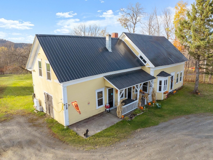
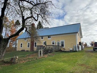
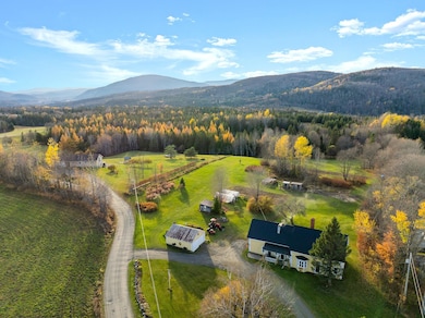
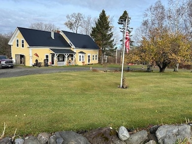
881 S Hill Rd Stewartstown, NH 03576
Estimated payment $2,736/month
Highlights
- Very Popular Property
- Colonial Architecture
- Deck
- Greenhouse
- Mountain View
- Farm
About This Home
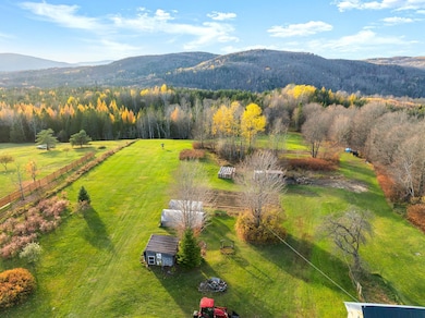
OLD CROW FARM Welcome to your private country retreat! This beautiful property offers the perfect blend of comfort, self -sufficiency and outdoor adventure The land features mature landscaping with established blueberries (39), raspberries, Concord grapes, perenial gardens and 3 large active vegetable gardens. Includes 2 greenhouses along with 2 fenced in chicken houses. Ideal for anyone who loves to grow and harvest their own food.
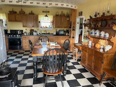
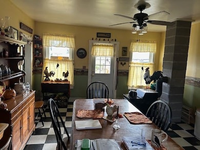
Inside, you will find a large kitchen, first floor bedroom, new full bath with walk in shower, laundry and pantry and a convenient office just off the kitchen- perfect for working from home. Hardwood floors are beautiful! A Fisher wood stove adds warmth and character to the home.
Step outside to a fenced-in dog pen, and explore your property's direct connection to the Trail 21 Snowmobile trail and Junction, with ATV access on South Hill Road. Enjoy the surrounding mountain views from your covered front porch or the large back deck.
A two car detached garage with electricity provides space for vehicles, tools and toys. This is the perfect setup for outdoor enthusiasts who want space, privacy, and adventure at their doorstep.
Whether you're looking for a peaceful homestead, a recreational getaway, or a place to live off the land, this property has it all!
Sale subject to the Sellers finding suitable housing.
Listing Agent
RE/MAX Northern Edge Realty/Colebrook License #059621 Listed on: 11/01/2025

Home Details
Home Type
- Single Family
Est. Annual Taxes
- $3,420
Year Built
- Built in 1864
Lot Details
- 5.7 Acre Lot
- Property fronts a private road
- Poultry Coop
- Corner Lot
- Garden
- Property is zoned 01-R1
Parking
- 2 Car Garage
- Gravel Driveway
Home Design
- Colonial Architecture
- Farmhouse Style Home
- Stone Foundation
- Wood Frame Construction
- Metal Roof
Interior Spaces
- Property has 1.75 Levels
- Woodwork
- Ceiling Fan
- Natural Light
- Living Room
- Den
- Wood Flooring
- Mountain Views
- Basement
- Interior Basement Entry
- Dryer
Kitchen
- Walk-In Pantry
- Freezer
Bedrooms and Bathrooms
- 3 Bedrooms
Accessible Home Design
- Accessible Full Bathroom
- Hard or Low Nap Flooring
Outdoor Features
- Deck
- Greenhouse
- Shed
- Outbuilding
Schools
- Stewartstown Community Sch Elementary School
- Choice High School
Farming
- Farm
- Agricultural
Utilities
- Spring water is a source of water for the property
- Private Water Source
- Dug Well
- Septic Tank
- Leach Field
Community Details
- Trails
Listing and Financial Details
- Tax Lot 110
- Assessor Parcel Number A4
Map
Home Values in the Area
Average Home Value in this Area
Tax History
| Year | Tax Paid | Tax Assessment Tax Assessment Total Assessment is a certain percentage of the fair market value that is determined by local assessors to be the total taxable value of land and additions on the property. | Land | Improvement |
|---|---|---|---|---|
| 2024 | $3,420 | $214,000 | $127,200 | $86,800 |
| 2023 | $3,142 | $214,000 | $127,200 | $86,800 |
| 2022 | $2,631 | $108,000 | $26,900 | $81,100 |
| 2021 | $2,662 | $111,500 | $26,900 | $84,600 |
| 2020 | $2,634 | $111,500 | $26,900 | $84,600 |
| 2019 | $2,629 | $111,500 | $26,900 | $84,600 |
| 2018 | $2,510 | $111,500 | $26,900 | $84,600 |
| 2016 | $2,214 | $92,700 | $29,600 | $63,100 |
| 2015 | $2,150 | $90,600 | $29,600 | $61,000 |
| 2014 | $2,172 | $92,900 | $29,600 | $63,300 |
| 2013 | $2,118 | $90,600 | $29,600 | $61,000 |
Property History
| Date | Event | Price | List to Sale | Price per Sq Ft |
|---|---|---|---|---|
| 11/01/2025 11/01/25 | For Sale | $465,000 | -- | $229 / Sq Ft |
Purchase History
| Date | Type | Sale Price | Title Company |
|---|---|---|---|
| Deed | $65,000 | -- | |
| Deed | $42,300 | -- |
Mortgage History
| Date | Status | Loan Amount | Loan Type |
|---|---|---|---|
| Previous Owner | $10,000 | Unknown | |
| Previous Owner | $43,644 | Purchase Money Mortgage |
Source: PrimeMLS
MLS Number: 5068177
APN: STEW-000004A-000000-000110
Disclaimer: Certain information contained herein is derived from information provided by parties other than Homes.com. All information provided is deemed reliable, but is not guaranteed to be accurate and should be independently verified.
![]() Copyright 2025 PrimeMLS, Inc. All rights reserved. This information is deemed reliable, but not guaranteed. The data relating to real estate displayed on this display comes in part from the IDX Program of PrimeMLS. The information being provided is for consumers’ personal, non-commercial use and may not be used for any purpose other than to identify prospective properties consumers may be interested in purchasing.
Copyright 2025 PrimeMLS, Inc. All rights reserved. This information is deemed reliable, but not guaranteed. The data relating to real estate displayed on this display comes in part from the IDX Program of PrimeMLS. The information being provided is for consumers’ personal, non-commercial use and may not be used for any purpose other than to identify prospective properties consumers may be interested in purchasing.
- 18 Lynch Dr
- 19 Cooke Rd
- 386 S Hill Rd
- 18 Cooke Rd
- TBD Hollow Rd
- 59 Liberty Rd
- 158 Angels Rd
- 120 Angels Rd
- 85 Angels Rd
- 621 Bishop Brook Rd
- TBD Ridge Rd
- 56 Stevens Hill Rd
- Lot 1, 2, & 3 Creampoke Rd
- 11 Downing Rd
- - Piper Hill Rd
- 869 Piper Hill Rd
- 193 Reed Rd
- 72 Heritage Rd
- 75 Heritage Rd
- - Bishop Brook Rd