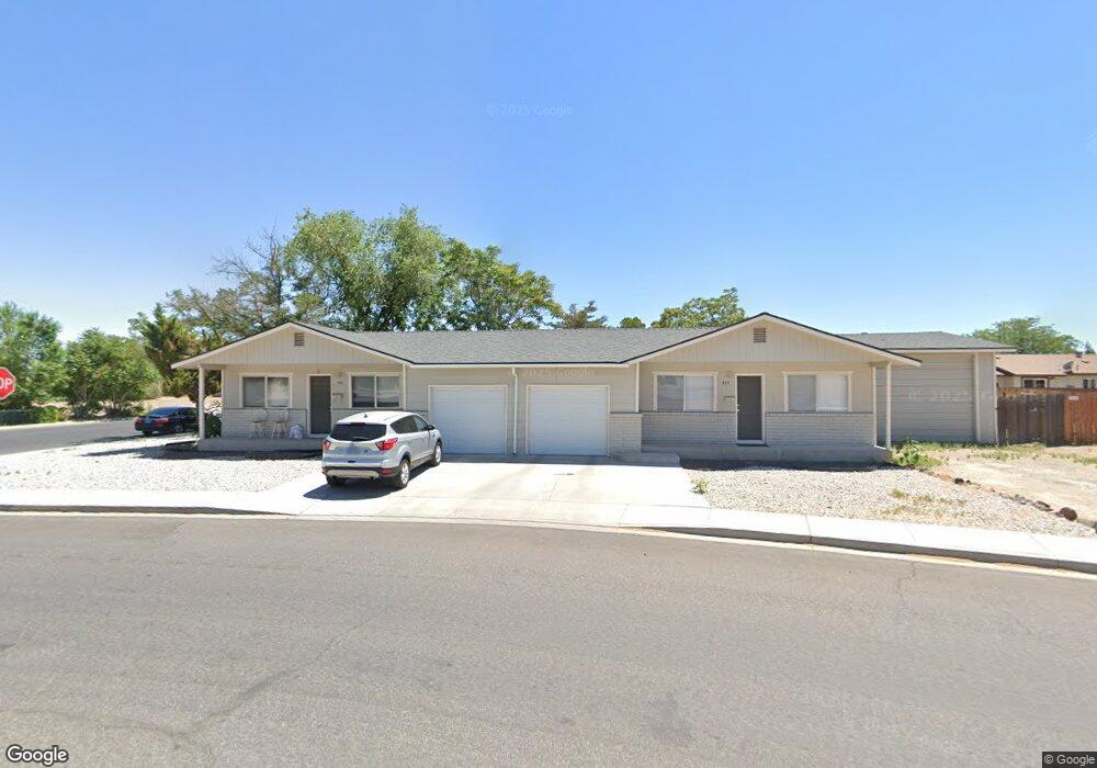
901 W Center St Fallon, NV 89406
Estimated Value: $322,000 - $440,000
4
Beds
2
Baths
1,728
Sq Ft
$215/Sq Ft
Est. Value
About This Home
This home is located at 901 W Center St, Fallon, NV 89406 and is currently estimated at $370,959, approximately $214 per square foot. 901 W Center St is a home located in Churchill County with nearby schools including Lahontan Elementary School, E.C. Best Elementary School, and Numa Elementary School.
Ownership History
Date
Name
Owned For
Owner Type
Purchase Details
Closed on
Dec 2, 2022
Sold by
Hill Family 2022 Trust
Bought by
Hill Estate Investments Llc
Current Estimated Value
Purchase Details
Closed on
Feb 12, 2020
Sold by
Pensco Trust Company Llc Custodian
Bought by
Hill Darren J and Hill Drew M
Home Financials for this Owner
Home Financials are based on the most recent Mortgage that was taken out on this home.
Original Mortgage
$187,425
Interest Rate
3.72%
Mortgage Type
New Conventional
Purchase Details
Closed on
Jul 30, 2019
Sold by
Soares Frank
Bought by
Pensco Trust Company Llc
Create a Home Valuation Report for This Property
The Home Valuation Report is an in-depth analysis detailing your home's value as well as a comparison with similar homes in the area
Home Values in the Area
Average Home Value in this Area
Purchase History
| Date | Buyer | Sale Price | Title Company |
|---|---|---|---|
| Hill Estate Investments Llc | -- | -- | |
| Hill Family 2022 Trust | -- | -- | |
| Hill Darren J | $249,900 | First Centennial Reno | |
| Pensco Trust Company Llc | $145,000 | First Centennial Reno |
Source: Public Records
Mortgage History
| Date | Status | Borrower | Loan Amount |
|---|---|---|---|
| Previous Owner | Hill Darren J | $187,425 |
Source: Public Records
Tax History
| Year | Tax Paid | Tax Assessment Tax Assessment Total Assessment is a certain percentage of the fair market value that is determined by local assessors to be the total taxable value of land and additions on the property. | Land | Improvement |
|---|---|---|---|---|
| 2025 | $1,326 | $50,199 | $19,950 | $30,249 |
| 2024 | $1,326 | $50,602 | $19,950 | $30,652 |
| 2023 | $1,326 | $46,232 | $19,950 | $26,282 |
| 2022 | $1,134 | $30,756 | $6,475 | $24,281 |
| 2021 | $963 | $26,694 | $6,475 | $20,219 |
| 2020 | $928 | $27,757 | $6,475 | $21,282 |
| 2019 | $896 | $27,961 | $6,475 | $21,486 |
| 2018 | $870 | $28,001 | $6,475 | $21,526 |
| 2017 | $845 | $28,323 | $6,475 | $21,848 |
| 2016 | $824 | $23,105 | $6,475 | $16,630 |
| 2015 | $807 | $21,253 | $6,475 | $14,778 |
| 2014 | $783 | $21,950 | $8,757 | $13,193 |
Source: Public Records
Map
Nearby Homes
- 981 Mckay Ct
- 90 S Allen St
- 475 S Bailey St
- 250 S Taylor St
- 360 & 360 1/2 W Virginia St
- 126 S Laverne St
- 1009 Deena Way
- 009-291-74 00929174
- 1044 Allen Rd
- 1.55 Acres on S Maine St
- 530 Michael Dr
- 00702160 Churchill St
- 1291 S Taylor St
- 285 Amanda Ln
- 1091 Tiffany Dr
- 687 Douglas St
- 641 Megan Way
- 1141 Alder Dr
- 290 Ferguson St
- 775 Karry Way
- 901 & 905 W Center St
- 900 Laiolo St
- 911 W Center St
- 920 Laiolo St Unit 1
- 920 Laiolo St
- 881 W Center St
- 861 W Center St
- 271 Tedford Ln
- 841 W Center St
- 940 Laiolo St Unit 1B
- 941 W Center St
- 901 Laiolo St
- 911 Laiolo St
- 12 lots Tedford Ln
- 821 W Center St
- 921 Laiolo St
- 811 W Center St Unit 1
- 811 W Center St Unit 1
- 811 W Center St
- 961 W Center St
Your Personal Tour Guide
Ask me questions while you tour the home.