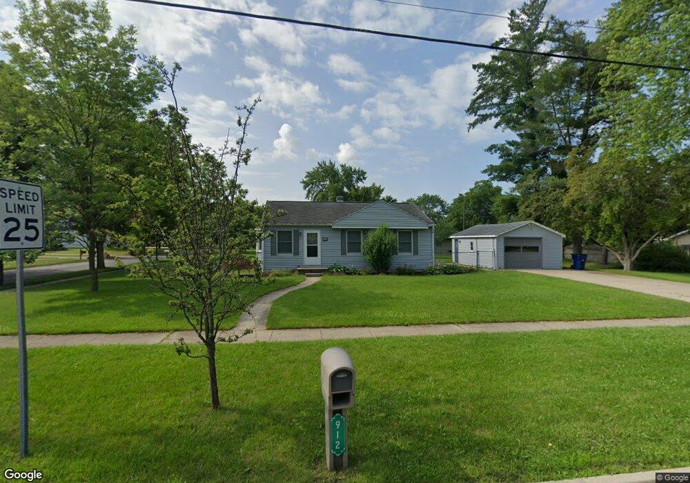
912 E Saint Andrews Rd Midland, MI 48642
Estimated Value: $159,000 - $177,131
3
Beds
1
Bath
1,029
Sq Ft
$163/Sq Ft
Est. Value
About This Home
This home is located at 912 E Saint Andrews Rd, Midland, MI 48642 and is currently estimated at $167,283, approximately $162 per square foot. 912 E Saint Andrews Rd is a home located in Midland County with nearby schools including Plymouth Elementary School, Northeast Middle School, and Midland High School.
Ownership History
Date
Name
Owned For
Owner Type
Purchase Details
Closed on
Jul 9, 2021
Sold by
Wirtz Katrin Jo and Quinlan Katrin J
Bought by
Wirtz Jason Michael and Wirtz Katrin Jo
Current Estimated Value
Purchase Details
Closed on
Mar 6, 2017
Sold by
Amy E Mynatt
Bought by
Quinlan Katrin
Home Financials for this Owner
Home Financials are based on the most recent Mortgage that was taken out on this home.
Original Mortgage
$85,424
Interest Rate
4.1%
Create a Home Valuation Report for This Property
The Home Valuation Report is an in-depth analysis detailing your home's value as well as a comparison with similar homes in the area
Home Values in the Area
Average Home Value in this Area
Purchase History
| Date | Buyer | Sale Price | Title Company |
|---|---|---|---|
| Wirtz Jason Michael | -- | None Available | |
| Wirtz Jason Michael | -- | None Listed On Document | |
| Quinlan Katrin | -- | -- |
Source: Public Records
Mortgage History
| Date | Status | Borrower | Loan Amount |
|---|---|---|---|
| Previous Owner | Quinlan Katrin | $85,424 | |
| Previous Owner | Quinlan Katrin | -- |
Source: Public Records
Tax History Compared to Growth
Tax History
| Year | Tax Paid | Tax Assessment Tax Assessment Total Assessment is a certain percentage of the fair market value that is determined by local assessors to be the total taxable value of land and additions on the property. | Land | Improvement |
|---|---|---|---|---|
| 2025 | $1,878 | $74,600 | $0 | $0 |
| 2024 | $1,460 | $64,100 | $0 | $0 |
| 2023 | $1,391 | $54,100 | $0 | $0 |
| 2022 | $1,708 | $45,600 | $0 | $0 |
| 2021 | $1,647 | $44,200 | $0 | $0 |
| 2020 | $1,664 | $42,300 | $0 | $0 |
| 2019 | $1,625 | $40,000 | $13,800 | $26,200 |
| 2018 | $1,574 | $43,100 | $13,800 | $29,300 |
| 2017 | $0 | $37,500 | $13,800 | $23,700 |
| 2016 | $1,468 | $36,100 | $13,800 | $22,300 |
| 2012 | -- | $35,800 | $13,800 | $22,000 |
Source: Public Records
Map
Nearby Homes
- 3205 Washington St
- 1120 E Sugnet Rd
- 1108 Wyllys St
- 518 E Ashman St
- 4 Hannah Ct
- 310 E Sugnet Rd
- 3710 Cambridge St
- 1708 Bauss Ct
- 3614 McKeith Rd
- 605 Chatham Dr
- 3320 Sharon Rd
- 1824 E Ashman St
- 4205 McKeith Rd
- 1914 Bauss St
- 704 E Meadowbrook Dr
- 2108 Hillgrove Pkwy
- 309 Princeton Ct
- 2108 Wyllys St
- 3702 Woodlawn St
- 218 Princeton Ct
- 912 E St Andrews
- 3409 Lancaster St
- 3405 Lancaster St
- 904 E Saint Andrews Rd
- 904 E St Andrews
- 3412 Lancaster St
- 3410 Lancaster St
- 3410 Washington St
- 3601 Lancaster St
- 3406 Lancaster St
- 3401 Lancaster St
- 3404 Washington St
- 3402 Lancaster St
- 3605 Lancaster St
- 3602 Lancaster St
- 3602 Washington St
- 3400 Washington St
- 1008 E Saint Andrews Rd
- 3606 Washington St
- 3313 Lancaster St