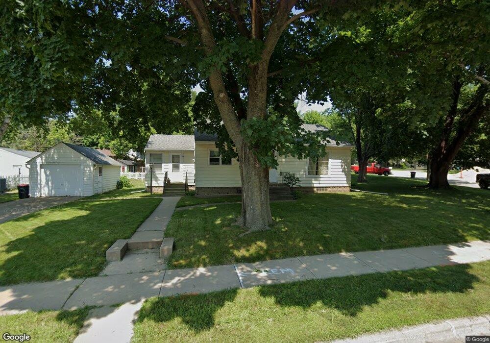
912 Maple St Red Wing, MN 55066
Estimated Value: $211,211 - $263,000
2
Beds
1
Bath
1,040
Sq Ft
$226/Sq Ft
Est. Value
About This Home
This home is located at 912 Maple St, Red Wing, MN 55066 and is currently estimated at $234,553, approximately $225 per square foot. 912 Maple St is a home located in Goodhue County with nearby schools including Sunnyside Elementary School, Burnside Elementary School, and Twin Bluff Middle School.
Ownership History
Date
Name
Owned For
Owner Type
Purchase Details
Closed on
Jun 4, 2021
Sold by
Bjorngaard Diane I
Bought by
Zolondek Matthew
Current Estimated Value
Home Financials for this Owner
Home Financials are based on the most recent Mortgage that was taken out on this home.
Original Mortgage
$184,140
Outstanding Balance
$166,716
Interest Rate
2.9%
Mortgage Type
VA
Estimated Equity
$67,837
Create a Home Valuation Report for This Property
The Home Valuation Report is an in-depth analysis detailing your home's value as well as a comparison with similar homes in the area
Home Values in the Area
Average Home Value in this Area
Purchase History
| Date | Buyer | Sale Price | Title Company |
|---|---|---|---|
| Zolondek Matthew | $180,000 | Knight Barry Ttl United Llc | |
| Zolondek Matthew Matthew | $180,000 | -- |
Source: Public Records
Mortgage History
| Date | Status | Borrower | Loan Amount |
|---|---|---|---|
| Open | Zolondek Matthew | $184,140 | |
| Closed | Zolondek Matthew Matthew | $180,000 |
Source: Public Records
Tax History
| Year | Tax Paid | Tax Assessment Tax Assessment Total Assessment is a certain percentage of the fair market value that is determined by local assessors to be the total taxable value of land and additions on the property. | Land | Improvement |
|---|---|---|---|---|
| 2025 | $2,250 | $194,300 | $60,800 | $133,500 |
| 2024 | $2,250 | $191,500 | $60,800 | $130,700 |
| 2023 | $1,147 | $181,900 | $60,700 | $121,200 |
| 2022 | $1,784 | $161,300 | $41,000 | $120,300 |
| 2021 | $1,666 | $140,100 | $41,000 | $99,100 |
| 2020 | $1,654 | $133,800 | $41,000 | $92,800 |
| 2019 | $1,654 | $125,800 | $41,000 | $84,800 |
| 2018 | $1,314 | $127,000 | $39,500 | $87,500 |
| 2017 | $1,278 | $113,100 | $39,500 | $73,600 |
| 2016 | $1,184 | $111,700 | $39,500 | $72,200 |
| 2015 | $1,134 | $109,300 | $39,500 | $69,800 |
| 2014 | -- | $105,300 | $39,500 | $65,800 |
Source: Public Records
Map
Nearby Homes
- 818 Hawthorne St
- 1020 Hawthorne St
- 1108 Hawthorne St
- 1606 Reichert Ave
- 1218 Central Ave
- 1050 Sturtevant St
- 1003 Central Ave
- 1004 College Ave
- 1315 12th St
- 814 Central Ave
- 1218 East Ave
- 1130 W 4th St
- 1227 W 4th St
- 418 8th St
- 402 W 7th St
- 1837 Bohmbach Dr
- 320 W 7th St
- 759 Plum St
- 1528 W 6th St
- 1860 Cherry St
- 1422 Roosevelt Ave
- 920 Maple St
- 1416 Roosevelt Ave
- 1415 West Ave
- 1502 Roosevelt Ave
- 1409 West Ave
- 1410 Roosevelt Ave
- 1508 Roosevelt Ave
- 826 Maple St
- 1403 West Ave
- 905 Hawthorne St
- 1417 Roosevelt Ave
- 1514 Roosevelt Ave
- 1004 Maple St
- 1005 Maple St
- 827 Hawthorne St
- 1518 Roosevelt Ave
- 820 Maple St
- 1004 Watson St
- 1012 Maple St
Your Personal Tour Guide
Ask me questions while you tour the home.