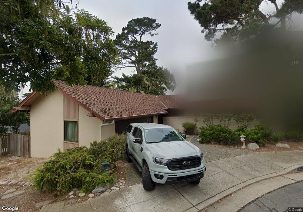
913 Laurie Cir Pacific Grove, CA 93950
Estimated Value: $1,397,000 - $1,642,000
3
Beds
2
Baths
1,516
Sq Ft
$986/Sq Ft
Est. Value
About This Home
This home is located at 913 Laurie Cir, Pacific Grove, CA 93950 and is currently estimated at $1,494,867, approximately $986 per square foot. 913 Laurie Cir is a home located in Monterey County with nearby schools including Forest Grove Elementary School, Pacific Grove Middle School, and Pacific Grove High School.
Ownership History
Date
Name
Owned For
Owner Type
Purchase Details
Closed on
Mar 20, 2002
Sold by
Fujii Gary K and Haskell Caroline T
Bought by
Fujii Gary K and Haskell Caroline T
Current Estimated Value
Create a Home Valuation Report for This Property
The Home Valuation Report is an in-depth analysis detailing your home's value as well as a comparison with similar homes in the area
Home Values in the Area
Average Home Value in this Area
Purchase History
| Date | Buyer | Sale Price | Title Company |
|---|---|---|---|
| Fujii Gary K | -- | -- |
Source: Public Records
Tax History Compared to Growth
Tax History
| Year | Tax Paid | Tax Assessment Tax Assessment Total Assessment is a certain percentage of the fair market value that is determined by local assessors to be the total taxable value of land and additions on the property. | Land | Improvement |
|---|---|---|---|---|
| 2025 | $5,282 | $509,830 | $288,905 | $220,925 |
| 2024 | $5,282 | $499,835 | $283,241 | $216,594 |
| 2023 | $5,377 | $490,036 | $277,688 | $212,348 |
| 2022 | $5,268 | $480,429 | $272,244 | $208,185 |
| 2021 | $5,239 | $471,009 | $266,906 | $204,103 |
| 2020 | $5,134 | $466,181 | $264,170 | $202,011 |
| 2019 | $4,970 | $457,041 | $258,991 | $198,050 |
| 2018 | $4,872 | $448,080 | $253,913 | $194,167 |
| 2017 | $4,791 | $439,295 | $248,935 | $190,360 |
| 2016 | $4,801 | $430,682 | $244,054 | $186,628 |
| 2015 | $4,723 | $424,214 | $240,389 | $183,825 |
| 2014 | $4,623 | $415,906 | $235,681 | $180,225 |
Source: Public Records
Map
Nearby Homes
- 765 Gibson Ave
- 700 Rosemont Ave
- 791 Spruce Ave
- 712 Sunset Dr
- 311 Walnut St
- 820 - 822 Cedar St
- 64 Spanish Bay Cir
- 52 Country Club Gate
- 311 Lobos Ave
- 304 Grove Acre Ave
- 311 Congress Ave
- 38 Country Club Gate
- 309 Congress Ave
- 222 Wood St
- 618 Forest Ave
- 302 Park St
- 616 Sage Ct
- 206 Cypress Ave Unit B
- 1007 Brentwood Ct
- 605 Acorn Ct
- 900 Weldon Grove Place
- 906 Weldon Grove Place
- 911 Laurie Cir
- 906 Laurie Cir
- 817 Workman Place
- 903 Weldon Grove Place
- 908 Laurie Cir
- 912 Weldon Grove Place
- 814 Workman Place
- 813 Workman Place
- 807 Workman Place
- 909 Weldon Grove Place
- 904 Laurie Cir
- 900 Maple St
- 894 Maple St
- 899 Sinex Ave
- 841 17 Mile Dr
- 847 17 Mile Dr
- 915 Weldon Grove Place
- 853 17 Mile Dr