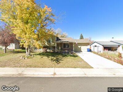
9137 W Polk Dr Littleton, CO 80123
Kipling Hills NeighborhoodEstimated Value: $526,000 - $573,000
4
Beds
5
Baths
1,036
Sq Ft
$532/Sq Ft
Est. Value
About This Home
This home is located at 9137 W Polk Dr, Littleton, CO 80123 and is currently estimated at $551,183, approximately $532 per square foot. 9137 W Polk Dr is a home located in Jefferson County with nearby schools including Powderhorn Elementary School, Summit Ridge Middle School, and Dakota Ridge Senior High School.
Ownership History
Date
Name
Owned For
Owner Type
Purchase Details
Closed on
Sep 25, 2003
Sold by
Wostrel Terry L
Bought by
Ascencio Amy L Underdown
Current Estimated Value
Home Financials for this Owner
Home Financials are based on the most recent Mortgage that was taken out on this home.
Original Mortgage
$179,100
Outstanding Balance
$89,475
Interest Rate
6.22%
Mortgage Type
Unknown
Estimated Equity
$491,652
Purchase Details
Closed on
Jun 26, 1997
Sold by
Clarence Mends and Clarence Sandra Mends
Bought by
Wostrel Terry L
Home Financials for this Owner
Home Financials are based on the most recent Mortgage that was taken out on this home.
Original Mortgage
$96,950
Interest Rate
7.93%
Create a Home Valuation Report for This Property
The Home Valuation Report is an in-depth analysis detailing your home's value as well as a comparison with similar homes in the area
Home Values in the Area
Average Home Value in this Area
Purchase History
| Date | Buyer | Sale Price | Title Company |
|---|---|---|---|
| Ascencio Amy L Underdown | $199,000 | Land Title Guarantee Company | |
| Wostrel Terry L | $138,500 | First American Heritage Titl |
Source: Public Records
Mortgage History
| Date | Status | Borrower | Loan Amount |
|---|---|---|---|
| Open | Ascencio Amy L Underdown | $179,100 | |
| Previous Owner | Wostrel Terry L | $96,950 |
Source: Public Records
Tax History Compared to Growth
Tax History
| Year | Tax Paid | Tax Assessment Tax Assessment Total Assessment is a certain percentage of the fair market value that is determined by local assessors to be the total taxable value of land and additions on the property. | Land | Improvement |
|---|---|---|---|---|
| 2024 | $3,042 | $31,063 | $10,564 | $20,499 |
| 2023 | $3,042 | $31,063 | $10,564 | $20,499 |
| 2022 | $2,790 | $27,969 | $8,651 | $19,318 |
| 2021 | $2,826 | $28,774 | $8,900 | $19,874 |
| 2020 | $2,442 | $24,923 | $6,655 | $18,268 |
| 2019 | $2,412 | $24,923 | $6,655 | $18,268 |
| 2018 | $2,272 | $22,677 | $7,152 | $15,525 |
| 2017 | $2,074 | $22,677 | $7,152 | $15,525 |
| 2016 | $1,899 | $20,039 | $5,695 | $14,344 |
| 2015 | $1,655 | $20,039 | $5,695 | $14,344 |
| 2014 | $1,655 | $16,375 | $4,594 | $11,781 |
Source: Public Records
Map
Nearby Homes
- 6523 S Field Way
- 6434 S Dudley Way
- 9565 W Coal Mine Ave Unit A
- 9693 W Euclid Dr
- 8732 W Arbor Ave
- 6705 S Field St Unit 801
- 6705 S Field St Unit 822
- 6705 S Field St Unit 803
- 9731 W Polk Dr
- 9825 W Walker Place
- 6141 S Estes St
- 6755 S Field St Unit 625
- 6722 S Independence St
- 6776 S Independence St
- 6393 S Johnson St
- 9135 W Maplewood Ave
- 8893 W Ontario Ave
- 6742 S Independence St
- 9188 W Ontario Dr
- 9562 W Capri Dr
- 9137 W Polk Dr
- 9147 W Polk Dr
- 9127 W Polk Dr
- 9180 W Weaver Dr
- 6456 S Garrison Ct
- 6446 S Garrison Ct
- 9138 W Polk Dr
- 9128 W Polk Dr
- 6460 S Garrison Ct
- 6436 S Garrison Ct
- 9157 W Polk Dr
- 9158 W Polk Dr
- 6466 S Garrison Ct
- 9140 W Weaver Dr
- 9148 W Polk Dr
- 9107 W Polk Dr
- 9209 W Weaver Dr
- 9098 W Polk Dr
- 9110 W Weaver Dr
- 9239 W Weaver Dr