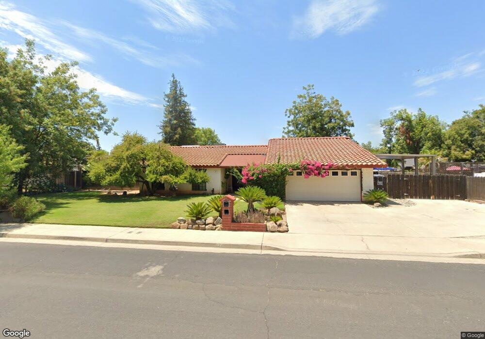
92 Lind Ave Clovis, CA 93612
Estimated Value: $437,286 - $481,000
3
Beds
2
Baths
1,776
Sq Ft
$259/Sq Ft
Est. Value
About This Home
This home is located at 92 Lind Ave, Clovis, CA 93612 and is currently estimated at $459,429, approximately $258 per square foot. 92 Lind Ave is a home located in Fresno County with nearby schools including Cole Elementary School, Alta Sierra Intermediate School, and Buchanan High School.
Ownership History
Date
Name
Owned For
Owner Type
Purchase Details
Closed on
Mar 1, 2000
Sold by
Quintero Rivas Esteranza and Irene Rivas
Bought by
Lopez Ralph
Current Estimated Value
Home Financials for this Owner
Home Financials are based on the most recent Mortgage that was taken out on this home.
Original Mortgage
$59,000
Outstanding Balance
$20,010
Interest Rate
8.3%
Estimated Equity
$439,419
Create a Home Valuation Report for This Property
The Home Valuation Report is an in-depth analysis detailing your home's value as well as a comparison with similar homes in the area
Home Values in the Area
Average Home Value in this Area
Purchase History
| Date | Buyer | Sale Price | Title Company |
|---|---|---|---|
| Lopez Ralph | $125,000 | Fidelity National Title Co |
Source: Public Records
Mortgage History
| Date | Status | Borrower | Loan Amount |
|---|---|---|---|
| Open | Lopez Ralph | $59,000 |
Source: Public Records
Tax History
| Year | Tax Paid | Tax Assessment Tax Assessment Total Assessment is a certain percentage of the fair market value that is determined by local assessors to be the total taxable value of land and additions on the property. | Land | Improvement |
|---|---|---|---|---|
| 2025 | $2,286 | $192,089 | $49,166 | $142,923 |
| 2024 | $2,242 | $188,323 | $48,202 | $140,121 |
| 2023 | $2,242 | $184,631 | $47,257 | $137,374 |
| 2022 | $2,171 | $181,012 | $46,331 | $134,681 |
| 2021 | $2,110 | $177,464 | $45,423 | $132,041 |
| 2020 | $2,102 | $175,646 | $44,958 | $130,688 |
| 2019 | $2,062 | $172,203 | $44,077 | $128,126 |
| 2018 | $2,017 | $168,827 | $43,213 | $125,614 |
| 2017 | $1,983 | $165,517 | $42,366 | $123,151 |
| 2016 | $1,917 | $162,273 | $41,536 | $120,737 |
| 2015 | $1,888 | $159,837 | $40,913 | $118,924 |
| 2014 | $1,853 | $156,707 | $40,112 | $116,595 |
Source: Public Records
Map
Nearby Homes
- 1234 No Address Available
- 288 W Magill Ave
- 127 5th St
- 474 W Windsor Ave
- 131 N Terry Ave
- 345 Sylmar Ave
- 351 N Peach Ave
- 560 W Stuart Ave
- 445 Quill Ln
- 742 W Ellery Ave
- 595 Quill Ln
- 142 9th St
- 103 Poppy Ln
- 1001 Sylmar Ave Unit 3
- 1001 Sylmar Ave Unit 131
- 1001 Sylmar Ave Unit 99
- 1001 Sylmar Ave Unit 100
- 1001 Sylmar Ave Unit 126
- 1001 Sylmar Ave Unit 155
- 1001 Sylmar Ave
- 91 Orangewood Ave
- 132 Lind Ave
- 42 Lind Ave
- 131 Orangewood Ave
- 41 Orangewood Ave
- 93 Lind Ave
- 43 Lind Ave
- 133 Lind Ave
- 182 Lind Ave
- 181 Orangewood Ave
- 90 Orangewood Ave
- 40 Orangewood Ave
- 130 Orangewood Ave
- 183 Lind Ave
- 115 W Sierra Ave
- 125 W Sierra Ave
- 180 Orangewood Ave
- 85 Villa Ave
- 105 W Sierra Ave
- 35 Villa Ave
Your Personal Tour Guide
Ask me questions while you tour the home.