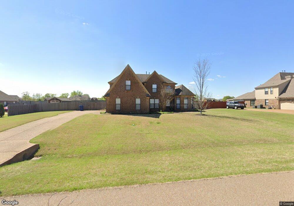
9289 Mitchell''S Corner Rd N Olive Branch, MS 38654
Lewisburg NeighborhoodEstimated Value: $375,498 - $431,000
4
Beds
3
Baths
2,649
Sq Ft
$152/Sq Ft
Est. Value
About This Home
This home is located at 9289 Mitchell''S Corner Rd N, Olive Branch, MS 38654 and is currently estimated at $401,375, approximately $151 per square foot. 9289 Mitchell''S Corner Rd N is a home located in DeSoto County with nearby schools including Lewisburg Primary School, Lewisburg Elementary School, and Lewisburg Middle School.
Ownership History
Date
Name
Owned For
Owner Type
Purchase Details
Closed on
May 25, 2017
Sold by
Ford Raymond W and Ford Ashley
Bought by
Feuer Wyatt Aaron and Feuer Maryellen Louise
Current Estimated Value
Home Financials for this Owner
Home Financials are based on the most recent Mortgage that was taken out on this home.
Original Mortgage
$149,000
Outstanding Balance
$75,672
Interest Rate
4.03%
Mortgage Type
Unknown
Estimated Equity
$325,703
Purchase Details
Closed on
Oct 29, 2010
Sold by
Keith & David Grant Homes Llc
Bought by
Ford Raymond W and Ford Ashley
Home Financials for this Owner
Home Financials are based on the most recent Mortgage that was taken out on this home.
Original Mortgage
$201,181
Interest Rate
4.2%
Mortgage Type
FHA
Create a Home Valuation Report for This Property
The Home Valuation Report is an in-depth analysis detailing your home's value as well as a comparison with similar homes in the area
Home Values in the Area
Average Home Value in this Area
Purchase History
| Date | Buyer | Sale Price | Title Company |
|---|---|---|---|
| Feuer Wyatt Aaron | -- | None Available | |
| Ford Raymond W | -- | Memphis Title Company |
Source: Public Records
Mortgage History
| Date | Status | Borrower | Loan Amount |
|---|---|---|---|
| Open | Feuer Wyatt Aaron | $149,000 | |
| Previous Owner | Ford Raymond W | $201,181 |
Source: Public Records
Tax History
| Year | Tax Paid | Tax Assessment Tax Assessment Total Assessment is a certain percentage of the fair market value that is determined by local assessors to be the total taxable value of land and additions on the property. | Land | Improvement |
|---|---|---|---|---|
| 2025 | $1,855 | $25,806 | $3,200 | $22,606 |
| 2024 | $1,599 | $18,806 | $3,200 | $15,606 |
| 2023 | $1,599 | $18,806 | $0 | $0 |
| 2022 | $1,599 | $18,806 | $3,200 | $15,606 |
| 2021 | $1,599 | $18,806 | $3,200 | $15,606 |
| 2020 | $1,471 | $17,535 | $3,200 | $14,335 |
| 2019 | $1,471 | $17,535 | $3,200 | $14,335 |
| 2017 | $1,452 | $31,254 | $17,227 | $14,027 |
| 2016 | $1,452 | $17,227 | $3,200 | $14,027 |
| 2015 | $1,752 | $31,254 | $17,227 | $14,027 |
| 2014 | $1,452 | $17,227 | $0 | $0 |
| 2013 | $1,452 | $17,227 | $0 | $0 |
Source: Public Records
Map
Nearby Homes
- 3972 Fieldstream Dr
- 9573 Park Trail Rd
- 6279 Mississippi 305
- 6606 Mississippi 305
- 3576 Holly Cove
- 9159 Mitchells Farm Cove
- 9035 Cedar Creek Dr
- 3938 McElroy Farms Dr
- 9094 Apple Orchard Cove
- 9143 Apple Orchard Cove
- 9090 Apple Orchard Cove
- 9107 Apple Orchard Cove
- 9142 Cedar Barn Cove
- 8790 Mary McCoy Dr
- 9135 Cedar Barn Cove
- 3914 Saddle Bend
- 4147 Olivia Cir W
- 4173 Olivia Cir W
- 4201 Olivia Cir W
- 4229 Olivia Cir W
- 9289 Mitchells Corner Rd N
- 9259 Mitchell''S Corner Rd N
- 9259 Mitchells Corner Rd N
- 9303 Mitchell''S Corner Rd N
- 9292 Mitchell''S Corner Rd N
- 9264 Mitchell''S Corner Rd N
- 9239 Mitchell''S Corner Rd N
- 9239 Mitchell's Corner Rd N
- 9292 Mitchells Corner Rd N
- 9239 Mitchells Corner Rd N
- 9264 Mitchells Corner Rd N
- 9312 Mitchell's Corner Rd N
- 9312 Mitchell''S Corner Rd N
- 9312 Mitchell's Corner Rd
- 3841 Mitchells Corner Rd E
- 3923 Mitchells Corner Rd E
- 9242 Mitchells Corner Rd N
- 3829 Mitchells Corner Rd E
- 3841 Mitchell's Corner Rd E
- 3901 Mitchells Corner Rd E
Your Personal Tour Guide
Ask me questions while you tour the home.