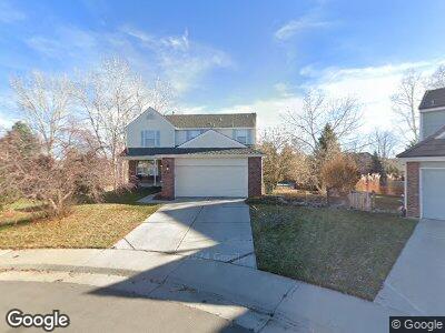
9407 W Powers Dr Littleton, CO 80123
Governor's Ranch NeighborhoodEstimated Value: $809,000 - $911,000
4
Beds
7
Baths
2,224
Sq Ft
$387/Sq Ft
Est. Value
About This Home
This home is located at 9407 W Powers Dr, Littleton, CO 80123 and is currently estimated at $859,589, approximately $386 per square foot. 9407 W Powers Dr is a home located in Jefferson County with nearby schools including Governor's Ranch Elementary School, Ken Caryl Middle School, and Columbine High School.
Create a Home Valuation Report for This Property
The Home Valuation Report is an in-depth analysis detailing your home's value as well as a comparison with similar homes in the area
Home Values in the Area
Average Home Value in this Area
Mortgage History
| Date | Status | Borrower | Loan Amount |
|---|---|---|---|
| Closed | Duncan Guy L | $30,000 | |
| Closed | Duncan Guy L | $430,400 | |
| Closed | Duncan Guy L | $419,626 | |
| Closed | Duncan Guy L | $414,529 | |
| Closed | Duncan Ouy L | $0 | |
| Closed | Duncan Guy L | $25,000 | |
| Closed | Duncan Guy L | $328,325 | |
| Closed | Duncan Guy L | $325,625 | |
| Closed | Duncan Guy L | $331,500 | |
| Closed | Duncan Guy L | $100,000 | |
| Closed | Duncan Guy L | $40,000 | |
| Closed | Duncan Guy L | $50,000 | |
| Closed | Duncan Guy L | $280,000 | |
| Closed | Duncan Guy L | $60,000 | |
| Closed | Duncan Guy L | $232,000 | |
| Closed | Duncan Guy L | $40,000 | |
| Closed | Duncan Guy L | $193,000 |
Source: Public Records
Tax History Compared to Growth
Tax History
| Year | Tax Paid | Tax Assessment Tax Assessment Total Assessment is a certain percentage of the fair market value that is determined by local assessors to be the total taxable value of land and additions on the property. | Land | Improvement |
|---|---|---|---|---|
| 2024 | $5,229 | $53,391 | $22,631 | $30,760 |
| 2023 | $5,229 | $53,391 | $22,631 | $30,760 |
| 2022 | $4,854 | $48,665 | $22,034 | $26,631 |
| 2021 | $4,917 | $50,065 | $22,668 | $27,397 |
| 2020 | $4,548 | $46,423 | $20,754 | $25,669 |
| 2019 | $4,492 | $46,423 | $20,754 | $25,669 |
| 2018 | $3,998 | $39,900 | $16,303 | $23,597 |
| 2017 | $3,649 | $39,900 | $16,303 | $23,597 |
| 2016 | $3,320 | $35,030 | $12,925 | $22,105 |
| 2015 | $3,467 | $35,030 | $12,925 | $22,105 |
| 2014 | $3,467 | $34,312 | $12,215 | $22,097 |
Source: Public Records
Map
Nearby Homes
- 5723 S Everett Way
- 5454 S Everett Ct
- 9684 W Long Dr
- 5426 S Independence St
- 5490 S Jellison St
- 9867 W Berry Dr
- 9379 W Burgundy Ave
- 9340 W Burgundy Ave
- 6010 S Garland Way
- 8705 W Berry Ave Unit 204
- 10102 W Ida Ave Unit 214
- 8615 W Berry Ave Unit 203
- 8615 W Berry Ave Unit 204
- 8775 W Berry Ave Unit 101
- 5455 S Dover St Unit 102
- 5455 S Dover St Unit 101
- 9565 W Lake Place
- 5960 S Jellison St Unit B
- 5976 S Jellison St Unit E
- 5316 S Jellison St
- 9407 W Powers Dr
- 9426 W Powers Dr
- 9427 W Powers Dr
- 9467 W Powers Dr
- 8882 W Powers Place
- 9486 W Powers Dr
- 9487 W Powers Dr
- 8881 W Powers Place
- 8923 W Cross Place
- 9545 W Powers Cir
- 8862 W Powers Place
- 9555 W Powers Cir
- 8903 W Cross Place
- 5517 S Garrison Ct
- 9524 W Powers Cir
- 5527 S Garrison Ct
- 5666 S Garland Way
- 5703 S Everett Way
- 8883 W Cross Place
- 8842 W Powers Place