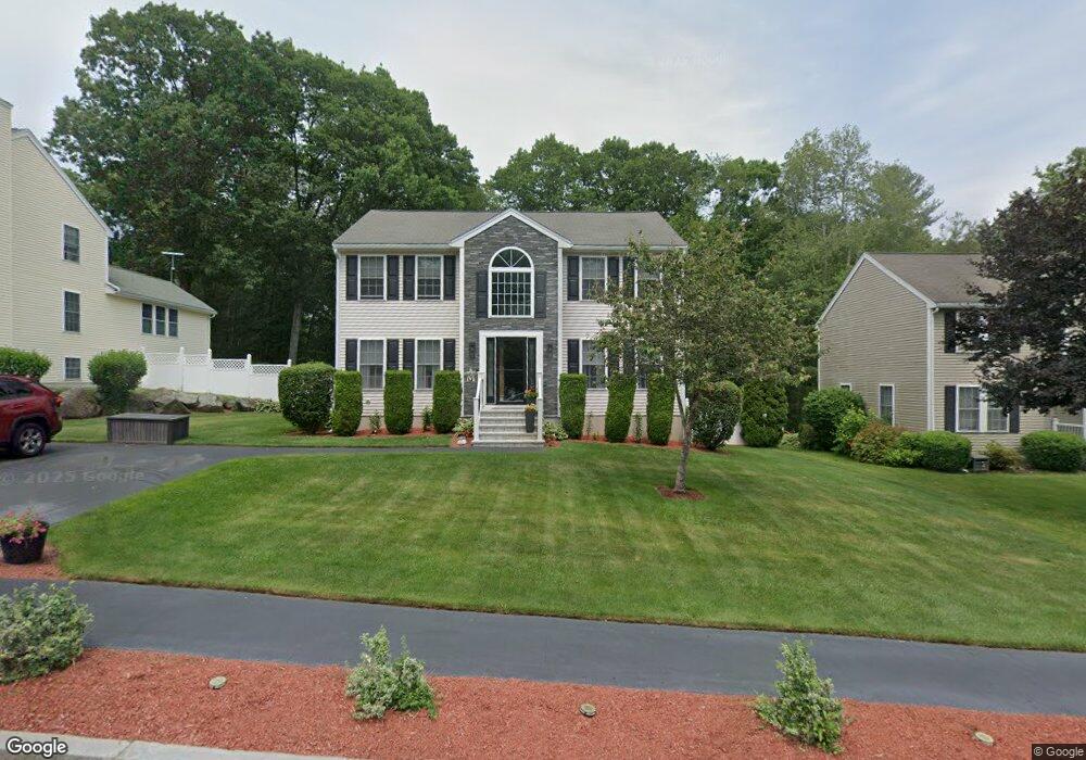
98 Photine Dr Lowell, MA 01854
Pawtucketville NeighborhoodEstimated Value: $630,000 - $659,000
3
Beds
3
Baths
2,147
Sq Ft
$303/Sq Ft
Est. Value
About This Home
This home is located at 98 Photine Dr, Lowell, MA 01854 and is currently estimated at $649,915, approximately $302 per square foot. 98 Photine Dr is a home located in Middlesex County with nearby schools including Joseph McAvinnue Elementary School, Charlotte M. Murkland Elementary School, and Dr. Gertrude Bailey Elementary School.
Ownership History
Date
Name
Owned For
Owner Type
Purchase Details
Closed on
Aug 31, 1999
Sold by
Npv Dev Llc
Bought by
Martinez Jose O and Martinez Brenda M
Current Estimated Value
Home Financials for this Owner
Home Financials are based on the most recent Mortgage that was taken out on this home.
Original Mortgage
$173,600
Interest Rate
7.53%
Mortgage Type
Purchase Money Mortgage
Create a Home Valuation Report for This Property
The Home Valuation Report is an in-depth analysis detailing your home's value as well as a comparison with similar homes in the area
Home Values in the Area
Average Home Value in this Area
Purchase History
We collect this data history from publicly available records. To have your information removed, we recommend requesting removal directly through your county’s website.
| Date | Buyer | Sale Price | Title Company |
|---|---|---|---|
| Martinez Jose O | $192,900 | -- | |
| Martinez Jose O | $192,900 | -- |
Source: Public Records
Mortgage History
We collect this data history from publicly available records. To have your information removed, we recommend requesting removal directly through your county’s website.
| Date | Status | Borrower | Loan Amount |
|---|---|---|---|
| Open | Martinez Jose O | $173,100 | |
| Closed | Martinez Jose O | $10,000 | |
| Closed | Martinez Jose O | $173,600 |
Source: Public Records
Tax History
| Year | Tax Paid | Tax Assessment Tax Assessment Total Assessment is a certain percentage of the fair market value that is determined by local assessors to be the total taxable value of land and additions on the property. | Land | Improvement |
|---|---|---|---|---|
| 2025 | $6,585 | $573,600 | $184,900 | $388,700 |
| 2024 | $6,691 | $561,800 | $172,800 | $389,000 |
| 2023 | $6,330 | $509,700 | $150,300 | $359,400 |
| 2022 | $5,774 | $455,000 | $136,600 | $318,400 |
| 2021 | $5,403 | $401,400 | $118,800 | $282,600 |
| 2020 | $5,236 | $391,900 | $121,200 | $270,700 |
| 2019 | $5,334 | $379,900 | $106,700 | $273,200 |
| 2018 | $5,301 | $368,400 | $101,700 | $266,700 |
| 2017 | $5,073 | $340,000 | $92,400 | $247,600 |
| 2016 | $5,006 | $330,200 | $86,200 | $244,000 |
| 2015 | $4,694 | $303,200 | $84,400 | $218,800 |
| 2013 | $4,515 | $300,800 | $106,000 | $194,800 |
Source: Public Records
Map
Nearby Homes
- 285 W Meadow Rd
- 15 Meadow Dr
- 104 Bedford Ave
- 1510 Skyline Dr Unit 12
- 54 Shirley Ave
- 351 Pawtucket Blvd Unit 3
- 88 Boulevard St
- 84 Fowler Rd
- 57 Magnolia St
- 187 Varnum Ave
- 1215 Pawtucket Blvd Unit 45
- 1470 Varnum Ave
- 33 Woodward Ave
- 1975 Middlesex St Unit 33
- 1975 Middlesex St Unit 2
- 81 5th Ave
- 24 Brouilette St Unit A
- 4 Tamarack St
- 2 Walter G Wiede St Unit 1
- 103 Wightman St
Your Personal Tour Guide
Ask me questions while you tour the home.