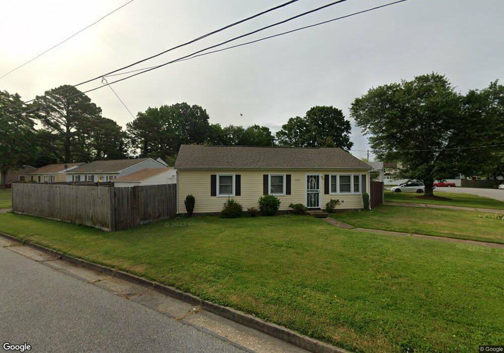
1006 Rollins Cir Hampton, VA 23663
Buckroe Beach NeighborhoodEstimated Value: $201,000 - $219,000
2
Beds
1
Bath
912
Sq Ft
$234/Sq Ft
Est. Value
About This Home
This home is located at 1006 Rollins Cir, Hampton, VA 23663 and is currently estimated at $213,356, approximately $233 per square foot. 1006 Rollins Cir is a home located in Hampton City with nearby schools including Capt. John Smith Elementary School, Benjamin Syms Middle School, and Phoebus High School.
Ownership History
Date
Name
Owned For
Owner Type
Purchase Details
Closed on
Sep 20, 2022
Sold by
Wiggins Tanika
Bought by
Ortiz Antonio
Current Estimated Value
Home Financials for this Owner
Home Financials are based on the most recent Mortgage that was taken out on this home.
Original Mortgage
$135,920
Outstanding Balance
$129,824
Interest Rate
5.22%
Mortgage Type
New Conventional
Estimated Equity
$83,532
Purchase Details
Closed on
Jul 25, 2019
Sold by
Fortune Joel R
Bought by
Wiggins Tanika
Home Financials for this Owner
Home Financials are based on the most recent Mortgage that was taken out on this home.
Original Mortgage
$134,911
Interest Rate
4.25%
Mortgage Type
FHA
Create a Home Valuation Report for This Property
The Home Valuation Report is an in-depth analysis detailing your home's value as well as a comparison with similar homes in the area
Home Values in the Area
Average Home Value in this Area
Purchase History
| Date | Buyer | Sale Price | Title Company |
|---|---|---|---|
| Ortiz Antonio | $169,900 | -- | |
| Wiggins Tanika | $137,400 | Gem Title Llc |
Source: Public Records
Mortgage History
| Date | Status | Borrower | Loan Amount |
|---|---|---|---|
| Open | Ortiz Antonio | $135,920 | |
| Previous Owner | Wiggins Tanika | $134,911 |
Source: Public Records
Tax History
| Year | Tax Paid | Tax Assessment Tax Assessment Total Assessment is a certain percentage of the fair market value that is determined by local assessors to be the total taxable value of land and additions on the property. | Land | Improvement |
|---|---|---|---|---|
| 2025 | $2,384 | $207,000 | $55,000 | $152,000 |
| 2024 | $2,113 | $183,700 | $55,000 | $128,700 |
| 2023 | $2,073 | $178,700 | $55,000 | $123,700 |
| 2022 | $1,962 | $166,300 | $50,000 | $116,300 |
| 2021 | $1,935 | $145,600 | $42,000 | $103,600 |
| 2020 | $1,667 | $134,400 | $38,300 | $96,100 |
| 2019 | $1,587 | $128,000 | $38,300 | $89,700 |
| 2018 | $1,359 | $110,700 | $38,300 | $72,400 |
| 2017 | $1,467 | $0 | $0 | $0 |
| 2016 | $1,323 | $99,100 | $0 | $0 |
| 2015 | $1,323 | $0 | $0 | $0 |
| 2014 | $1,406 | $99,100 | $38,300 | $60,800 |
Source: Public Records
Map
Nearby Homes
- 1814 Somerville Dr
- 1810 Beall Dr
- 54 George Ct
- 1841 Kensington Dr
- 304 Woodland Rd
- 1530 Morgan Dr
- 1445 Oakcrest Dr
- 1923 Rawood Dr
- 1908 Hurst Dr
- 1909 Long Green Ln
- 1915 Long Green Ln
- 1314 Saxton Dr
- 1504 E Pembroke Ave
- 1307 Colebrook Dr
- 417 Woodland Rd
- 2004 Winfree Rd
- 2007 Egger Cir
- 1515 Garrow Cir
- 208 Woodland Rd
- 438 Shelton Rd
- 1004 Rollins Cir
- 1802 Bancroft Dr
- 1801 Bancroft Dr
- 1804 Bancroft Dr
- 1002 Rollins Cir
- 1803 Bancroft Dr
- 1007 Rollins Cir
- 1005 Rollins Cir
- 1009 Rollins Cir
- 1014 Rollins Cir
- 1003 Rollins Cir
- 1805 Bancroft Dr
- 1806 Bancroft Dr
- 1011 Rollins Cir
- 1000 Rollins Cir
- 1001 Rollins Cir
- 1807 Bancroft Dr
- 1016 Rollins Cir
- 1013 Rollins Cir
- 1804 Andrews Blvd
Your Personal Tour Guide
Ask me questions while you tour the home.