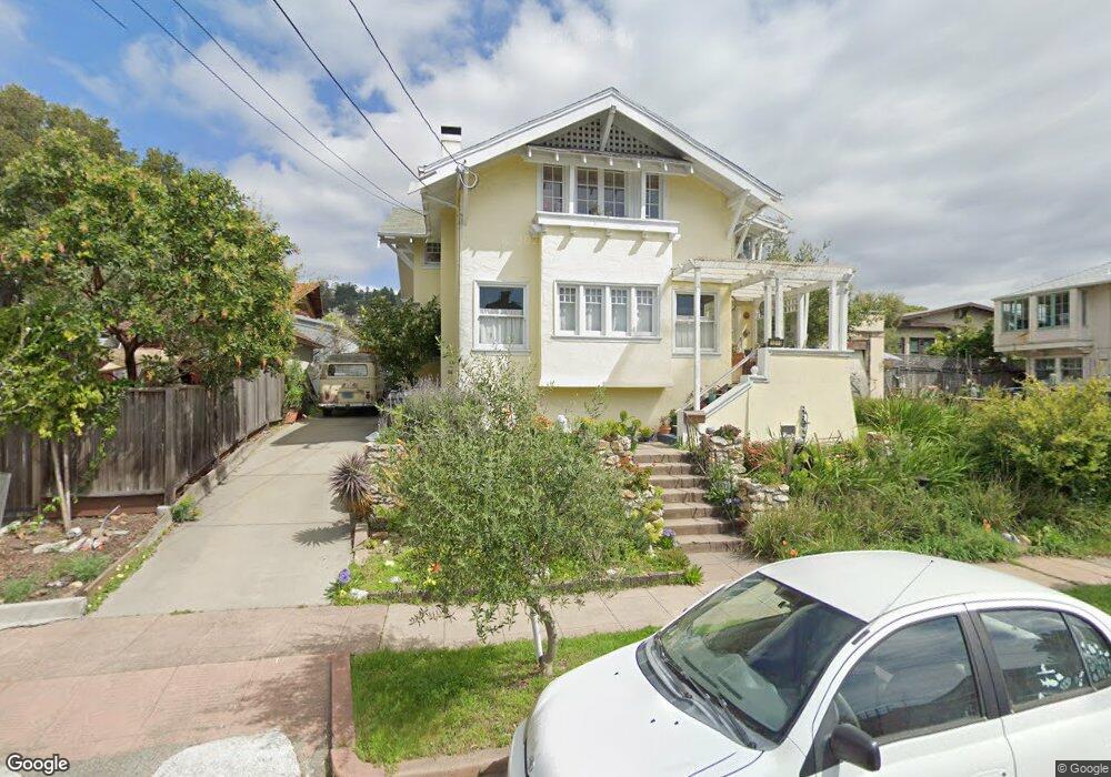
1011 Lassen St Berkeley, CA 94707
Northbrae NeighborhoodEstimated Value: $800,000 - $2,110,000
5
Beds
2
Baths
2,049
Sq Ft
$742/Sq Ft
Est. Value
About This Home
This home is located at 1011 Lassen St, Berkeley, CA 94707 and is currently estimated at $1,520,765, approximately $742 per square foot. 1011 Lassen St is a home located in Alameda County with nearby schools including Thousand Oaks Elementary School, Ruth Acty Elementary, and Berkeley Arts Magnet at Whittier School.
Ownership History
Date
Name
Owned For
Owner Type
Purchase Details
Closed on
Dec 16, 2014
Sold by
Berger Bart M and The Augustus B Berger Living T
Bought by
Berger Thomas and Calame Berger Marianne
Current Estimated Value
Home Financials for this Owner
Home Financials are based on the most recent Mortgage that was taken out on this home.
Original Mortgage
$315,000
Outstanding Balance
$241,998
Interest Rate
4%
Mortgage Type
Seller Take Back
Estimated Equity
$1,278,767
Create a Home Valuation Report for This Property
The Home Valuation Report is an in-depth analysis detailing your home's value as well as a comparison with similar homes in the area
Home Values in the Area
Average Home Value in this Area
Purchase History
| Date | Buyer | Sale Price | Title Company |
|---|---|---|---|
| Berger Thomas | $420,000 | Chicago Title Company |
Source: Public Records
Mortgage History
| Date | Status | Borrower | Loan Amount |
|---|---|---|---|
| Open | Berger Thomas | $315,000 |
Source: Public Records
Tax History
| Year | Tax Paid | Tax Assessment Tax Assessment Total Assessment is a certain percentage of the fair market value that is determined by local assessors to be the total taxable value of land and additions on the property. | Land | Improvement |
|---|---|---|---|---|
| 2025 | $8,110 | $244,177 | $112,787 | $131,390 |
| 2024 | $8,110 | $239,391 | $110,576 | $128,815 |
| 2023 | $7,855 | $234,697 | $108,408 | $126,289 |
| 2022 | $7,790 | $230,095 | $106,282 | $123,813 |
| 2021 | $7,754 | $225,585 | $104,199 | $121,386 |
| 2020 | $7,181 | $223,273 | $103,131 | $120,142 |
| 2019 | $6,710 | $218,896 | $101,109 | $117,787 |
| 2018 | $6,527 | $214,605 | $99,127 | $115,478 |
| 2017 | $6,279 | $210,397 | $97,183 | $113,214 |
| 2016 | $9,265 | $481,125 | $164,617 | $316,508 |
| 2015 | $9,112 | $696,879 | $316,167 | $380,712 |
| 2014 | $4,188 | $85,803 | $63,402 | $22,401 |
Source: Public Records
Map
Nearby Homes
- 1950 Hopkins St
- 2121 Eunice St
- 1741 Sonoma Ave
- 938 San Benito Rd
- 813 San Diego Rd
- 1983 Yosemite Rd
- 1004 Cragmont Ave
- 765 San Diego Rd
- 1858 San Lorenzo Ave
- 2315 Eunice St
- 1626 Hopkins St
- 1408 Henry St
- 758 Spruce St
- 1425 Martin Luther King jr Way
- 777 Cragmont Ave
- 1841 Vine St
- 1444 Walnut St
- 962 Regal Rd
- 753 Peralta Ave
- 1498 Sonoma Ave
- 1946 Marin Ave
- 1955 El Dorado Ave
- 1948 Marin Ave
- 1959 El Dorado Ave
- 1963 El Dorado Ave
- 1952 Marin Ave
- 1967 El Dorado Ave
- 1958 Marin Ave
- 1938 Marin Ave
- 1020 Lassen St
- 1012 Lassen St
- 1971 El Dorado Ave
- 1964 Marin Ave
- 1934 Marin Ave
- 1945 El Dorado Ave
- 1932 Marin Ave
- 1975 El Dorado Ave
- 1966 Marin Ave
- 1941 El Dorado Ave
- 1956 El Dorado Ave
Your Personal Tour Guide
Ask me questions while you tour the home.